- News
- City News
- bhubaneswar News
- Rain likely in 27 dists during weekend
Trending
Rain likely in 27 dists during weekend


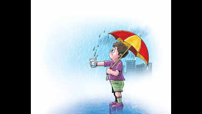
This is expected though Monday's low pressure area formed over Bay of Bengal is likely to become weak by Thursday with no significant rainfall chances, the IMD forecast said.
The system turned well-marked would maintain its intensity over west-central Bay of Bengal and likely to move northwards in the next 12 hours. Thereafter, it is likely to recurve north-northeastwards and weaken gradually over central Bay of Bengal during subsequent 24 hours, the forecast said.
Besides, there would be no large change in prevailing day temperature trend in the state for next three to four days period. Some districts recorded rain or thunderstorm activities in 24 hours. Bandhuagaon in Koraput district and Bissamcuttack in Rayagada district, each recorded highest 30 mm rainfall during the period, said IMD rainfall report recorded on Wednesday morning. Similarly, Puri recorded major one mm rainfall during the day, the IMD report said.
But at the same time, there has been very little relief from rising mercury, Boudh recorded day's highest of 42°C. Temperature in three more towns was also hovering at 39°C. Bhubaneswar recorded maximum of 35.1°C.
End of Article
FOLLOW US ON SOCIAL MEDIA


Photostories

Hot Picks
TOP TRENDING
Explore Every Corner
Across The Globe
IPL Live ScoreAJ Brown InstagramTravis KelceWayne GretzkyNikola JokicWayne Gretzky DaughterOlivier RiouxTrump TariffsAlex Ovechkin WifeTaylor SwiftCricket Live ScoreKhloe KardashianRafale Marine JetsIPL Match TodayPrince HarryOctavio DotelFernando Tatís JrIPL Points TableAnthony VolpeBest Strains in Schedule 1China TariffsUsha VanceBill GatesAyumu IwasaOctavio DotelIPL Live Score 2025Anthony SantanderIPL Purple CapIPL Orange CapIPL Schedule 2025
Hot on the Web
Cancer SymptomsSomy AliJaya BachchanShalini PandeyMahavir Jayanti 2025Good Bad Ugly First ReviewSambhavna SethSunny DeolApoorva MukhijaKing Cobra vs White Tailed MongooseSikandar Box Office CollectionSikandar Movie ReviewLiver Fat ReductionWilliam Shakespeare QuotesPest Controlling TipsPsychology TipsLung DetoxSanskrit AffirmationsKing Cobra VS MongooseWorld Unique BirdsSalman KhanUS Student VisaDelhi HeatwaveSaudi Arabia Visa BanSaudi ArabiaH-1B VisaKunal KamraPawan KalyanSaudi Arabia VisaChar Dham Yatra 2025
Trending Topics
Tahawwur RanaSoumya SwaminathanRafale Marine Fighter JetsUKSSSC Group C Recruitment 2025SEBA HSLC Result 2025Us Stock MarketF-1 VisaAssam SEBA HSLC 2025 ResultMallikarjun KhargeYuzvendra ChahalRicky PontingPriyansh AryaNavjot Singh SidhuMS DhoniShreyas IyerMohammad KaifVirat KohliShahrukh KhanJofra ArcherRJ MahvashNYT ConnectionsMark ZuckerbergGhibli Style ImageElon MuskYashasvi JaiswalFire Force Season 3Bank Holidays AprilPublic Holidays AprilCraftmine Update
Popular Categories
HeadlinesSports NewsBusiness NewsIndia NewsWorld NewsBollywood NewsHealth+ TipsIndian TV ShowsTechnologyTravelEtimesHealth & FitnessWWENFLICC Champions TrophyAstrologyWeather TodayIPLHow to watch IPL 2025How to watch IPL in CanadaHow to watch IPL in USAIPL TeamsStock Market HolidaysNSE HolidaysBSE HolidaysMCX HolidaysTechnology NewsInternational SportsPublic HolidaysBank Holidays
Latest News
When Salma Hayek REFUSED to go on a date with Donald Trump: 'He got my number and he would call me...'This simple stomach bug can cause stomach cancer if left untreatedRenewed interest in Chicago Blackhawks' high-stakes Ivan Demidov Bid mid-reconstruction focusMax Verstappen features on candies at girlfriend Kelly Piquet’s sunlit baby shower, showers her with loveMonte Carlo Masters: Novak Djokovic stunned by Alejandro Tabilo in second round‘Take a deep breath’: Jamie Dimon warns Trump’s tariffs could trigger US recessionRobert Pattinson in talks to join the cast of ‘Dune: Messiah’Assam HSLC 2025 results NOT releasing on April 10: CM Himanta Biswa Sarma confirms delayPawan Kalyan’s ex-wife Renu Desai says she feels like having a partner: ‘I still have trauma from my past’April 10 — China's counterstrike, Ayushman Bharat in Delhi, IPL: RCB vs DCYouTube TV app ‘disappears’ from Roku: Here’s how you can fix itUP approves 2% hike in Dearness Allowance for state government employeesEC gears up for poll season with training boost for election and media officersWhen Deepika Padukone said she will NOT invite Katrina Kaif to her wedding with Ranveer Singh; the 'Jagga Jasoos' actress REACTEDNo-look shot goes wrong! Yashasvi Jaiswal takes a blinder to dismiss Rashid Khan - WatchIndia’s GDP projected to grow at 6.7% in FY26, says ADBRapid spread of flesh-eating disease sparks concern in the U.S.USCIS to look into social media of visa applicants to check for anti-semitic activities
Copyright © 2025 Bennett, Coleman & Co. Ltd. All rights reserved. For reprint rights: Times Syndication Service