- News
- City News
- guwahati News
- NAKSHA launched in Arunachal’s Namsai under digital India initiative
Trending
NAKSHA launched in Arunachal’s Namsai under digital India initiative


NAKSHA, a one-year pilot programme, spans 26 states and 3 Union Territories and has selected 152 cities, with Namsai being the only district selected from Arunachal Pradesh.
The programme aims to create a comprehensive and accurate geospatial database for urban land records.
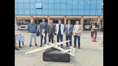
In collaboration with the Survey of India, the programme will utilise drone-based aerial surveys, field surveys, and ground truthing to map Namsai township.
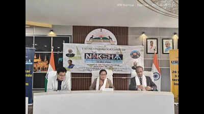
The programme was launched at the Namsai deputy commissioner's conference hall by Namsai zilla parishad chairperson Nang Urmila Mancheykhun, in the presence of director Survey of India, Shillong, RK Srivastava, Namsai deputy commissioner CR Khampa, and other senior officials.
Mancheykhun emphasised the importance of public and stakeholder cooperation for the successful implementation of NAKSHA in Namsai township.
A NAKSHA booklet, flyers, and video were released on the occasion, along with a drone demonstration by the Survey of India team.
End of Article
FOLLOW US ON SOCIAL MEDIA


Photostories

Hot Picks
TOP TRENDING
Explore Every Corner
Across The Globe
Elon MuskTaylor SwiftTriple HPakistan vs New Zealand Live StreamingGiannis AntetokounmpoNBA Buyout RumorsLebron JamesTravis KelceSteve CohenChristian GonzalezElon MuskTom BradyRanveer Allahbadia ControversyGyanesh KumarTrevor LawrenceDeshawndre WashingtonHailee SteinfeldRanveerAllahbadia CaseUPSC CSE Application DeadlineWWE Raw Results HighlightsGujarat Local Body Election ResultsManu BhakarConnor McdavidUPSC Civil Services 2025 RegistrationWorld NewsChampions Trophy Live Streaming in USAChamopions Trophy Live Streaming in CanadaICC Champions Trophy Live StreamingChampions Trophy ScheduleIPL Schedule 2025
Hot on the Web
Ranveer AllahbadiaSamay RaniaGyanesh KumarVitamin DHrithik RoshanNostradamus Predictions 2025Chhaava Movie ReviewChhaava Box Office CollectionAngelina JolieLemon Turmeric WaterOptical illusionEkta KapoorNASARani MukerjiDipika KakarCancer SymptomsLemon WaterMagnesium Deficiency SymptomsKate BeckinsaleFarah KhanMahashivratri 2025Cherry BlossomAncient AnimalsAnimal SpeciesAparajita flowersHealthy SnackingNasaSanya MalhotraUnique AnimalsWorld greatest people
Trending Topics
Gupta Power Infrastructure FraudConnor McdavidElon Musk10 Common Habits Holding YouLiam LawsoniPhone 17UP Budget SessionGBS OutbreakBook IPL 2025 Tickets OnlineRanveer AllahbadiaGrok 3 AiVladimir GuerreroChampions Trophy All Team SquadsBrain Boosting ExercisesPatrick MahomesTesla Hiring In IndiaIPL 2025 Full Match ScheduleGT IPL 2025 ScheduleMI IPL 2025 ScheduleKKR IPL 2025 ScheduleLSG IPL 2025 ScheduleCSK IPL 2025 ScheduleRCB IPL 2025 ScheduleDC IPL 2025 ScheduleSRH IPL 2025 SchedulePBKS IPL 2025 Match ScheduleRR IPL 2025 Match ScheduleChampions Trophy Live Streaming in USAChampions Trophy Live Streaming in CanadaICC Champions Trophy 2025 Live Streaming
Popular Categories
HeadlinesSports NewsBusiness NewsIndia NewsWorld NewsBollywood NewsHealth+ TipsIndian TV ShowsCelebrity PhotosTechnologyICC Champions TrophyIPLTravelEtimesHealth & FitnessHollywood NewsWeb SeriesVideosWWEUS NewsNFLBoard Exam ResultsCBSETechnology NewsInternational SportsAstrologyPublic HolidaysBank HolidaysTOISAMedithon
Latest News
Soha Ali Khan reveals how her father Mansoor Ali Khan Pataudi locked their single telephone at home: 'He would leave notes saying 'Turn off the lights'Punjab CM Bhagwant Mann hopes US Deportee flights won’t land in Amritsar againIs your partner micro-cheating on you? Here are the signs to watch out forUorfi Javed's bridal photoshoot goes viralProducer Sreenivasa Kumar responds to criticism for his remark about Telugu-speaking actresses: 'Supporting Telugu talent has always been my priority'Arijit Singh video calls his father during his Chandigarh concert; fans say 'Never ignore your parents' call' - WATCH5 Most Popular Cosmetic Sets in ValorantSGPC leadership shake-up: Dhami and Badungar resign amidst committee restructuringTook loan to send him abroad: Family of lone Himachal deporteeExclusive - Simaran Kaur on Jamai No. 1: A show that keeps you hooked with every twistJennifer Lopez devastated by Razzie Nomination amid divorce with Ben Affleck: ReportCan dementia patients live longer? Here are the simple ways towards longer life despite the diseaseIndia exported Rs 1.5 lakh crore worth of mobiles in Jan 2025: ICEACarlos Sainz net worth 2025: How much the Williams driver makes?Smoothen Chinese partnerships in electronics industry: Dixon MD2 killed as car carrying devotees from Maha Kumbh hits truck in JharkhandFood content creator Chatori Rajani's 16-year-old son dies in road accidentF1 star Ollie Bearman confesses to failing his first driving test before gearing up for full F1 season
Copyright © 2025 Bennett, Coleman & Co. Ltd. All rights reserved. For reprint rights: Times Syndication Service