- News
- City News
- ahmedabad News
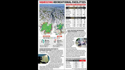
- Ahmedabad adds 3.4 sq km built-up area, Surat 3 sq km annually: Study
Trending
Ahmedabad adds 3.4 sq km built-up area, Surat 3 sq km annually: Study
Some of the key factors that influenced urban sprawl included distance to major roads, access to drainage and the slope of the land.
Titled "Predictive Modeling of Land Cover Changes in Round 1 Smart Cities of India Using Cellular Automata and GIS", the study was conducted by a collaborative team of researchers from IIT Roorkee, Purdue University (USA), and Pt Ravishankar Shukla University, Raipur.
The researchers analysed data from Landsat for the four Indian cities on parameters such as built-up area, water, forest, and open area for the years 2001, 2011 and 2021 to assess the decadal changes. They also developed a model to forecast the 2031 scenario.
In Ahmedabad, the central business district (CBD) was accessible within 9km, while major roads were within 6km. It maintained drainage systems within 800 metres and had a population density of 9,800 people per sq km.
In Surat, the CBD was accessible within 12km and major roads within 6km. The city's drainage infrastructure was available within 900 metres. It had a population density of 13,900 people sq km. Both cities exhibited relatively flat terrain, with land slopes less than 8 degrees.
The two other cities included in the study recorded diverse trends of urbanisation. While Chennai added 1.7 sq km of built-up area annually between 2001 and 2021, Jaipur added 4.4 sq km in the same period. In all the cities included in the study, a drop was seen in forest cover, open land and agricultural land to pave the way for urban development.
Ahmedabad: According to a recent study published in Springer's Discover Cities, Ahmedabad added an average of 3.4 sq km of built-up area annually between 2001 and 2021 while Surat followed closely behind, growing by 3 sq km per year during the same period. The research maps urban expansion across Ahmedabad, Surat, Chennai and Jaipur over two decades.
Some of the key factors that influenced urban sprawl included distance to major roads, access to drainage and the slope of the land.
Titled "Predictive Modeling of Land Cover Changes in Round 1 Smart Cities of India Using Cellular Automata and GIS", the study was conducted by a collaborative team of researchers from IIT Roorkee, Purdue University (USA), and Pt Ravishankar Shukla University, Raipur.
The researchers analysed data from Landsat for the four Indian cities on parameters such as built-up area, water, forest, and open area for the years 2001, 2011 and 2021 to assess the decadal changes. They also developed a model to forecast the 2031 scenario.
In Ahmedabad, the central business district (CBD) was accessible within 9km, while major roads were within 6km. It maintained drainage systems within 800 metres and had a population density of 9,800 people per sq km.
In Surat, the CBD was accessible within 12km and major roads within 6km. The city's drainage infrastructure was available within 900 metres. It had a population density of 13,900 people sq km. Both cities exhibited relatively flat terrain, with land slopes less than 8 degrees.
The two other cities included in the study recorded diverse trends of urbanisation. While Chennai added 1.7 sq km of built-up area annually between 2001 and 2021, Jaipur added 4.4 sq km in the same period. In all the cities included in the study, a drop was seen in forest cover, open land and agricultural land to pave the way for urban development.

About the Author
Parth ShastriEnd of Article
FOLLOW US ON SOCIAL MEDIA


Photostories
Hot Picks
TOP TRENDING
Explore Every Corner
Across The Globe
Popular Categories
Hot on the Web
Top Trends
Trending Topics
Emergency Box Office CollectionMonalisasSara Ali KhanBaba VangaEmergency Movie ReviewColdplaysNagarhole National ParkSaif Ali Khan InjuredMagnesium DeficiencyMemory SharpArchana Puran SinghMagnesium DeficiencyDaaku Maharaaj Box Office Collectionemergency Box Office CollectionShark Tank India 4NYT ConnectionsAmazon SaleSatya NadellaTOI News
Living and entertainment
Latest News
Easy morning routines to cut belly fatDid you know some snakes can change colours? It is the Arizona Rattlesnake“That’s not what happened” Raiders Insider squashes rumor about Ben Johnson using Tom Brady’s suffrage to land the Chicago Bears’ HC jobExclusive - Mazher Sayed on being part of Anupamaa: It’s a big leap for me, moving from a realistic show to something more beautiful and heartfeltElon Musk's mother reacts to 'Elon is a Nazi' campaign after bizarre gesture“It wasn’t just big in big games” Bill Belichick Drops Truth About Tom Brady’s Nature Amid Raiders Drama"He's pumping us up every time” The Chiefs love being around Travis Kelce, here’s whyWho is Penta El Zero Miedo? Age, Height, Networth, and the Man Behind the MaskChiefs cheerleader spills on Taylor Swift’s post-game ritual with Travis KelceAkshay Kumar recalls having fun with Salman Khan on sets of 'Mujhse Shaadi Karogi'; says THIS about doing another film with himDelaying local body polls cost Karnataka Rs 2.8k crore fundsHigh court directs Ferozepur DC to submit inquiry into ‘Jahaz ground’ within six weeksKatya Kuropas, J.J. McCarthy's fiancée, shares heartfelt message for Vikings QB on his 22nd birthday'It's hilarious': Joe Biden offers prayer before Donald Trump takes oath as President; netizens reactJind district faces rising monkey attacks; safety measures underwayHome ministry cracks down on NGOs misusing foreign contributions post FCRA expiryIndia’s LNG imports jumped 21% in 2024 as gas consumption rose 11%Paatal Lok creator Sudip Sharma indirectly criticizes Ranbir Kapoor starrer Animal: 'Glorification of violence without accountability is deeply troubling'
Copyright © 2025 Bennett, Coleman & Co. Ltd. All rights reserved. For reprint rights: Times Syndication Service