Chilly start on Monday, but back in the 70s by Tuesday
The rain is gone, but chilly weather will linger into the first half of Monday.
Lows on Monday morning fell into the low-to-mid 40s, and temperatures will still be in the 50s at lunchtime.

Make sure you put a jacket on the kids at the bus stop in the morning, as it will be around 44 degrees by 6 a.m. Highs on Monday will be in the mid 60s.
"It's not really a shorts and T-shirts weather kind of day, at least not in my book," said WRAL meteorologist Elizabeth Gardner. "Today is the coolest day we'll see all week ... with highs about 10 degrees below normal."
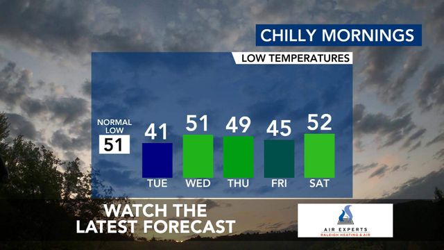
Lows will remain cool for much of the week, with the next few mornings in the 40s.
Monday night will be clear and chilly, with lows in the upper 30s to low 40s and some patchy light frost possible in some rural and low-lying areas. A frost advisory goes in effect Monday night for counties near the Virginia line.
Highs will warm into the low 70s on Tuesday and Wednesday, and the first half of the work week will stay mostly dry.

- Monday: Sunshine and clouds mixed. High of 64.
- Tuesday: Plentiful sunshine. High 73.
- Wednesday: Highs in the low 70s. We could see some sprinkles.

Sunny skies and warmth return this week
We'll have one more day in the 60s on Monday before we get a warm up. Highs should be back in the mid 70s by Wednesday.
The next chance for rain is Wednesday, but showers are not expected to be heavy or widespread. In fact, the forecast shows minimal rain chances throughout the week, offering a welcome break from the wet weather.

"Wednesday a front crosses the area," Gardner explained. "It's moisture-starved, but there could be a quick shower in the afternoon."
Humidity will be low this week as well, making it a perfect time to enjoy outdoor activities, picnics in the park, or simply soaking up the sunshine.
A warm up is in the forecast for next weekend, with highs in the upper 70s on Saturday and the low 80s on Sunday. Right now, next weekend looks dry.

It's allergy season! With all this warm weather, the flowers and trees are blooming – meaning pollen counts are high. If you're sneezing, that could be why.
7-day forecast for central NC
- Monday: Mild start to the work week. Highs in the mid 60s.
- Tuesday: It's a milder day with partly cloudy skies. High of 73.
- Wednesday: Partly cloudy and comfortable with highs in the low 70s. We could also see some sprinkles.
- Thursday: Partly cloudy skies. High of 69.
- Friday: Intervals of clouds and sunshine. High 74
- Saturday: Partly to mostly cloudy. High near 75.
- Sunday: Partly cloudy and warm with highs in the low 80s.

Prepare for a busy 2024 Atlantic hurricane season forecast
The 2024 Atlantic hurricane season will see 15 to 20 named storms in the Atlantic basin, according to researchers at North Carolina State University.
The number of named storms is significantly higher than the long-term average, and moderately higher than recent 30-year averages, according to Lian Xie, professor of marine, earth and atmospheric sciences at NC State.
In 2024, NC State researchers predict:
- 15 to named storms
- 10 to 12 may grow strong enough to become hurricanes (the historical average is six)
- Three to four becoming major hurricanes
Meanwhile, forecasters at Colorado State University are calling for 24 named storms in the 2024 Atlantic hurricane season, which runs from June 1 through Nov. 30. That is higher than the average year, when 14 storms earn a name.
CSU forecasters say 11 storms will reach hurricane strength, up from the average of seven, and five of those hurricanes could be "major," that is Category 3, 4 or 5, with winds over 111 mph.


