Better days are coming as Met Eireann forecasts warmer, drier weather for later this month
Coastal flooding in Dublin during aftermath of Storm Kathleen
Mother Nature is set to offer some relief to long-suffering farmers, gardeners and fans of the outdoors as warmer and drier conditions are forecast for the final three weeks of the month.
However, farmers desperate for an end to the cold, wet weather will have to endure another week of heavy showers before finer conditions begin to prevail.
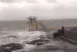
Storm Kathleen blew through Ireland over the weekend, leaving thousands without power at one point and some roads flooded.
In Belfast, the Titanic Experience was shut yesterday after its roof was damaged.
However, Met Éireann’s long-range forecast indicates a long-awaited end to the heavy rainfall from next Monday.
The following three weeks until early May will then bring finer weather conditions, with temperatures above average for the time of year and rainfall levels lower than normal.
However, farmers are worried the improvement in the weather will come too late to avert a financial crisis for producers whose animals have had to be kept indoors for weeks longer than normal because of waterlogged fields following months of heavy rainfall.
Ireland may also face a crop crisis due to late planting because of adverse weather conditions.
Farmers have been unable to get heavy machinery into fields because of the rainfall – with only a fraction of Ireland’s 21,000-acre potato crop already planted.
Producers have warned of possible retail price rises later this year due to shortages of key crops including potatoes and early cereals.
Irish Farmers Association (IFA) president Francie Gorman said farmers needed government support if they were to avoid a financial crisis, given the surge in fodder costs due to the poor weather.
Read more
Irish Creamery and Milk Suppliers’ Association (ICMSA) president Denis Drennan warned that the entire country was now under severe pressure in terms of fodder, with the south-east particularly badly hit.
Mr Drennan said some farmers had left cattle in sheds since late last September, keeping them out of waterlogged fields.
In some cases, farmers have had to borrow to pay for unexpected fodder costs.
Thousands of acres of Irish farmland is under water because of the heavy rainfall since October.
There are mounting fears that the critical first cut of silage will be badly affected by the poor weather.
IFA national potato chairperson Sean Ryan said last week that just 50 acres of Ireland’s 21,000-acre potato crop had been planted because of the bad weather.
Mr Ryan said that, unless there was a dramatic improvement in the weather and an unexpected bumper crop, there could well “be empty shelves in supermarkets (for potatoes) by the end of the year”.
Last year’s potato harvest was one of the most difficult in recent decades, with hundreds of acres not harvested because the weather was so bad. This led to an increase in potato imports.
Met Éireann has offered farmers some welcome relief, but indicated they will have to endure some further wet conditions before drier, warmer weather becomes dominant.
The forecaster indicated next week will be wet.
“Rainfall is expected to be above average overall until April 14,” a spokesperson said.
However, the weather will take a significant turn for the better from April 15.
“There is a general trend towards high pressure to become positioned to the west or south-west of Ireland, with low pressure to the east over southern Scandinavia and central Europe,” they said.
“This situation would likely produce near average or drier than normal conditions over Ireland.
“Temperatures look likely to be close to the average for mid-April.”
Weather conditions will improve even more from April 22.
“There are tentative indications that high pressure will become more of a dominant feature over Ireland through the remainder of April,” Met Éireann said.
“Under this scenario, generally settled and drier than average conditions would be favoured.
“Temperatures look likely to trend slightly above average.”
While conditions will become more unsettled from April 29, it will still be dry and warm.
“Signals are weak for this time period but they do hint at a gradual decline of high pressure, with an Atlantic regime gradually returning. Drier than normal conditions look set to persist, with slightly above average temperatures for most.”
Most homes had power restored by last night as the clean-up continued yesterday following Storm Kathleen. During the worst of the storm, on Saturday, 34,000 customers had lost power, but that number was down to several hundred last night.
The storm caused flooding across coastal areas, including in Malahide and Swords in north Co Dublin, where a number of vehicles parked overnight were partially submerged.
Meanwhile, refugee rights charity Doras criticised the Government, claiming not all homeless asylum-seekers were offered accommodation during the storm.
John Lannon, from Doras, said there had been “really poor communication” from IPAS (the International Protection Accommodation Service) “to the people trying to survive on the streets”.
He said there had been “confusion over the referral system to get an emergency bed and people being denied shelter because they weren’t on a list”.
“This is quite shocking in the weather conditions we’ve had in the last few days. It’s been left to volunteers just to keep people safe.”
The department of Integration was contacted for a comment.
Renewed weather warnings are in place for parts of the country for today.
There is a yellow warning for the south-eastern counties of Wicklow, Wexford, Waterford, Carlow and Kilkenny from midnight until midnight tomorrow.
Met Éireann said it could mean heavy rains at times, bringing possible flooding, poor visibility and difficult travelling conditions.
Join the Irish Independent WhatsApp channel
Stay up to date with all the latest news