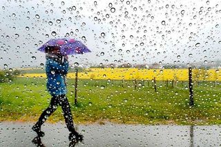
Day-long Status Orange rain warnings due for two counties, flooding expected
Ireland's 7-day weather forecast (March 11 - 17)
A Status Orange rain warning will come into effect for counties Cork and Kerry from midday, with flooding expected.
Persistent rain in the region could turn heavy at times and will be accompanied by strong winds, high tides and elevated river levels.
Cork County Council crews are on standby in several known risk locations across the county and pumping arrangements have been put in place in known problem locations for flooding.
Cork City Council is continuing to monitor the situation as between 30mm to 35mm of rainfall is expected within 24 hours.
🟠A @MetEireann Status Orange Rain warning for Cork will come into effect tomorrow Wednesday the 13th of March from 12:00 noon and will remain in effect until 12:00 noon on Thursday the 14th of March.
— Cork County Council (@Corkcoco) March 12, 2024
🟡 A Status Yellow Rain Warning is currently in place for Cork County in… pic.twitter.com/A8bSJYxIYL
A Status Yellow rain warning is currently in place for both Cork and Kerry until 12pm, with a further Status Yellow rain warning for Waterford coming into effect from 12pm.
Potential impacts include localised flooding, wave overtopping and difficult travelling conditions.
The warnings will remain in place until 12pm.
“We’re not expecting any very significant flooding across the city, we don’t expect for example the River Lee or any of its key catchments in the River Bride or the Curraheen River to burst it’s banks,” said David Joyce, the director of operations with Cork City Council.
“We’re not expecting the usual suspects. We’re not expecting the city centre to flood, which normally floods in tidal flooding conditions. We’re not expecting the west of the city to flood, which would be a normal fluvial event coming out of the River Lee.”
He told RTE’s Morning Ireland that while it is difficult to predict the locations and rates of flooding that could be seen, highly localised flooding can be expected and the drainage network should be able to handle it.
Contingency plans are in place for the city and county with crews on standby throughout today and tomorrow, he said.
“We are not expecting this to be a significant flooding event across the city for the next 24 hours. We are expecting it to be a wet, miserable, dull, rainy day today and into tonight and into tomorrow.”
Motorists, cyclists and pedestrians have been urged to drive carefully and not drive, cycle or walk through floodwaters in the event of flooding and to instead take an alternative route.
Localised flooding and difficult travel conditions are also anticipated for Kerry and Waterford.
Elsewhere, it will remain cloudy and damp across the country with outbreaks of rain and drizzle that could turn heavy at times.
There is a chance of flooding in the south and southwest of the country ahead of drier weather in the north and northwest of the country.
Highest temperatures of 8 to 12 degrees are expected.
Unusually high tides may lead to coastal wave overtopping.
Further rain is expected overnight as lowest temperatures reach between 3 to 6 degrees in north Ulster but ranging from 7 to 10 degrees elsewhere.
It will remain generally unsettled with rain and showers in the coming days, but there will be some dry and sunny weather at times.
Friday will again begin damp, though brighter weather will extend from the west throughout the morning and afternoon.
Maximum afternoon temperatures of 10 to 13 degrees in a moderate northwest breeze are expected.
Temperatures will drop on Friday night, with lowest temperatures of -1 to 3 degrees expected.
Saturday will see similar patches of rain as temperatures remain mild, with St Patrick’s Day on Sunday looking likely to clear into sunny spells and scattered showers.
However, there is the chance of a spell of persistent rain developing in the southwest later, Met Éireann forecast.
Highest temperatures of 12 to 15 degrees in a moderate southwest breeze are expected.
Join the Irish Independent WhatsApp channel
Stay up to date with all the latest news