Publications
  Partners


A heatwave in parts of the country on Tuesday will result in high temperatures, according to the South African Weather Service.
Fire danger warnings
Extremely high fire danger conditions are expected over the western and southern parts of Northern Cape, north-eastern parts of Western Cape, central and south-western parts of Free State, as well as the western parts of the Eastern Cape.
Advisories
Heatwave conditions resulting in persistently high temperatures that exceed the average maximums are expected over the central and eastern parts of Northern Cape, North West (except for the extreme north-eastern parts), Free State (except for the extreme eastern parts), as well as the interior of the Eastern Cape until Thursday - but until Wednesday in the Eastern Cape.
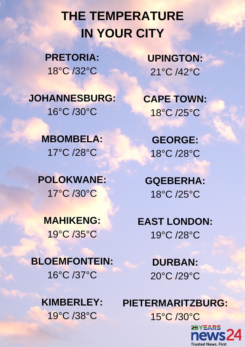
The weather in your region
Gauteng will be hot in the north, otherwise partly cloudy and warm with isolated showers and thundershowers in the afternoon.
The expected UVB sunburn index is very high.
In Mpumalanga, expect cloudy conditions with morning fog along the escarpment and southern Highveld, otherwise partly cloudy and warm with isolated showers and thundershowers, excluding the Lowveld where it will be hot.
?????Weather outlook for Tuesday, 13 February 2024.
— SA Weather Service (@SAWeatherServic) February 12, 2024
Partly cloudy and hot to warm, with isolated showers and thundershowers over the central and eastern parts. It will be very hot in places in the south-western areas. #saws #weatheroutlook #southafricanweather pic.twitter.com/nJArkafQ8G
Cloudy conditions are expected in the east of Limpopo in the morning with fog along the southern escarpment, otherwise partly cloudy and warm to hot with isolated afternoon showers and thundershowers in the south.
The North West will be partly cloudy and hot to very hot, with isolated showers and thundershowers.
It will be fine and hot to very hot in the Free State, becoming partly cloudy with isolated afternoon showers and thundershowers over the central and eastern parts.
The Northern Cape will be cloudy with fog along the coastal areas in the morning, otherwise fine and warm to hot but very hot to extremely hot in places over the central and eastern interior. It will become partly cloudy over the north-eastern parts in the afternoon.
The wind along the coast will be light to moderate southerly, becoming fresh to strong in the afternoon.
Expect fog in places over the western parts in the morning in the Western Cape, otherwise it will be cloudy to partly cloudy and cool to warm along the coastal areas, but fine and hot to very hot over the interior.
The wind along the coast will be strong westerly along the south coast at first but moderate southerly in the west and south-west, otherwise fresh south-westerly.
The expected UVB sunburn index is extreme.
The Eastern Cape will be cloudy along the coast at times, otherwise fine and hot to very hot, becoming partly cloudy in the north with isolated thunderstorms.
The wind along the coast will be moderate to fresh south-westerly.
The eastern half of the province will be partly cloudy along the coast, otherwise fine and warm to hot, becoming partly cloudy with isolated thunderstorms in the north. Fog patches are possible in the early morning south of the escarpment.
The wind along the coast will be fresh to strong north-easterly, becoming moderate to fresh south-westerly in the south by late morning.
KwaZulu-Natal will have morning fog in places over the interior, otherwise partly cloudy and warm to hot, becoming fine along the coastal areas by the afternoon.
The wind along the coast will be moderate to fresh north-easterly.
The expected UVB sunburn index is extreme.