- News
- City News
- mumbai News
- Mumbai, Thane and Palghar may see rain for 4 days from today: IMD
Trending Topics
Mumbai, Thane and Palghar may see rain for 4 days from today: IMD
You're reading

Mumbai, Thane and Palghar may see rain for 4 days from today: IMD IIMC Executive Programme in Public Policy and Management: Analysing the impact of public policy on government and corporate organisations NBFC lending grows just 2% in Q4, down from 28% last yr Bajaj MF to start ops with 3 debt plans

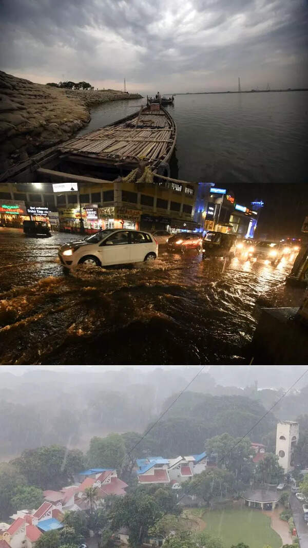
Image used for representational purpose
PUNE/MUMBAI: Biparjoy, the cyclone brewing over the Arabian Sea, is moving northnorthwestward and could drive moisture away from India and affect onset and progression of monsoon, says climate expert Roxy Mathew Koll.
Mumbai’s normal monsoon onset date is June 11. But with onset not having happened over Kerala yet, the city’s wait could get longer.
IMD, in an alert late on Tuesday evening, said, “Deep depression intensified into cyclonic storm Biparjoy over east-central Arabian Sea at 1730 hours IST. To move nearly northwards and intensify into a severe cyclonic storm during the next 24 hours. ” The Met department, in its fiveday forecast, said light to moderate rain was “very likely” from June 7-10 in parts of Mumbai, Thane and Palghar.
Koll added an exceptionally warm Arabian Sea, a weak monsoon onset and favourable Madden Julian Oscillation conditions were favouring the cyclone. The Madden-Julian Oscillation is the major fluctuation in tropical weather on weekly to monthly timescales.
“The sea surface temperatures are hovering between 31° and 32°C, 2-4°C above climatological average. This warming trend in the Arabian Sea is a consequence of climate change, and it is intensifying cyclones. In the Arabian Sea, the vertical wind shear is currently weaker than usual, resulting in subdued monsoon onset. This weakened monso- on scenario aids vertical development of cyclones,” he said.
The increase in cyclone activity in the Arabian Sea, he said, could be directly attributed to rising ocean temperatures and enhanced availability of moisture caused by global warming. Vineet Kumar Singh, researcher from Typhoon Research Centre, Jeju National University, South Korea, told TOI, “There is no cyclone threat for any coast of India, including Maharashtra. The cyclone will have no impact on the west coast. ”
Start a Conversation
FOLLOW US ON SOCIAL MEDIA
FacebookTwitterInstagramKOO APPYOUTUBE


Elections
TOP TRENDS
Popular Categories
Hot on the Web
Top Trends
Odisha train accidentJAC 9th Result 2023IND vs AUS Live ScoreTrain Accident in OdishaOdisha Train Accident ReasonCyclone BiparjoyCoromandel express accidentRohit SharmaManipur ViolenceCyclone in Arabian SeaVirat Kohli RecordsWrestlers Protest NewsIndian Navy TorpedoSL vs AFG Live ScoreMaharashtra Cabinet ExpansionNIRF Ranking 2023Manipur Internet BanWorld Test Championship Final
Trending Topics
Divya AgarwalKeerthy SureshKriti SanonViral NewsSwara Bhasker Pregnancy NewsRelationships TipsBreakfast BowlsAdipurushParenting TipsAshneer GroverRakshita ReddyZara Hatke Zara BachkeSoy Cutlets RecipesTamannaah BhatiaEsha GuptaDharsha GuptaVivo Y55sLaptops under 30000WiFi RoutersTablets under 15000
Living and entertainment
Copyright © 2023 Bennett, Coleman & Co. Ltd. All rights reserved. For reprint rights: Times Syndication Service