- News
- City News
- coimbatore News
- AAI plans colour-coded zoning map for building plan approvals
Trending Topics
AAI plans colour-coded zoning map for building plan approvals

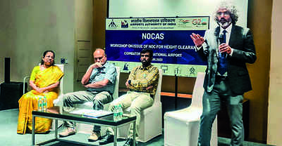
Coimbatore: The Airports Authority of India (AAI) is working on integrating a colour-coded zoning map with the revenue department’s land survey map to ease the procedure of granting approvals for building construction within 20km radius of the city airport.
Unveiling the plan, Coimbatore airport director S Senthil Valavan said the non-objection certificate (NOC) for the same was presently issued by the AAI after assessing whether the construction would affect the aircraft operations at the airport.
The AAI would check if the building height breaches the permissible top elevation level before issuing the NOC, said an official source.
The airport authorities organized a workshop on Tuesday to sensitize the officials of local bodies, electricity, BSNL and mobile tower installation agencies on the colour-coded zoning map.
Once the maps are integrated, the source said, local body officials could grant building approvals after checking the permissible top elevation level with the help of the map. “The map will show the permissible height for every survey number in the locality. The AAI will scrutinize only those applications that breach the permissible height.”
According to the director, the map would indicate the permissible elevation in the areas around the airport through different colour-coded grids. “Local body officials can verify the status of the building site with the help of the colour-coded zoning map and issue building approvals.”
Jabira M Yaseen, joint general manager, air traffic management, AAI, southern region, explained the participants about the colour-coded zoning map and the rules and regulations governing the building height around the civil aerodrome.
She said even electricity poles, trees and chimneys should be erected as per the height restrictions for each area on the map. “The AAI has the power to demolish buildings or structures violating the height rules. The height restriction is enforced to ensure the safety of aircraft and passengers travelling on them.”
Yaseen said the state authorities could not grant approvals to the sites in the approach, take-off and transitional areas of an airport or any other areas marked on the colour-coded zoning map. “Such areas will be marked in red.”
Town planning officials with the city corporation, east zone assistant commissioner Senthil Kumaran and deputy commissioner of police (south range) K Shanmugam attended the event that was held at a private hotel in the city.
Start a Conversation
FOLLOW US ON SOCIAL MEDIA
FacebookTwitterInstagramKOO APPYOUTUBE
Visual Stories


Elections
TOP TRENDS
Popular Categories
Hot on the Web
Top Trends
CSK vs GTJAC 10th Board Result 2023G20 Meeting LiveLSG vs MI EliminatorUPSC Final Result 2022PM Modi in SydneyGyanvapi Mosque CaseRs 2000 NoteIPL 2023 QualifierManipur ViolenceKarnataka SpeakerModi in AustraliaG20 Tourism MeetingWB Madhyamik ResultWBBME Result 2023Bangalore RainsIPL Schedule 2023World Test Championship Final
Trending Topics
Indian FoodVaibhavi Upadhyay Death NewsAishwarya RaiKavya GowdaMegha ShettyMarathi ActressesRelationships TipsTollywood ActressesParenting TipsAishwarya RaiCannes Red CarpetRashmika MandannaAryan KhanJanhvi KapoorPriyanka ChopraSarath Babu Death NewsVivo Y55sLaptops under 30000WiFi RoutersTablets under 15000
Living and entertainment
Copyright © 2023 Bennett, Coleman & Co. Ltd. All rights reserved. For reprint rights: Times Syndication Service