- News
- City News
- delhi News
- Delhi witnesses wettest day of 2023 on Wednesday, May's rain share crossed in 3 days
Trending Topics
Delhi witnesses wettest day of 2023 on Wednesday, May's rain share crossed in 3 days
You're reading

Delhi witnesses wettest day of 2023 on Wednesday, May's rain share crossed in 3 days Delhi HC directs authorities to act against fitting of crash guards on vehicles Fear lurks in packs: Attacks by dogs have residents worried in southwest Delhi 2 arrested for assaulting minor in Delhi airport's Terminal-1 metro station loo

Met officials said the wet spell was caused by a strong western disturbance and cyclonic circulation
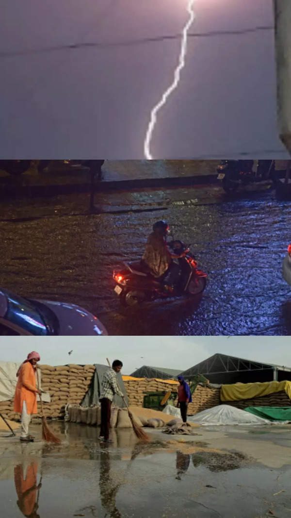
NEW DELHI: Delhi and NCR continued to experience freakishly cool and wet conditions in the peak of summer, with intense showers on Wednesday making it the wettest day of the year so far and the rainfall in the first three days of May exceeding the normal for the entire month.
After a wet start to the week, the skies opened up again from early afternoon on Wednesday, and there was widespread rain across the region. By 5.30pm, the city's base station Safdarjung had recorded 20.9mm in nine hours, the highest single-day rainfall this year, surpassing 20.4mm reported on January 30.
Safdarjung has so far logged 36.9mm of rain in the first three days of May, exceeding the month's normal rainfall of 30.7mm.
Several other parts of the city recorded higher rain while there were reports of hail at a few spots. Pitampura in northwest Delhi logged as much as 55.5mm while Mungeshpur reported 31.5mm and Lodhi Road 24.6mm.
The extremely pleasant weather continued during what is normally peak summer in the capital. The maximum temperature was recorded at 30.6 degrees Celsius, nine notches below normal, while the minimum temperature was clocked at 20.1 degree Celsius, five below normal.
The showers, however, hit commuters as traffic snarls and waterlogging was reported in some areas of the city.
Rain activity may reduce from today, temp to rise
While wet and stormy weather on Wednesday caused a flight from Mumbai to be diverted to Ahmedabad around 2.50pm, the weather department said rain activity is likely to lessen from Thursday, and the subsequent days may see just a few drizzles or light rain.
On Wednesday, Safdarjung recorded 20.9 mm of rainfall, which is considered moderate rainfall (between 15.5mm to 64.4mm). Meanwhile, Palam recorded 11.8mm, Lodhi Road recorded 24.6mm, Ridge area 14.6mm, Ayanagar 13.8mm, Mungeshpur 31.5mm, Narela 9.5mm, Pitampura 55.5mm, and Mayur Vihar recorded 8mm rainfall.
Met officials said the wet spell was caused by a strong western disturbance and cyclonic circulation. "There is a strong western disturbance trough over the western Himalayas and an cyclonic circulation over north-east Rajasthan and adjoining southern Haryana. This weather system covers entire Delhi-NCR, so the region saw consistent rain. The activity will pacify and Thursday may see drizzle or very light rain at one or two places, though the sky will remain clear. The maximum temperature will rise," said Kuldeep Srivastava, weather scientist, IMD.
He added that the temperature will gradually rise and over the next three-four days, the maximum temperature may increase by 4-5 degrees. "However, there is another western disturbance possible around May 7, which might again bring the maximum temperature down by 1-2 degrees," said Srivastava.
Meanwhile, Palam recorded 11.8mm of rainfall till 5.30pm on Wednesday, Ridge area 14.6mm, Ayanagar 13.8mm, Narela 9.5mm and Mayur Vihar 8mm.
The maximum and minimum temperature on Thursday may hover between 17 and 32 degrees respectively. The air quality saw slight deterioration from satisfactory to moderate.
Watch Rains lash Delhi
After a wet start to the week, the skies opened up again from early afternoon on Wednesday, and there was widespread rain across the region. By 5.30pm, the city's base station Safdarjung had recorded 20.9mm in nine hours, the highest single-day rainfall this year, surpassing 20.4mm reported on January 30.
Watch: Delhi-NCR is shrouded in a dense layer of fog following a day of rainfall
Safdarjung has so far logged 36.9mm of rain in the first three days of May, exceeding the month's normal rainfall of 30.7mm.
Several other parts of the city recorded higher rain while there were reports of hail at a few spots. Pitampura in northwest Delhi logged as much as 55.5mm while Mungeshpur reported 31.5mm and Lodhi Road 24.6mm.
The extremely pleasant weather continued during what is normally peak summer in the capital. The maximum temperature was recorded at 30.6 degrees Celsius, nine notches below normal, while the minimum temperature was clocked at 20.1 degree Celsius, five below normal.
The showers, however, hit commuters as traffic snarls and waterlogging was reported in some areas of the city.
Rain activity may reduce from today, temp to rise
While wet and stormy weather on Wednesday caused a flight from Mumbai to be diverted to Ahmedabad around 2.50pm, the weather department said rain activity is likely to lessen from Thursday, and the subsequent days may see just a few drizzles or light rain.
On Wednesday, Safdarjung recorded 20.9 mm of rainfall, which is considered moderate rainfall (between 15.5mm to 64.4mm). Meanwhile, Palam recorded 11.8mm, Lodhi Road recorded 24.6mm, Ridge area 14.6mm, Ayanagar 13.8mm, Mungeshpur 31.5mm, Narela 9.5mm, Pitampura 55.5mm, and Mayur Vihar recorded 8mm rainfall.
Met officials said the wet spell was caused by a strong western disturbance and cyclonic circulation. "There is a strong western disturbance trough over the western Himalayas and an cyclonic circulation over north-east Rajasthan and adjoining southern Haryana. This weather system covers entire Delhi-NCR, so the region saw consistent rain. The activity will pacify and Thursday may see drizzle or very light rain at one or two places, though the sky will remain clear. The maximum temperature will rise," said Kuldeep Srivastava, weather scientist, IMD.
He added that the temperature will gradually rise and over the next three-four days, the maximum temperature may increase by 4-5 degrees. "However, there is another western disturbance possible around May 7, which might again bring the maximum temperature down by 1-2 degrees," said Srivastava.
Meanwhile, Palam recorded 11.8mm of rainfall till 5.30pm on Wednesday, Ridge area 14.6mm, Ayanagar 13.8mm, Narela 9.5mm and Mayur Vihar 8mm.
The maximum and minimum temperature on Thursday may hover between 17 and 32 degrees respectively. The air quality saw slight deterioration from satisfactory to moderate.
Watch Rains lash Delhi
Start a Conversation
FOLLOW US ON SOCIAL MEDIA
FacebookTwitterInstagramKOO APPYOUTUBE


Elections
TOP TRENDS
Popular Categories
Hot on the Web
Top Trends
Covid NewsSame Sex MarriageWrestlers Protest NewsKarnataka Election NewsIndia China LACKashmir terrorists killedIshan KishanNEET Admit Card 2023CBSE Result date 2023Supriya SuleKing Charles III CoronationBuddha Purnima 2023Sharad Pawar NCPUPSSSC Lekhpal Result 2023Lunar Eclipse 2023Karnataka Elections 2023IPL Schedule 2023IPL 2023 Points Table
Trending Topics
Living and entertainment
Copyright © 2023 Bennett, Coleman & Co. Ltd. All rights reserved. For reprint rights: Times Syndication Service