Tornadoes in Montebello and Carpinteria damage multiple structures, sending debris flying
On Wednesday afternoon, Micaela Vargas stood in front of her Kia Telluride, which she’d parked near her workplace in Montebello.
Unfortunately for Vargas, who lives in Whittier, it seemed unlikely that she would be able to drive the vehicle home.
On top of her car and several others was a massive, leafy section of a tree, thrown there by a tornado that touched down in the area Wednesday afternoon.

The remarkable ‘bomb cyclone’ storm is losing energy as it moves southeast, but it could still cause damage and flooding, especially in the already soaked Central Valley.
Video on social media showed a dark funnel cloud forming over the Montebello area and debris flying hundreds of feet into the air.
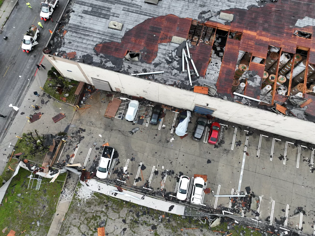
The roof was torn off a Montebello building, several others were damaged, and debris was scattered over the area.
The National Weather Service confirmed Wednesday afternoon that a tornado was responsible for the chaos and that more than 10 structures had been damaged.
The weather service sent a survey team to Montebello to examine the scene and determine whether a tornado touched down, said Kristen Stewart, a meteorologist with the National Weather Service’s Oxnard office.
One person was confirmed injured after the event. In addition, several news outlets reported that 11 buildings were red-tagged, meaning they were too dangerous to inhabit, and that an additional six buildings sustained damage due to the tornado. The National Weather Service said it was still completing its report on the damage.
The agency had already determined that a “weak” tornado touched down in Carpinteria on Tuesday. It was rated EF0 on a 0 to 5 scale and had winds of up to 75 miles per hour.
“People feel like we don’t get tornadoes in California, but we do actually get them here,” said Carol Smith, a meteorologist with the National Weather Service in Oxnard. “To get a tornado in any one spot is very rare, but to see a few of them a year is not uncommon.”
There are an average of one or two tornadoes per year in the four-county area including Los Angeles, Ventura, Santa Barbara and San Louis Obispo counties, and an average of seven to 10 per year across the state.
“It’s not like the Midwest; they are very weak, but they are tornadoes,” she said. “They do have rotation.”
The Carpinteria and Montebello tornadoes formed after recent storms pushed cold air high into the atmosphere, causing the atmosphere to destabilize. That created thunderstorm cells, which then began to rotate and ultimately become tornadoes.
Although Smith and her colleagues could see powerful thunderstorms brewing over the ocean Tuesday night, it is difficult to predict when a tornado is imminent. “You can see if there is an environment that is favorable for tornadoes to occur,” she said, “but to say, ‘Oh, there is going to be a tornado in this area,’ that’s harder.”
Smith said the Carpinteria tornado lasted two minutes. “They tend to be short-lived,” she said. They speed up, and then they die down.”
One person was injured in the incident at the Sandpiper Village mobile home park. The tornado “damaged around 25 mobile home units and there was minor tree damage to the cemetery adjacent to the mobile home park,” the weather service said.
Vargas said her experience with the Montebello tornado was frightening. She’d been looking outside to see the rain when she noticed “a little tornado started building.”
“Then all of a sudden,” she said, “it started getting so big and it started getting so gray, and you could see everything in the air.”
She saw people running to take cover in the nearby buildings.
“When it’s happening, you don’t know what to do because it’s never happened here before,” Vargas said.
The tornadoes cap a period of wild weather across California. A wet and stormy Tuesday set daily rainfall records in the area, including 1.53 inches at Long Beach Airport, which surpassed the previous record of 0.82 inches set in 1983.
Downtown Los Angeles received 1.43 inches, breaking its 130-year record of 1.34 inches, set in 1893.
The region largely fared better than the San Francisco Bay Area, where at least five people were killed, although roadway flooding, debris flows and strong winds were reported.
Flood watches were set to remain in effect through Wednesday afternoon in areas ranging from Oxnard to San Diego, including much of the L.A. Basin. Isolated showers and a brief chance of thunderstorms were expected to wane as the day went on.
High temperatures in Los Angeles were forecast to stay in the 50s — about 12 to 18 degrees below normal.
A winter storm warning was also in effect until 5 a.m. Thursday in the San Bernardino Mountains, where 60 mph wind gusts and up to 14 inches of fresh snow were possible. Blizzard conditions there earlier this month trapped scores of residents and resulted in more than a dozen deaths.
Recent snowfall totals were only a fraction of those seen during that historic event. From Tuesday to Wednesday morning, the San Bernardino County Department of Public Works recorded 10 inches of snow in Big Bear, 7 inches in Crestline, 11 inches in Lake Arrowhead, 14 inches in Running Springs and 22 inches in Green Valley Lake. Crews were planning to continue working during and after the snowfall to clear roadways, officials said.
The rest of the week should be chilly and dry in Southern California, forecasters said, but there is a chance for more rain to develop across the state as early as Monday.

California storm watch: Everything you need to know


The stories shaping California
Get up to speed with our Essential California newsletter, sent six days a week.
You may occasionally receive promotional content from the Los Angeles Times.