Top Searches
- News
- City News
- chennai News
- Oil leaked in Tamil Nadu's Nagai spreading along coast, say experts
Oil leaked in Tamil Nadu's Nagai spreading along coast, say experts

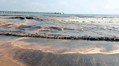
Oil spill visible on the sea shore at Pattinamchery in Nagappattinam
CHENNAI: Scientists tracking the oil spill reported off the Nagore Pattinacherry coast in Nagapattinam district last week say the floating slick could be by carried by ocean currents and wind and by March 8 extend at least 12km from the site where the leak was first reported.
An Indian National Centre for Ocean Information Services (INCOIS), Hyderabad team used computer models to generate the trajectory patterns and forecast for the spill reported on March 2.
The scientists say the spill, which reached the shore the same day and was later noticed along the coast, could spread another 2km in two days. Traces of oil may be seen along Nagapattinam beach, Keechankuppam and further south by March 8. There may also be oil particles on the sea away from the coast. As per simulations, they say, the pollutant will spread further south in the coming days due to the direction of the currents.
By March 6, it could have affected about 10.91km of the coast. Late in the even ing on March 2, crude oil leaked from the 9km long 20inch diameter pipeline from CPCL CBR Crude Storage Tanks at Nagapattinam to Karaikal Port.
Balakrishnan Nair T M, group director, ocean model, applied research and services (OMARS), INCOIS, said they generated the trajectory forecast following requests from local fishermen and NGOs.
"We do not know the actual quantity of oil spilled. But if it gets blocked by something and gets accumulated in an area, it could affect the marine ecosystem as well as tourism if oil traces are seen on beaches. Such pollutants can result in fish mortality as it could choke their gills. The spilled oil may take a month or two to settle in the sea," he said.
An INCOIS report said the spill could have affected 8.5km shoreline on March 3, 10.76km on March 4, and 10.33km on March 5. By March 7, it would have reached 11.4km and 12km by March 8.
"We are trying to get more updates like the actual quantity of oil spilled to generate forecasts for days after March 8," Balakrishnan said.
Start a Conversation
FOLLOW US ON SOCIAL MEDIA
FacebookTwitterInstagramKOO APPYOUTUBE


