Thu, Dec 22, 2022 | Updated 08.09AM IST
- City may see season’s 1st cold wave this weekend, night temp to fall below 5°C
City may see season’s 1st cold wave this weekend, night temp to fall below 5°C
ARTICLES

City may see season’s 1st cold wave this weekend, night temp to fall below 5°C These contemporary watch collections from the globally acclaimed Swiss watchmaker brand Movado are nothing short of a luxe dream Gurugram may see season's 1st cold wave this weekend, night temperature to fall below 5 degree Celsius Paradiso cave-in: Construction firm owner held by Gurugram police
Gurgaon: A cold wave may roll into the city this weekend, the first of the season, as minimum temperatures are likely to fall 1-2 degrees and hover around or below 5 degrees Celsius, the India Meteorological Department (IMD) has forecast.
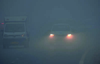
IMD on Wednesday also issued a yellow alert (to lookout for) for dense fog over the next three days. Visibility was down to 100 metres early on Wednesday morning, though it improved to 300 metres by 10am.
Residents also woke up to a minimum temperature of 7.7 degrees Celsius, a notch below the previous day. The day was chilly as fog didn’t fully lift, bringing the maximum temperature to 20.7 degrees Celsius – two degrees below normal for this time of the year.
“Due to the presence of moisture and light winds at lower tropospheric levels over the Indo-Gangetic plains, dense to very dense fog is likely over Punjab and Haryana for the next three days. Also, isolated areas of northwest India are likely to witness a cold wave on Friday and Saturday,” said Manmohan Singh, director of IMD Chandigarh.
A cold wave is declared when the minimum temperature is 10 degrees Celsius or below, and at least 4.5 notches below normal.
According to IMD, fog is considered to be ‘very dense’ when visibility is between 0 and 50 metres. That between 51 and 200 is ‘dense fog’, 201 and 500 is ‘moderate’, and 501 and 1,000 is shallow.
“There was a dense layer of fog over the entire Indo-Gangetic plains region. This could be seen clearly in satellite imagery,” Singh added.
In Haryana, the Met department has also issued an orange alert (extreme caution) for dense fog in Jhajjar, Rohtak, Sonipat, Panipat Sirsa, Fatehabad, Hisar, Jind, Bhiwani, Karnal, Kaithal, Kurukshetra and Ambala.
Meanwhile, after two days of dense to very dense fog, visibility in Delhi improved to 350 metres at Palam and Safdarjung at 5.30am, against 25 and 50 metres a day earlier.
However, there was little relief from the biting cold. The maximum temperature settled at 21.2 degrees Celsius, the lowest so far this season, against 23.2 degrees the previous day. The minimum was recorded at 7.1 degrees Celsius, a notch below normal, against 6.3 degrees a day earlier.
Very dense fog in Indo-Gangetic plains disrupted road traffic and delayed 18 trains. IGI airport officials said although operations remained normal and low visibility procedures were active between 12am and 4am, three flights had to return from Amritsar, Lucknow and Varanasi due to low visibility.
By 8.30am, the visibility improved to 500 metres. An IMD official attributed the improvement to south-westerly winds at the middle tropospheric level and a consequent increase in night temperatures in the past 24 hours. However, due to the low temperatures, high moisture and calm winds, dense to very dense fog engulfed areas in Punjab, Haryana, northwest Rajasthan, UP, Bihar and parts of Uttarakhand.
According to the weather department, fluctuation in the wind speed and temperatures will keep altering the visibility through moderate or very dense fog for the next six days. Visibility is expected to fluctuate between moderate and dense fog on December 22 and 23 and will improve from December 25 onwards, making road travel convenient around the holidays.
“There is a possibility of
improvement in visibility from December 23 onwards. However, there could be episodes of very dense or dense fog in the region for a very short duration from late night to early morning,” said RK Jenamani, senior weather scientist, IMD.
IMD has forecast dense to very dense fog in many pockets of Punjab, Haryana, Delhi and UP during night and morning hours in the next 24 hours.
FOLLOW US ON SOCIAL MEDIA
FacebookTwitterInstagramKOO APPYOUTUBE
Start a Conversation


