Top Searches
- News
- City News
- kolkata News
- Sitrang effect on Kolkata: Moderate rain, gusts at 50kmph from Monday
Sitrang effect on Kolkata: Moderate rain, gusts at 50kmph from Monday

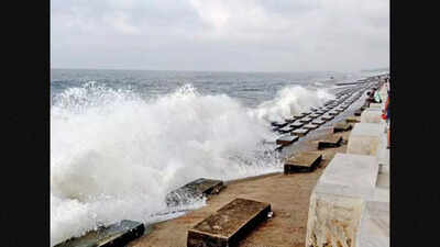
KOLKATA: Cyclone Sitrang is set to hit the Bangladesh coast between Tinkona Island and Sandweep early on Tuesday morning with a wind speed of 80-100kmph and could be preceded by heavy rain along the south Bengal coast from Monday afternoon. Kolkata and the neighbouring districts of Howrah and Hooghly could receive light to moderate showers between Monday and Tuesday afternoon.
Coastal areas of North 24 Parganas and South 24 Parganas and East Midnapore could receive moderate to heavy rain as the cyclone makes landfall and could be lashed by wind at a speed of 45-55kmph, gusting to 65kmph on Monday. Kolkata, Howrah, Hooghly and West Midnapore could receive wind at a speed of 30-40kmph, gusting to 50kmph.

On Tuesday, the wind speed could reach 80-90kmph in North 24 Parganas and South 24 Parganas, with gusts of 100kmph as the cyclone rages close to the coast and veers towards Bangladesh, passing around 180km from Kolkata. In other districts of south Bengal, the wind speed may remain 60-70kmph.
Even though the cyclonic storm will not be passing over south Bengal or Kolkata, the impact could be enough to spoil the Diwali and Kali Puja festivities that begin on the evening of October 24, said the Met office. It warned that rain will begin on Monday afternoon and may continue in the city and its neighbourhood till at least the next afternoon.
A bulletin issued by the Regional Meteorological Centre (RMC) said that the impending cyclone lay as a depression over southeast Bay of Bengal, close to west of Andaman Islands on Saturday morning.
Thursday's low-pressure area over north Andaman Sea and adjoining areas of south Andaman Sea and southeast Bay of Bengal moved west-northwestward and concentrated into a depression on Saturday morning over southeast and adjoining east-central Bay of Bengal, close to west of Andaman Islands. The system hovered about 110km north-northwest of Port Blair, 1,460km south-southeast of Sagar Island and 1,130km south-southeast of Barisal (Bangladesh).
It is likely to move northwestward and intensify further into a deep depression over east-central and adjoining southeast Bay of Bengal by Sunday morning. Subsequently, it is likely to recurve north-northeastwards, skirting the Odisha coast and intensify into a cyclonic storm over central Bay of Bengal on October 24 morning, said the RMC bulletin. Thereafter, it would continue to move north-northeastwards and cross Bangladesh coast between Tinkona Island and Sandweep on October 24.
"We expect the cyclone to make landfall between 4am and 8am on Tuesday. It could lead to heavy rain and wind along the Bengal coast but away from it, the rain could be moderate. This is due to the fact that the wind direction in Kolkata and south Bengal has now changed to northwesterly, which is dry and will not carry in clouds or rain from the cyclone. Clouds will still float in from the outer band of the cyclone, triggering moderate rain," said RMC director GK Das.
Coastal areas of North 24 Parganas and South 24 Parganas and East Midnapore could receive moderate to heavy rain as the cyclone makes landfall and could be lashed by wind at a speed of 45-55kmph, gusting to 65kmph on Monday. Kolkata, Howrah, Hooghly and West Midnapore could receive wind at a speed of 30-40kmph, gusting to 50kmph.
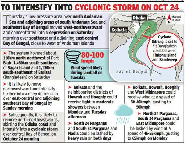
On Tuesday, the wind speed could reach 80-90kmph in North 24 Parganas and South 24 Parganas, with gusts of 100kmph as the cyclone rages close to the coast and veers towards Bangladesh, passing around 180km from Kolkata. In other districts of south Bengal, the wind speed may remain 60-70kmph.
Even though the cyclonic storm will not be passing over south Bengal or Kolkata, the impact could be enough to spoil the Diwali and Kali Puja festivities that begin on the evening of October 24, said the Met office. It warned that rain will begin on Monday afternoon and may continue in the city and its neighbourhood till at least the next afternoon.
A bulletin issued by the Regional Meteorological Centre (RMC) said that the impending cyclone lay as a depression over southeast Bay of Bengal, close to west of Andaman Islands on Saturday morning.
Thursday's low-pressure area over north Andaman Sea and adjoining areas of south Andaman Sea and southeast Bay of Bengal moved west-northwestward and concentrated into a depression on Saturday morning over southeast and adjoining east-central Bay of Bengal, close to west of Andaman Islands. The system hovered about 110km north-northwest of Port Blair, 1,460km south-southeast of Sagar Island and 1,130km south-southeast of Barisal (Bangladesh).
It is likely to move northwestward and intensify further into a deep depression over east-central and adjoining southeast Bay of Bengal by Sunday morning. Subsequently, it is likely to recurve north-northeastwards, skirting the Odisha coast and intensify into a cyclonic storm over central Bay of Bengal on October 24 morning, said the RMC bulletin. Thereafter, it would continue to move north-northeastwards and cross Bangladesh coast between Tinkona Island and Sandweep on October 24.
"We expect the cyclone to make landfall between 4am and 8am on Tuesday. It could lead to heavy rain and wind along the Bengal coast but away from it, the rain could be moderate. This is due to the fact that the wind direction in Kolkata and south Bengal has now changed to northwesterly, which is dry and will not carry in clouds or rain from the cyclone. Clouds will still float in from the outer band of the cyclone, triggering moderate rain," said RMC director GK Das.
FOLLOW US ON SOCIAL MEDIA
FacebookTwitterInstagramKOO APPYOUTUBE
Start a Conversation
end of article


FOLLOW US ON
Popular Categories
Hot on the Web
Top Trends
Russia Ukraine War LiveCoronavirus in India LiveUK PM NewsRozgar MelaRishi SunakAustralia vs New ZealandT20 World CupPM Modi LiveRangoli for DiwaliBoris JohnsonEkadashi 2022India Covid CasesIndia vs Pakistan T20 World CupDhanteras 2022UPSSSC PET Answer Key 2022Himachal Pradesh Assembly ElectionsCryptocurrency Price in IndiaHoroscope Today
Trending Topics
Diwali WishesDhanteras QuotesDhanteras WishesRashmika MandannaVaishali Takkar NewsChoti Diwali WishesDiwali Gift IdeaUrfi Javed Viral VideoSardar CollectionDiwali Rangoli DesignsSardar Movie ReviewJanhvi KapoorAkanksha DubeyShehnaaz Gill LookKapil SharmaPrince Twitter ReviewVivo Y55sLaptops under 30000WiFi RoutersTablets under 15000
Living and entertainment
Copyright © 2022 Bennett, Coleman & Co. Ltd. All rights reserved. For reprint rights: Times Syndication Service