Top Searches
- News
- City News
- kolkata News
- Cyclone Sitrang Live Updates: Cyclone Sitrang set to strike Bangladesh coast today
Cyclone Sitrang Live Updates: Cyclone Sitrang set to strike Bangladesh coast today
Cyclone Sitrang likely to gain further strength to become severe cyclonic storm, IMD said. Cyclone Sitrang is set to strike the Bangladesh coast early on Monday, even as Kolkata started getting rain late on Sunday evening with some parts of the city receiving light showers. Stay with TOI for more updates:Read Less
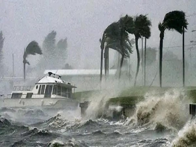
Sunderbans likely to bear brunt of cyclone Sitrang
Cyclone Sitrang is set to strike the Bangladesh coast early on Monday, although Kolkata started getting rain late on Sunday evening with some parts of the city receiving light showers. The rain is set to get heavier and continue till Tuesday afternoon, said the Met office. The cyclone is set to hit land between Tinkona Island and Sandweep in Bangladesh, close to Barishal. Fishermen have been asked to return to the shores and tourists have been asked to stay out of the sea.
Cyclonic storm Sitrang over west-central & adjoining east-central Bay of Bengal moved nearly northwards with a speed of 10 kmph and laid centered at 2030 hours IST of the 23rd October over the same region near latitude 16.60 N and longitude 88.10E, about 740 km northwest of Port Blair, 560 km south of Sagar Island and 720 km south-southwest of Barisal (Bangladesh). It is very likely to move north-northeastwards, intensify further into a severe cyclonic storm tomorrow, the 24th October. Continuing to move north-northeastwards thereafter, it is very likely to cross Bangladesh coast between Tinkona Island and Sandwip close to Barisal around 25th October early morning. Detail bulletin follows.
IMD issues advisory pertaining to suspension of offshore activities in north Bay of Bengal on October 24-25 along with issuing a warning of the possible impact of the storm in North & South 24 Parganas & East Midnapore districts of West Bengal
The cyclonic storm “SITRANG” pronounced as “Si-Trang” over westcentral & adjoining eastcentral Bay of Bengal moved nearly northwards with a speed of 10 kmph during past 06 hours and lay centered at 2030 hours IST of today, the 23rd October over the same region near latitude 16.6 0 N and longitude 88.10E, about 740 km northwest of Port Blair, 560 km south of Sagar Island and 720 km south-southwest of Barisal (Bangladesh). It is very likely to move north-northeastwards, intensify further into a severe cyclonic storm tomorrow, the 24th October. Continuing to move north-northeastwards thereafter, it is very likely to cross Bangladesh coast between Tinkona Island and Sandwip close to Barisal around 25th October early morning
Cyclone Sitrang likely to gain further strength to become severe cyclonic storm: IMD
IMD issues alert for heavy rains in several districts of Assam over next 2 days
Necessary precautions regarding the cyclone ('Sitrang') have been worked out. More impact is expected in Kolkata, so teams will be deployed in the control room & every borough office for 24 hours: Debasish Kumar, mayor-in-council, Kolkata Municipal Corporation
Cyclonic storm Sitrang to move north-northeastwards and cross Bangladesh coast between Tinkona Island and Sandwip: IMD
Preparations under way in view of cyclonic storm 'Sitrang' in South 24 Parganas; security forces deployed along river banks. (ANI)

IMD gives cyclone-alert near West Bengal coast in coming days
Deep depression intensifies into cyclone, heading towards Bangladesh
The deep depression over the Bay of Bengal intensified into a cyclonic storm on Sunday evening, and is heading towards the Bangladesh coast, the India Meteorological Department (IMD) said. Read more
Deep depression over Bay of Bengal intensifies into cyclonic storm 'Sitrang': IMD. (PTI)
The tide level is likely to be higher at Bangladesh coast, as the height of waves due to the cyclone will be around two metres, Bandopadhyay said.
The height of the waves due to the cyclone will be one metre above astronomical tide level, but since new moon is on October 25, the tide level owing to it will be five to six metres at West Bengal and Bangladesh coasts, so effective height of the tide at the time of landfall on the morning of that day will be around six metres in North and South 24 Parganas,
Deputy director general of Regional Met Centre, Sanjib Bandopadhyay
Deep depression over west-central & adjoining east-central Bay of Bengal moved northwestwards with a speed of 18 kmph during past 6 hours & is very likely to move northwestwards during next 6 hrs & intensify into a cyclonic storm over the central Bay of Bengal: IMD
Bandopadhay said the major concern is breakage of kutcha embankments, owing to storm surge accompanied with high astronomical tide on new moon, which may lead to sea water inundation of low-lying areas in these places.
The main affected area will be the Sunderbans in the coastal areas of North and South 24 Parganas districts of West Bengal and in Bangladesh.
Deputy director general of Regional Met Centre, Sanjib Bandopadhyay
The deep depression over central Bay of Bengal (BoB) is likely to intensify into a cyclonic storm by Sunday evening and after changing course in a northeastward direction from northwest, the system will reach north BoB before making landfall between Tinkona Island and Sandwip close to Bangladesh's Barisal in the early morning of Tuesday, a top official said.
Cyclone over Bay of Bengal to mainly impact Sunderbans, heavy rain forecast for Bengal
The cyclonic storm developing in the Bay of Bengal will primarily impact the Sunderbans spread over West Bengal and Bangladesh, as tidal waves are likely to reach a height of six metres owing to the twin effect of the weather system and astronomical tide, the Met Department said on Sunday.
It advised suspension of ferry services in Sunderbans and waterbound tourist activities at seaside resort towns of Digha, Mandarmoni, Shankarpur, Bakkhali and Sagar on Monday and Tuesday.