 It predicted that the water level may increase to 206.5 metres between 3 pm and 5 pm. (File)
 India Monsoon News HIghlights September 27, 2022: The southwest monsoon has further retreated from Delhi, Punjab and Chandigarh, according to India Meteorological Department (IMD) official.
It has also withdrawn partly from the areas of Jammu and Kashmir, Himachal Pradesh, western Uttar Pradesh, Haryana and Rajasthan.
The monsoon arrived in Delhi on June 30 and so far, the national capital has recorded 516.9 mm of rainfall, 19 per cent short of the normal of 639.7 mm. The monsoon withdrawal is declared when specific conditions — prevalence of dry weather for five days and reduction in moisture — are met.
Meanwhile, the IMD has predicted thunderstorms in Chattisgarh, Jharkhand and Vidarbha while Tamil Nadu and Puducherry, Coastal Andhra Pradesh and North Interior Karnataka are expected to receive heavy rains.
A ‘yellow’ warning has also been issued for several districts of Telangana with the likelihood of light to moderate rain or thunderstorms with lightning for the week ahead.

The Southwest monsoon further retreated from Delhi, Punjab and Chandigarh, the India Meteorological Department (IMD) officials said.
The monsoon also withdrew partly from the areas of Jammu and Kashmir, Himachal Pradesh, western Uttar Pradesh, Haryana and Rajasthan.
As of Thursday, the monsoon withdrawal line passed through Jammu, Una, Chandigarh, Karnal, Baghpat, Delhi, Alwar, Jodhpur and Nalia.
The monsoon arrived in Delhi on June 30 when the IMD declared its onset. Delhi has so far this season recorded 516.9 mm of rainfall, 19 per cent short of the normal of 639.7 mm. Delhi has not received rainfall from Sunday onwards after a heavy spell last week.
The southwest monsoon withdrawal has remained sluggish so far this year. It is yet to completely withdraw from the remaining regions of Rajasthan and Gujarat.
The monsoon withdrawal is declared when specific conditions — prevalence of dry weather for five days and reduction in moisture — are met.
Read more-
https://indianexpress.com/article/cities/delhi/southwest-monsoon-withdraws-from-delhi-other-northern-parts-imd-8180351/
Several areas of Tamil Nadu’s capital Chennai witnessed waterlogging Wednesday due to the long spell of rains that lashed the city.
Anna Nagar, Thiruvanmiyur, Perungudi, West Mambalam, Villivakkam, Tambaram, Nungambakkam, Ashok Nagar, Eekaatuthangal and OMR experienced waterlogging Wednesday, causing difficulties to the motorists. Read more
The water level in Yamuna in Delhi has receded slightly but it is still above the danger mark of 205.33 metres. The affected people will have to wait for a few more days before they can return to their houses in low-lying areas along the river, officials said on Thursday. It is likely to drop below the danger mark of 205.33 metres during the day.
The city administration had issued a flood alert, suspended rail traffic movement on the Old Yamuna Bridge and evacuated around 6,500 people from low-lying areas close to the Yamuna on Tuesday as the river breached the evacuation mark of 206 metres following a late spell of heavy rain in the upper catchment areas, especially Uttarakhand and Himachal Pradesh, last week. (PTI)
Mumbai weather is forecasted to stay cloud and light rain is possible today.
The southwest monsoon has started its slow withdrawal in the country. Last Tuesday, the IMD had declared the commencement of the monsoon withdrawal from southwest Rajasthan and small portions of Kutch. But some rains are likely over Kutch in the coming days, the weather models indicated.
Thunderstorm predicted in Chattisgarh, Jharkhand and Vidarbha. Tamil Nadu and Puducherr, Coastal Andhra Pradesh and North Interior Karnataka are expected to receive heavy rains.
Delhi logged a maximum temperature of 34.2 degrees Celsius, normal for this time of the year and the minimum temperature settled at 23.6 degrees Celsius.
The maximum temperature is likely to hover around 35 degrees Celsius for the next three to four days, the India Meteorological Department (IMD) said.
The capital recorded a 24-hour average air quality index of 140 (moderate category).
Mahesh Palawat, vice-president (meteorology and climate change) of Skymet Weather, said the southwest monsoon will retreat from some more parts of west Rajasthan, Punjab, Haryana, and the Saurashtra and Kutch regions of Gujarat in the next two to three days.
Subsequently, it will withdraw from Delhi-NCR by October 1-2, he said.
The IMD said the line of withdrawal of the southwest monsoon currently passes through Khajuwala, Bikaner, Jodhpur in Rajasthan and Naliya in Gujarat.
(PTI)
Rain is likely to play spoilsport in Jharkhand during Durga puja with the Met office predicting light to heavy showers from October 2 to October 4.
“The circulation is likely to turn into a low-pressure area by October 2 causing rain in major parts of Jharkhand. The system might impact Jharkhand till October 6. The state is likely to experience light to heavy rainfall till October 4,” Abhishek Anand, in charge of Ranchi Meteorological Centre, told PTI.
He advised the Puja committees to ensure waterproofing of their pandals.
The puja committees have been struggling with erratic rainfall, with artisans facing difficulties in making idols and erecting pandals.
(PTI)
Isolated very light to light rains likely over BBMP area. Maximum & minimum temperatures are likely to be around 28 & 21 degrees C respectively.
More from India
The India Meteorological Department (IMD) declared that partly clouded skies are expected during the day, and the maximum temperature is likely to settle around 35 degrees Celsius. (PTI)
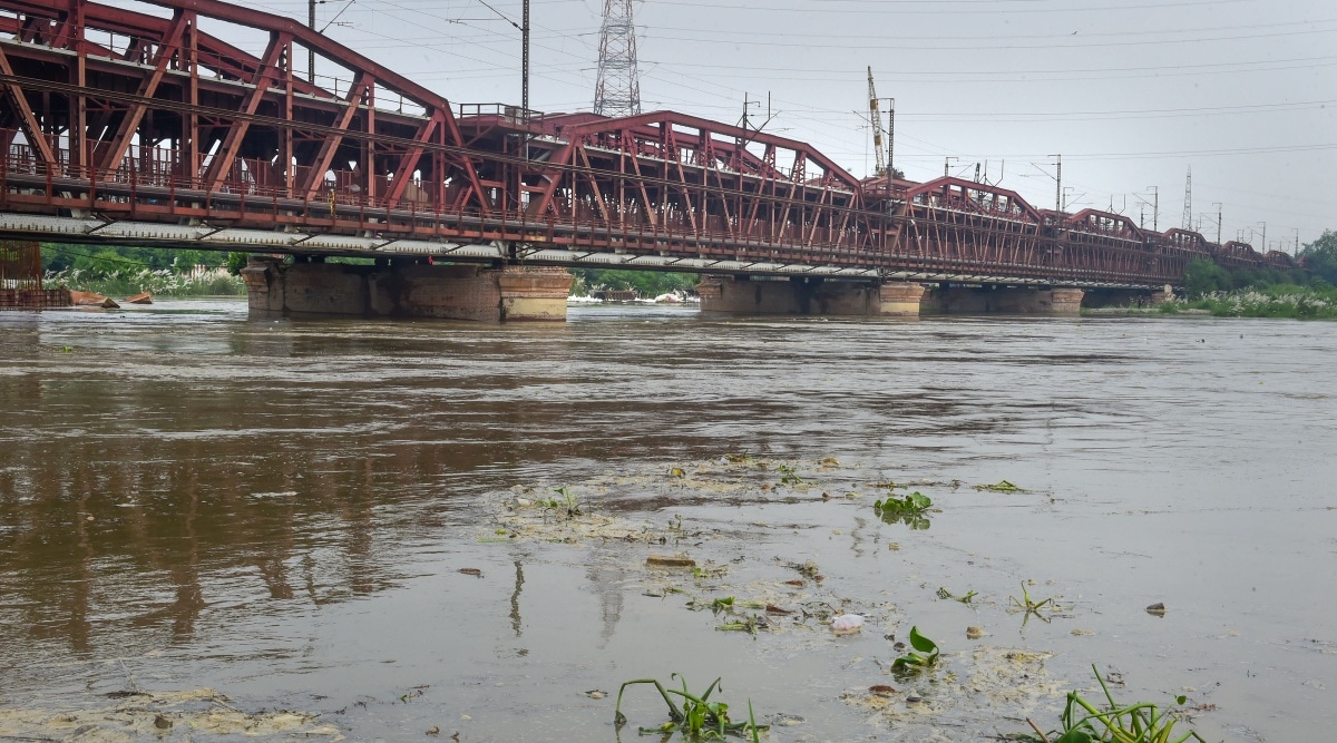
The water level at the Old Railway Bridge was 206.59 metres at 8 am.
The ‘danger’ level is considered to be 205.33 metres. The level at the bridge is likely to reach 206.6 metres by 11 am, according to the Central Water Commission. Read More
IMD predicts generally cloudy sky with light to moderate rain in Bengaluru. Maximum and Minimum temperatures are likely around 28 and 21 degrees Celsius respectively till 29th September 2022.
The ongoing festivities over many parts of Maharashtra, including Pune, could be marred due to cloudy sky conditions and light to moderate intensity rainfall forecast Thursday onwards.
The India Meteorological Department (IMD) has said that gusty winds, lightning and thunder will affect districts of Pune, Ahmednagar, Nashik, Jalgaon, Raigad, Sindhudurg, Ratnagiri, Satara, Sangli, Solapur, Aurangabad, Beed, Latur and Osmanabad till October 1. Read More
A swollen Yamuna flooded low-lying areas along the riverbanks in Delhi, prompting authorities to evacuate hundreds of people and suspend rail traffic movement on the Old Yamuna Bridge.
The water level in the river shot up to 206.38 metres by 7 pm, much above the danger mark of 205.33 metres and the highest since August 2019.
The low-lying areas near the river in Delhi are considered vulnerable to flooding and are home to around 37,000 people. "Most of the people have been shifted to community centres, schools and temporary tents. Nobody is at risk," a senior government official said.
The river breached the danger mark of 205.33 metres in Delhi on Monday night and the evacuation mark of 206 metres early Tuesday morning following heavy rain in the upper catchment areas over the last few days. (PTI)
Durga Puja in Kolkata and southern West Bengal districts is likely to be rain-drenched this year with the Met department saying that a cyclonic circulation may form over northwest Bay of Bengal on October 1.
Regional Met director GK Das said that the system is likely to cause heavy rain in Kolkata and other southern districts on October 2 -- Mahasaptami, the first day of the four-day festival.
"Rainfall is likely on all four days of the festival, with heavier precipitation on October 2 and light to moderate rain till October 5 thereafter," Das said. The cyclonic circulation may intensify after formation on October 1, he said.
The community puja organisers said they are taking all precautions to save the pandals and artwork. (PTI)
The IMD has predicted generally cloudy sky with rain/thundershowers likely in Mumbai and its suburbs for today.
The IMD has predicted generally cloudy sky with light/moderate rain and thundershower in Bengaluru today. Max. and Min. temperatures very likely to be around 28 and 21 degrees Celsius respectively in the city.
An evacuation alert has been declared for people living in the low-lying areas near the Yamuna banks in Delhi with the water level in the river rising to 206.11 metres, well above the danger mark of 205.33 metres and the highest this year so far, following incessant rains in the upper catchment areas, officials said on Tuesday.
East Delhi District Magistrate Anil Banka said the evacuation alert was issued Tuesday morning after the water level crosses the 206-metre mark. (Read More)
Heavy winds and a sudden downpour Monday evening led to massive traffic jams and waterlogging of low-lying areas in certain parts of Hyderabad. The showers that lasted a little more than an hour threw daily life out of gear as roads were covered in water.
The evening showers were accompanied by thunder and lightning, which according to weathermen, will be the scenario in the coming days. Met officials have also forecast heavy rain at isolated places in the coming days across Hyderabad and Telangana. (Read More)
It was a sunny Tuesday morning in Delhi with the minimum temperature settling at 22.4 degrees Celsius, a notch below normal, officials said. The weather office has forecast partly cloudy sky later in the day with the maximum temperature expected to settle around 35 degrees Celsius.
The city recorded a relative humidity of 90 per cent at 8.30 am, according to data shared by the India Meteorological Department (IMD).
The minimum temperature on Monday was recorded at 22.7 degrees Celsius while the maximum temperature stood at 33.4 degrees Celsius. The air quality index (AQI) of Delhi was recorded in the "moderate" (107) category around 9.15 AM, data from CPCB showed.
An AQI between zero and 50 is considered "good", 51 and 100 "satisfactory", 101 and 200 "moderate", 201 and 300 "poor", 301 and 400 "very poor", and 401 and 500 "severe". (PTI)