On September 5, Bengaluru residents woke up to boats being deployed in parts of the city after heavy rainfall lashed the IT capital. The Indian Meteorological Department (IMD) said the city had received 131.6 mm of rainfall in 24 hours, making it the wettest day since 2014.
Visuals of submerged villas and apartments have gone viral on social media. With no way to reach their offices, employees of many companies operating from tech and business parks that were flooded had to work from home. Every August and September, parts of the city are submerged, especially in recent years, with rainfall patterns changing owing to rapid climate change.
But why does Bengaluru go under so often?Understanding the terrain
The city is located on undulated (rising and falling) terrain with continuous valleys that radiate from a ridge across the area. The three major valleys that make up the city are the Hebbal Valley (207 square kilometres), Vrishabhavathi Valley (165 square kilometres) and Koramangala-Challaghatta Valley (255 square kilometres).
Raj Bhagat, a conservation expert, said Bengaluru sits on top of a ridge and is not supposed to flood. Pre-urbanisation, water used to run off the ridge and cascade down the valleys before eventually draining into two major rivers — Kaveri and Ponnaiyar (Dakishina Pinakini) — further away.
A historical perspective
The city's long history is exceptional considering it has no access to any significant perennial water sources. It had to depend on interconnected lakes and rainwater harvesting to meet local demand. An inscription from 1307 CE recorded the construction of a lake in unusual detail — local residents “having cleared the jungle in the tract of land adjoining ‘Peru-Erumur,’ levelled the ground, built a village, constructed a tank by removing the sand, and named the village Vacchidevarapiram.”
"If we go back to the time when the Chola dynasty triumphed over the terrain we know as Bengaluru today, we will see people had already started building tanks and waterbodies in small pockets, for irrigation or other purposes," said Harini Nagendra, an ecologist and author.
Nagendra added that after the Chola dynasty several rulers, including Kempe Gowda, Hyder Ali, Tipu Sultan, the Wodeyar Dynasty and the British slowly took over the area. "However, as more people came into the area, they built more tanks. This continued into the 1890s, when they built the Sankey tank. At that time Colonel Sankey said there are no more places to construct tanks inside the city limits. And also, due to climate fluctuations, there were almost three years of drought. At that time, piped water supply was introduced to the city from the Arkavathi River (a tributary of the Kaveri)," she added.
Sandeep Anirudhan, Convenor of Citizens' Agenda for Bengaluru, said when the city suddenly becomes dependent on external water, the local water supply is gradually neglected. As urbanisation surged, sewage and industrial runoff damaged lakes.
Luxury villas in paddy fields
Fast forward to the 1980s. "I used to live near Cunningham Road, and even then we used to see small incidents of flooding. However, we had wide drainage channels connecting the lakes in the city, through Rajakaluves or stormwater drains carrying the excess water away," said Nagendra.
There used to be acres of wet marshes around the lakes, said Anirudhan. It was an ecologically sensitive area — not just a carbon sink but also a water sink. "When lakes overflowed, the water used to slowly get released as a sponge through the marshes and recharge the groundwater levels," he added.
Several well-known parts of Bengaluru, such as Koramangala and Indiranagar, were marshes once. "This week, we saw waterlogging across several luxury villas. Those areas were paddy fields once," said Nagendra.
Anirudhan said the water flows through the sheets or layers along the topography of the terrain. "This water flows into the lakes recharging them as the wetlands act as water retaining bodies. This also prevents additional water running off across land," he added.
Vishwanath S, former Secretary-General of the International Rainwater Catchment Systems Association, said that as Bengaluru is on a ridge, the water flows over and continues along the contours of the valley. "Water flows from the top side, reaches the river and flows to the sea. In Bengaluru, there is a typical ridge line that divides the terrain in two parts. One part is steeply sloping, towards the Kaveri basin, and the other part is not steeply sloping.Inevitable real estate boom
Bhagat pointed out that due to the growing real estate market, Bengakuru’s valleys have narrowed, and the amount of water they can carry has been reduced.
Anirudhan added that with time, the lands were sold to companies for commercial and residential development. This also narrowed the canal built across the valleys, and further encroachment after 2000 led to this catastrophe, he said.
Dr T.V. Ramachandra, a scientist at the Indian Institute of Science, said that the interconnectivity of lakes has been lost. There has been a 1055 percent increase in concretisation, a loss of 79 percent of water bodies, and 88 percent of vegetation in the last 4.5 decades.
Does the city have warning systems in place?
The Karnataka State Natural Disaster Monitoring Centre (KSNDMC) has installed 134 water-level sensors in flood-prone areas throughout the city.
Speaking to Moneycontrol earlier, Dr Shiv Kumar, Scientific Officer and Hydrologist at KSNDMC, said: “We have collaborated with Space Application Centre, Ahmedabad, and Indian Space Research Organisation (ISRO) to receive daily forecasts. This has been in place for five years now,” he said.
"After the recent floods, currently, we are constructing retaining walls near the stormwater drains so as to increase the water flow and also decrease the number of casualties. Also, we are remodelling the stormwater drains. We hope that we will be able to control the situation within two years," said M Lokesh, Chief Engineer, Bruhat Bengaluru Mahanagara Palike (Stormwater Drain).
So, why does it flood?
Experts say that a good warning system and sensors will help alert officials before the water level rises rapidly. However, to contain the flood, several reforms are needed, including remodelling stormwater drains, something that needs to be evaluated from the micro-level. Researchers also say that stormwater drain capacity should be calculated taking rainfall rates into account.
Vishwanath said the narrative pushed forward today that Bengaluru had a history of no floods is a forced perspective. He said it is a 'romanticised' idea and Bengaluru's infrastructure across history was never meant to contain the flood. It was meant for irrigation 100 years back. We are using the same infrastructure today to contain floods, especially after the stormwater drains and lakes have been encroached. And that's the disaster."
Vishwanath had said previously that the city saw 60 mm per hour of rainfall but today it records up to 200 mm of rainfall per hour. "We have a higher intensity of rains, higher run-off for water but infrastructure that is not designed to take this run-off away. When the stormwater-drain network in the city has not been mapped then how can we remodel stormwater drains?"
“Even a good forewarning system cannot control flooding. We have to design the city in a manner that flooding can be prevented. The prevention aspect has failed due to design defects,” Dr A Ravindra, former chief secretary and former chairman of the Bangalore Development Authority (BDA), told this reporter in an earlier interaction.
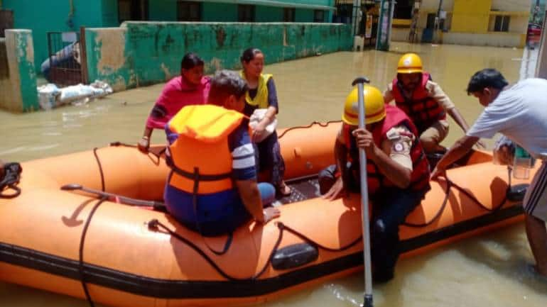 A team of Good Samaritans providing relief work (Credits: Manju Mehra, Namma Team)
Crying for reforms
Chakragiri said the existing stormwater drainage system has to be evaluated right from the micro-level. Researchers also say that stormwater drain capacities should be calculated by taking rainfall rates into account.
Additionally, the problem of floods due to construction that violates buffer zones should be addressed through an appropriate combination of structural designs, such as watershed treatment, where channels carrying water to the tanks are unobstructed and maintained properly, and non-structural methods, such as warning systems and citizen awareness, that are implemented well, he said. Experts say development is inevitable, and there is a need to look at water recharge pits across the city so that groundwater can be recharged.
Ramachandra said not just infrastructural reforms, the rapidly changing climate across the globe needs to be factored in.
Previously, Dr Indu K Murthy, Sector Head in the Climate, Environment and Sustainability team at the Centre for Study of Science, Technology and Policy, had told Moneycontrol that every city needs to have a climate action plan taking at least 30 years into consideration.
Data needs to be in the public domain
In the absence of any public data on the city's drainage structure, most researchers have failed to analyse the solution critically.
"Having it in the public domain will help researchers critically analyse data and find more solutions," said Harini.
What is the BBMP’s argument? Talking to this reporter earlier, Chief Engineer Lokesh had said: “Publishing data will invite more criticism from the public. BBMP will make the data available to researchers upon request.”