Top Searches
- News
- City News
- bengaluru News
- Rain++: Is there a code to fix tech capital’s mess?
Rain++: Is there a code to fix tech capital’s mess?
ARTICLES

Rain++: Is there a code to fix tech capital’s mess? Boman Irani and these creators reveal how to get a 5% cashback every time you shop online, with the all-new CASHBACK SBI Card. It’s #NotAHack Karnataka CM Basavaraj Bommai seeks special funds from Centre Bengaluru: Guard electrocuted in basement

Floods in Bengaluru did not spare even the super rich
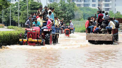
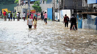
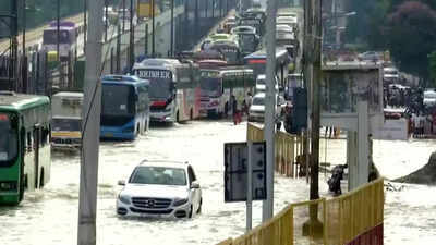
A deluge of woes engulfing India’s premier tech city in the past few days has tellingly revealed its shortcomings in handling heavy rains and exposed the gaps in its infrastructure, planning and enforcement.
First, let’s look at the major areas affected in the past 10 days. While there have been reports of brief inundation and stray flooding of homes from across the city, the most significant impact has been in the east, southeast and northeast parts.
The Mahadevapura zone comprising Hoodi, Garudacharpalya, Kadugodi, Doddanekkundi, Marathahalli, Varthur and Bellandur – which together host dozens of info-tech parks from around the year 2000 -are among the areas particularly hit hard. From slums and workers’ colonies to upscale gated communities and tech parks, the current floods have been unsparing and indiscriminate.
The weatherman has predicted more rainfall this week.
Why the flooding?
Immediate Villain: Unprecedented rainfall has been the immediate trigger. While Bengaluru was expected to receive a normal rainfall of around 3cm between September 1 and 6, the city was battered with a whopping 13cm rainfall in the six-day period. The already-overflowing lakes had no space to accommodate more water, following which roads, tech parks and residential layouts turned into lakes.
Shrinking Lakes And Drains: Lakes interconnected with canals and drains constitute the basic storm water collection systems for any city. However, rapid urbanization and increasing land demand have led to uncontrolled developmental activities in lakes’ neighborhood, further resulting in encroachment of lakes and storm water drains (SWDs).
The latest CAG audit, which examined stormwater drain management, cites an IISc report to say: “From 1,452 waterbodies with a storage capacity of 35tmcft of water during the early 1800s, waterbodies in Bengaluru dipped to 194 with storage capacity of 5tmcft by 2016. The current storage capacity has further declined due to siltation and is 1. 2tmct,” it reads. Of the 210 lakes under the custody of BBMP as of December 2020, at least 18 lakes (spread over 254 acres) were disused, making them vulnerable to encroachments and future conversions. Besides, dumping of waste and debris in SWDs, and lake catchment also affect the city’s ability to handle even a slight increase in rainfall. Loss of interconnectivity between water bodies also adds to the problems.
Land Use: As per another IISc study, the built-up area (concretisation) in Bengaluru is estimated to have increased by more than 1,000% since the 1970s. From about 8% in 1973, it was at 93. 3% at the end of 2022. Increase in concretisation and impervious layer result in an increase of stormwater runoff. Higher the runoff, more the flooding.
And the blame goes to…
Successive governments and citizens must share the blame for Bengaluru’s water woes.
Poor planning, lack of vision (the government itself has allowed conversion of many lakes for residential purposes, approved plans for construction on lakebeds, SWDs, not maintained water bodies and so on) and enforcement point fingers at the government. However, citizens, too, are guilty of encroachments, pollution of waterbodies and SWDs, illegal constructions and more.
5-point guide to clear the slush
1. The government should formulate a comprehensive policy which clearly recognizes urban runoff as a potential source of water requiring a clear plan of action for conservation.
2. City civic administration body, Bruhat Bengaluru Mahanagara Palike (BBMP) must prevent further reduction in waterbodies and length of the natural drains and ensure inter-connectivity of waterbodies for proper conservation of the ecosystem as well as ground water.
3. BBMP and water supply management board BWSSB should jointly prepare a plan of action to prevent sewage flow into SWDs; implementation should be monitored by the Karnataka government.
4. Government and city development authority BDA (Bangalore Development Authority) should take immediate action to finalise and notify revised ‘masterplan’ to prevent encroachments of waterbodies and rectify the omissions with regard to SWDs.
5. BBMP must prepare a comprehensive database of SWDs in coordination with other agencies to serve as a single source for effective planning and management of SWDs.
FOLLOW US ON SOCIAL MEDIA
FacebookTwitterInstagramKOO APPYOUTUBE
Start a Conversation
end of article


FOLLOW US ON
Popular Categories
Hot on the Web
Top Trends
Coronavirus in India LiveRussia Ukraine War LiveOnam 2022Bangalore FloodsNCVT Result 2022Central Vista Project InaugurationPakistanvs AfghanistanCongress Bharat Jodo Yatra LiveICC20i RankingsNEET Result 2022Stock MarketIndia Covid CasesCyrus Mistry DeathKatra EarthquakeDr Bhupen HazarikaGanesh Chaturthi Celebrations LiveCryptocurrency Price in IndiaHoroscope Today
Trending Topics
Sushmita SenGenelia D'souzaAlia BhattAngelina JoliPankaj Tripathi Favourite RecipeJennifer WingetRashmika MandannaCaptain ReviewKatrina KaifMouni RoySouth Actresses Onam LookShweta TiwariBeachside Hotel In IndiaOnam 2022Bowel Cancer SymptomsNayantharaVivo Y55sLaptops under 30000WiFi RoutersTablets under 15000
Living and entertainment
Copyright © 2022 Bennett, Coleman & Co. Ltd. All rights reserved. For reprint rights: Times Syndication Service