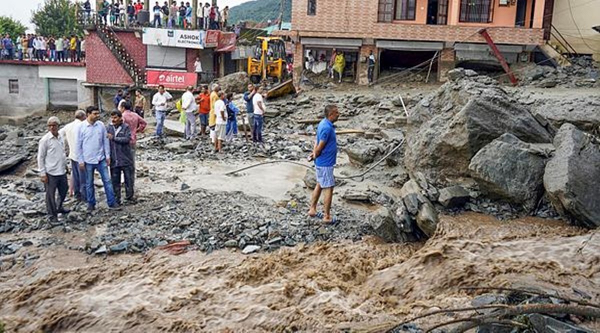
 Top India News Latest Updates: Locals at a damaged residential area after flash floods triggered by a cloudburst at Khaniara, in Dharamshala, Friday. (PTI)
India Weather Live Today: Senior officials visited Khaniyara locality here on Saturday, a day after a cloudburst triggered a flash flood in the area, and directed relief workers to step up efforts for rehabilitation of those affected.
Several houses and shops were destroyed in heavy rains in the area on Friday. Besides, 15 houses and three shops were partially damaged and 45 sheep and goats went missing.
Meanwhile, the Indian Meteorological Department (IMD) predicted heavy rainfall spell over extreme south Peninsular and northeast India for the next five days and over Bihar, Jharkhand and Sub-Himalayan West Bengal and Sikkim during the next three days. Subdued rainfall activity was predicted over plains of northwest India and over Central India during the next 5 days. Isolated very heavy rainfall is also likely to occur over Arunachal Pradesh, Assam and Meghalaya today. Fairly widespread rainfall with isolated heavy falls and thunderstorm/lightning very likely over Chhattisgarh, coastal Karnataka, north interior Karnataka, Rayalaseema, Lakshadweep, Tamil Nadu, Kerala and Mahe till September 6.
Major regions across the country will receive normal to above normal rainfall in September, the IMD said on Thursday. According to the forecast, the southwest monsoon is unlikely to start withdrawing anytime soon. Quantitatively, the all-India rainfall for September is forecast to be 109 per cent of the Long Period Average (LPA), which is 168.9mm (1971-2020). Jammu, Punjab, Himachal Pradesh, Uttarakhand, Delhi, Haryana, Rajasthan, Gujarat, Madhya Pradesh, southwest Uttar Pradesh, Maharashtra, Telangana, north Andhra Pradesh, coastal Karnataka, north Kerala, south coastal Tamil Nadu, Tripura and the Andaman and Nicobar Islands will receive normal to above normal rainfall this month, IMD said.

The IMD has predicted:
- Isolated heavy falls and thunderstorm/lightning very likely over Jammu & Kashmir on 04th;
- Isolated heavy falls and thunderstorm/lightning very likely Himachal Pradesh on 03rd & 04th
- Isolated heavy falls and thunderstorm/lightning very likelyUttarakhand during 03rd-05th September, 2022
-Isolated very heavy rainfall also likely over Uttarakhand on 04th September, 2022.
The IMD has predicted isolated heavy falls and thunderstorm/lightning very likely over Arunachal Pradesh, Assam & Meghalaya and Nagaland, Manipur, Mizoram & Tripura during next 4 days.
Over the past three months, two out of the nine districts that the India Meteorological Department (IMD) considers for rainfall data in Delhi have recorded a ‘large deficit’ in rainfall, while five districts have recorded a ‘deficit’. Northeast Delhi and West Delhi have both recorded a large deficit of 60 per cent in rainfall from June 1 to September 2, the IMD data shows. Rainfall that is 60 per cent to 99 per cent below the normal is considered a “large deficit”.
The districts that have recorded a deficit (20% to 59% short of the normal) in rainfall over the same time period are New Delhi, North Delhi, Northwest Delhi, South Delhi and Southwest Delhi. (Read More)
Senior officials visited Khaniyara locality here on Saturday, a day after a cloudburst triggered a flash flood in the area, and directed relief workers to step up efforts for rehabilitation of those affected.
Several houses and shops were destroyed in heavy rains in the area on Friday. Besides, 15 houses and three shops were partially damaged and 45 sheep and goats went missing
Kangra Deputy Commissioner Nipun Jindal visited Khaniyara along with Superintendent of Police Kushal Sharma this morning.
Jindal instructed the relief workers to expedite efforts for the rehabilitation of those affected due to the heavy rains so that they do not face any problems.
"The damage caused by the rains is being reviewed and effective steps are being taken by the district administration to ensure that the affected families do not face any kind of problem," Jindal said.
Due to the heavy rain on Friday, a nullah in Khaniyara village overflowed, damaging private and public property in the main market.
Mud entered houses and shops on the Nag Mandir road and a small bridge was washed away, affecting traffic on the Dharamshala-Sidhwari road. A few vehicles were also damaged in the flash flood. PTI
Over the past three months, two out of the nine districts that the India Meteorological Department (IMD) considers for rainfall data in Delhi have recorded a ‘large deficit’ in rainfall, while five districts have recorded a ‘deficit’. Northeast Delhi and West Delhi have both recorded a large deficit of 60 per cent in rainfall from June 1 to September 2, the IMD data shows. Rainfall that is 60 per cent to 99 per cent below the normal is considered a “large deficit”.
The districts that have recorded a deficit (20% to 59% short of the normal) in rainfall over the same time period are New Delhi, North Delhi, Northwest Delhi, South Delhi and Southwest Delhi. Read more.
The national capital woke up to a generally cloudy sky on Saturday, recording a minimum temperature of 26.8 degrees Celsius, one notch above the normal for the time of the year, an India Meteorological Department (IMD) bulletin said.
The maximum temperature is expected to settle at 38 degrees Celsius, it said.
According to the bulletin, there will be a cloudy sky throughout the day.
The relative humidity recorded at 8.30 am was 40 per cent, the bulletin said.
The air quality index (AQI) of Delhi was recorded in the moderate (106) category around 9 am, data from the System of Air Quality and Weather Forecasting And Research (SAFAR) showed.
An AQI between zero and 50 is considered good, 51 and 100 satisfactory, 101 and 200 moderate, 201 and 300 poor, 301 and 400 very poor, and 401 and 500 severe.PTI
Karnataka Chief Minister Basavaraj Bommai blamed problems like waterlogging in the IT corridor in southeast Bengaluru on the “neglect” of the city over the past eight to 10 years and under previous governments, after a visit to the corridor on Thursday.
“In the last eight to 10 years, Bengaluru has been completely neglected. Around six or seven years ago, all the problems of the city could have been solved. There were no major problems at the time. It could have been done. It was not done,” Bommai said at a meeting with local leaders and officials in the information technology corridor. Read more.
Light to moderate rain at many places with isolated thunderstorms and lightning is likely to occur over Tamil Nadu, Puducherry, and Karaikal. Heavy rain is likely to occur at isolated places over Nilgiris, Coimbatore, Tiruppur, Theni, Dindigul, Erode, Salem, Dharmapuri, Krishnagiri, Tirupattur, Vellore, Ranipet, and Tiruvannamalai.
More from India
Odisha is likely to get relief from the week-long hot and humid weather, caused by the monsoon's weakening trend, as the IMD on Friday forecast the creation of two back-to-back low pressure areas over Bay of Bengal in the next two weeks.
The first is expected to develop over West-Central Bay of Bengal and adjoining northwest Bay of Bengal by September 8, and the second between September 9 and 15, said US Dash, a senior weather scientist at the Regional Meteorological Centre, Bhubaneswar.
Dash said that rainfall activity might intensify in the state from September 5.
"Odisha is currently experiencing hot and humid weather due to weakening of the monsoon. Most places in the state have recorded maximum temperature at or above 35 degree Celsius, with humidity exceeding 80 per cent in some areas since Thursday," he stated.
The twin cities of Bhubaneswar and Cuttack recorded over 35 degree Celsius throughout the week.
The IMD, meanwhile, also said that the seasonal cumulative rainfall received by Odisha between June 1 and September 2 stood at 992 mm against its usual average of 931.9 mm.
During the period, six districts received excess rainfall.
According to the midday IMD bulletin, heavy rainfall is likely at one or two places in Gajapati, Ganjam, Puri, Khurda, Kandhamal, Rayagada, Kalahandi and Nabarangpur on September 6. PTI
Good morning! Welcome to today's live blog. We bring to you all the latest weather updates from across India.