 India Weather Today Live Updates August 8. (File photo)
India Monsoon News Live Updates, Weather News Update, Rain News Live Today, August 7, 2022: Odisha and neighbouring West Bengal are likely to receive heavy rainfall over the next two to three days, due to a depression that is set to take shape over the Bay of Bengal, the Met office said. Fishermen have been advised not to venture off the coast till Thursday morning, as squally weather with wind speed of 45-55 kmph and gusting up to 65 kmph is very likely over northwestern Bay of Bengal. The weatherman issued an ‘orange warning’ of heavy to very heavy rain in the districts of Khurda, Puri, Rayagada, Kalahandi, Gajapati, Ganjam, Nayagarh, Kandhamal, Nabarangpur, Malkangiri and Koraput for Monday. (PTI)
Meanwhile, The India Meteorological Department has issued a “red” alert to Pune and parts of western Maharashtra including, Raigad, Ratnagiri, Satara. An active monsoon will cause extremely heavy rainfall and lead to squally winds off the eastern India coast during the next three days. The IMD has placed Odisha and Telangana on ‘red’ alert.
In other news, pre-empting an increase in the Yamuna water level amid rain, the Northeast Delhi district magistrate has asked Delhi Police to increase police deployment round-the-clock around flood-prone areas. Officials said that all districts have also prepared district-wise disaster management plans for evacuation and to prevent incidents like fire emergencies and flooding.
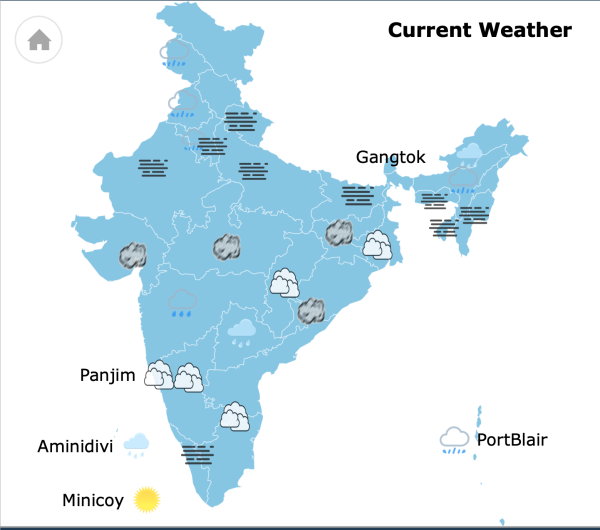 Weather update as of August 8, 8:22 am.

At least 14 cars were swept away while around 50 people ran for safety to higher places in a forest in Madhya Pradesh's Khargone district due to sudden rise of water in a river after rains, police said on Monday.
The people, including women and children, all from Indore district, were on Sunday evening enjoying a picnic near the Sukdi river in Katkoot forest under Balwada police station limits, Additional Superintendent of Police Jitendra Singh Pawar said.
Following rains in the area, the river water level suddenly rose. (PTI)
The India Meteorological Department (IMD) forecast very light rainfall for Delhi on Monday and a few days of the week ahead.
Tuesday and Wednesday are likely to remain dry, while very light rainfall returns to the forecast on Thursday. There is no rain in the forecast for Friday and Saturday, though cloudy skies may persist.
The minimum temperature early on Monday was 25.1 degrees Celsius, two degrees below normal. The maximum temperature on Monday is likely to settle at 33 degrees Celsius. Read more.
Two children in Karnataka's Ramanagara district died after a part of a wall of a cowshed collapsed on their house following heavy rains in the early hours of Sunday.
The deceased are Parbeen Sunak (4) and his cousin Ishika (3). Monisha and her daughter-in-law Meena have escaped with minor injuries.
The weather department has issued a yellow alert for heavy rainfall in many districts of Rajasthan for the next three days.
It has forecast torrential rains along with thunderstorms in Ajmer, Bhilwara, Bundi, Chittorgarh, Dungarpur, Jhalawar, Kota, Pratapgarh, Sawai Madhopur, Sirohi, Tonk, Udaipur and Pali districts for the next three days. Read more.
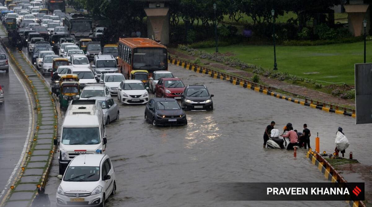
A spell of rain for over two hours left several parts of the city waterlogged and led to traffic congestion in Gurgaon Sunday morning.
Traffic police officials said waterlogging was reported at Subhash Chowk, near the Huda City Centre Metro Station, Signature Tower, Manesar bus stand, Hanuman Chowk, Sector 4/5 Chowk, Krishna Chowk, Sector 21/22 road, near Wazirabad traffic signal, AIT Chowk, Kanhai Chowk, near Mayfield Garden Chowk, Artemis Chowk, South City 1, Iffco Chowk, and several stretches of National Highway 48. Read more.
More from India
Parts of South Delhi, as well as Gurgaon, received heavy rain Sunday morning, with several key roads reporting waterlogging, even as the India Meteorological Department (IMD) predicted moderate rain across the Capital during the day.
The city did not see any rain between 8.30 am on Saturday and 8.30 am on Sunday. After that, Palam, Ayanagar, and Pusa Road witnessed a heavy downpour.
At Palam, 32 mm of rain was witnessed in the three hours between 8.30 am and 11.30 am. At Pusa Road, 21 mm of rainfall was seen and 20 mm was recorded in Ayanagar. Safdarjung (2.4 mm), Lodhi Road (1.2 mm), and Ridge (1.4 mm) saw only light rain in the same period. Read more.
Rainfall forecast available as on August 7 valid till ending at 08:30 am of August 8:
State: Widespread moderate to very heavy rains likely over Coastal Karnataka districts and widespread very light to moderate rains with isolated heavy to very heavy rains likely over Malnad districts. Widespread light to moderate rains and isolated places heavy rains likely over NIK districts and scattered to widespread very light to moderate rains likely over SIK districts.
Thunderstorms with lightning activity likely over isolated places of the State.
Scattered to widespread light to moderate rains likely over Kolar, Bengaluru Rural, Bengaluru Urban, Tumakuru Davanagere and Ramanagara districts and isolated to scattered very light to moderate rains likely over remaining districts of the region.
Widespread light to moderate with isolated heavy rains likely over Kalaburgi, Vijayapura, Yadgir and Raichur districts. Scattered to widespread very light to moderate rains likely over remaining districts.
Malnad: Widespread very light to moderate rains with isolated heavy to very heavy rains likely over Kodagu, Hassan, Chikkamagaluru and Shivamogga districts.
Coastal: Widespread moderate to very heavy rains likely over Dakshina Kannada, Udupi and Uttara Kannada districts.
Rainfall forecast for BBMP area as on August 7 valid till ending at 08:30 am of August 8:
Widespread very light to moderate rains likely over BBMP area. Maximum and minimum temperatures likely to be around 26 and 20 degree C respectively.
Waterlogging reported in several areas including Subhash Chowk, AIT chowk, South City 1 and the service lane on national highway 48 after a spell of rain in Gurgaon.
The Bengaluru meteorological centre predicted a generally cloudy sky. The city and its suburbs will expereince light to moderate R=rain/thundershowers very likely. The maximum and minimum temperatures are very likely to be around 26 and 20
degree Celsius respectively.
Bengaluru city recorded 3.7 mm rainfall until August 7, 8 am.
Bengaluru International airport recorded 0.6 mm rainfall and Bengaluru HAL airport recorded 2.7 mm rain.
The IMD has predicted that intense rainfall activity will likely continue over South and Coastal Karnataka, Konkan and Goa, Odisha for the next 5 days. Konkan and Goa coast to witness rain from August 8 to 10 and Odisha on August 8 and 9. Intense rainfall activity likely to commence over Vidarbha today and over Gujarat, West Madhya Pradesh and Gangetic West Bengal from August 8. Extremely heavy rainfall to hit Madhya Maharashtra from August 8 to 10. Rain to begin in Telangana and Chhattisgarh on August 8.
Good morning! Welcome to today's Monsoon blog. We bring to you all the latest rain updates from across India.