- News
- City News
- guwahati News
- Tupul a disaster waiting to happen? Jury’s out
Tupul a disaster waiting to happen? Jury’s out

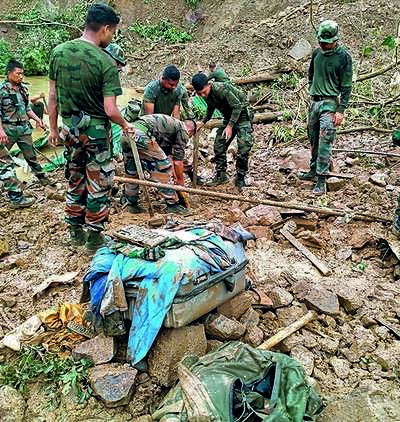
Guwahati: As the body count keeps climbing after the killer landslide struck at Tupul in Manipur’s Noney district, the question now is whether the devastation was due to man-made reasons or nature’s fury.
The country’s nodal agency for landslide studies, Geological Survey of India (GSI), carried out a study in parts of Noney and Tamenglong districts in 2018-19. It said one of the interesting and notable slides in the area is Tupul village which shifted towards NH-37 induced by the 2016 earthquake whose epicentre was in Kabui Khullen in the north of the area. “The village of Tupul is located on the bank of Ijai river surrounded by steeper slopes. Tupul is located on low susceptible class surrounded by moderate to high susceptible slope,” the report said.
While it may take some time to pinpoint the exact cause of the Tupul incident, the GSI had found that out of 170 landslides that occurred between 2011 and 2017, “most have occurred in extensive slope cut during construction of road/railway line. Out of 170 recorded slides, only 30 slides were on natural slopes and the rest were of anthropogenic origin.”
“Landslides caused under natural conditions vary in sizes and constitute about 76% of the inventory and the remaining 24% caused by anthropogenic activities like slope cutting for road and railway line,” the report added.
The GSI report said even “railway is at risk’ on NH-37, Imphal-Jiribum highway, because of “cutting of slope for railway line and increase in pore water pressure reducing the cohesive strength of the overburden materials”.
The railways are constructing a 111-km rail connectivity from Jiribam to Tupul and the landslide on the intervening night of Wednesday and Thursday struck the under-construction Tupul railway yard and the post of 107 Bn of Territorial Army, which was stationed there for securing the railway project.
The report had then underlined that the 24-km Noney-Maranching road is mostly located along moderately to high susceptible slopes. “Slope cutting for railway is being carried out extensively above the road stretch causing most of the landslides. Geologically it is underlain by flaggy sandstone with subordinate shale of Laisong Formation and shales of Disang Formation. The road stretch runs parallel to Tupul fault, Kharam fault and Pangsang fault.”
“In recent times due to government schemes, the area has a number of road constructions and railway cutting. Huge number of landslides was collected from these roads and they were not necessarily due to extensive slope cuts. Some were deep gully erosion due to blockade of natural nala course by road construction. The roads are also unmetalled without any proper lined drainage on the sides and proper culverts and are accessible only during dry season. Due to these anthropogenic activities, the landslides are distributed along all the susceptibility classes,” the report said.
FOLLOW US ON SOCIAL MEDIA
FacebookTwitterInstagramKOO APPYOUTUBE

Start a Conversation
end of article


FOLLOW US ON
Popular Categories
Hot on the Web
Top Trends
Coronavirus in India LiveRussia Ukraine War News LiveIndia Covid CasesMaharashtra Floor Test LiveNupur SharmaPM ModiDevendra FadnavisEknath ShindeUmesh KolheIndia vs England Live ScoreNTPCKullu Bus AccidentCBSE 10th Result 2022Ankit SirsaStock MarketPSEB 10th Result 2022Cryptocurrency Price in IndiaHoroscope Today
Trending Topics
Living and entertainment
Copyright © 2022 Bennett, Coleman & Co. Ltd. All rights reserved. For reprint rights: Times Syndication Service