- News
- City News
- thiruvananthapuram News
- 1,252 schools, 113 hospitals in Kerala exposed to floods: Data
1,252 schools, 113 hospitals in Kerala exposed to floods: Data

 in association with the UNEP - File Photo")
The data was prepared by the Kerala state disaster management authority (KSDMA) in association with the UNEP - File Photo
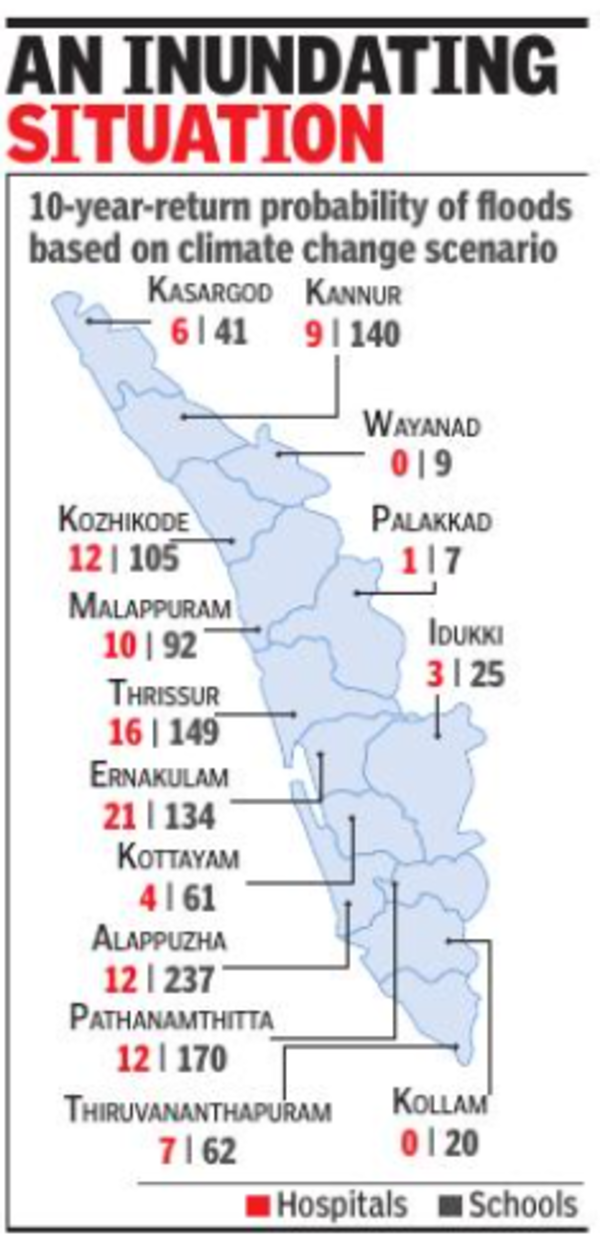
THIRUVANANATHAPURAM: A probability chart of the number of schools and hospitals in the state that are exposed to floods has found that 1,252 schools and 113 hospitals are exposed to floods, having a flood return probability of once in 10 years. The data was prepared by the Kerala state disaster management authority (KSDMA) in association with the United Nations Environment Program (UNEP).
The maps are relevant in the wake of a recent report by the Intergovernmental Panel on Climate Change (IPCC) that has predicted serious impact of climate change on the state and the unpredictable climatic patterns seen in the state's climate cycle in recent years, especially since 2018.
 As per data, Alappuzha has the highest probability of flood returns in the once in 10-year category, with 12 hospitals and 237 schools exposed to floods, while the number is the least in Wayanad and Palakkad, where there are no hospitals and only nine schools and one hospital and seven schools, respectively, in this category.
The chart has been prepared both based on historical data available and also based on climate change scenarios. As per historical data, there are six hospitals and 132 schools in Alappuzha that would come under the flood return probability of once in 10 years. In Wayanad and Palakkad there are only four schools in this category.
"The data prepared based on the climate change scenario is the worst case and would be used for perspective planning, while the historical data are more realistic and will be used for disaster management plans," KSDMA sources said. As per historical data, there are 536 schools and 48 hospitals under the flood return probability of once in 10 years.
The charts for flood return possibilities once in 25, 50, 100, 200 and 500 years have also been prepared as part of the initiative. The local self-government department (planning) and Kerala institute of local administration (KILA) are now engaged in the process of using this data for preparing risk-informed planning for individual local bodies in the state. "Local bodies in the state already have a master plan. Going a step ahead, we have decided to improve the master plan by incorporating the flood exposure data. As a pilot project, it has been done for Chengannur and Mananthavady municipalities. In the next phase, it will be done for nine municipalities in four districts, which are covered by the Pamba river, including Pathanamthitta, Alappuzha, Kottayam and Idukki," KILA director Joy Elamon said.
The maps are relevant in the wake of a recent report by the Intergovernmental Panel on Climate Change (IPCC) that has predicted serious impact of climate change on the state and the unpredictable climatic patterns seen in the state's climate cycle in recent years, especially since 2018.
The chart has been prepared both based on historical data available and also based on climate change scenarios. As per historical data, there are six hospitals and 132 schools in Alappuzha that would come under the flood return probability of once in 10 years. In Wayanad and Palakkad there are only four schools in this category.
"The data prepared based on the climate change scenario is the worst case and would be used for perspective planning, while the historical data are more realistic and will be used for disaster management plans," KSDMA sources said. As per historical data, there are 536 schools and 48 hospitals under the flood return probability of once in 10 years.
The charts for flood return possibilities once in 25, 50, 100, 200 and 500 years have also been prepared as part of the initiative. The local self-government department (planning) and Kerala institute of local administration (KILA) are now engaged in the process of using this data for preparing risk-informed planning for individual local bodies in the state. "Local bodies in the state already have a master plan. Going a step ahead, we have decided to improve the master plan by incorporating the flood exposure data. As a pilot project, it has been done for Chengannur and Mananthavady municipalities. In the next phase, it will be done for nine municipalities in four districts, which are covered by the Pamba river, including Pathanamthitta, Alappuzha, Kottayam and Idukki," KILA director Joy Elamon said.
FOLLOW US ON SOCIAL MEDIA
FacebookTwitterInstagramKOO APPYOUTUBE

Start a Conversation
end of article


FOLLOW US ON
Popular Categories
Hot on the Web
Top Trends
Coronavirus in India LiveRussia Ukraine War News LiveIndia Covid CasesDevendra FadnavisMaharashtra Political CrisisUddhav ThackerayVice President Election 2022TS SSC Results 2022Assam FloodFloor Test in MaharashtraUdaipur Tailor DeathBihar Politics NewsMaruti Suzuki Brezza 2022Mohammed ZubairGST Council MeetingHPBOSE 10th Topper 2022Cryptocurrency Price in IndiaHoroscope Today
Trending Topics
Living and entertainment
Copyright © 2022 Bennett, Coleman & Co. Ltd. All rights reserved. For reprint rights: Times Syndication Service