Top Searches

- News
- City News
- delhi News
- Delhi-NCR weather: Summer's 1st big rain relief; Monday coolest in 72 days
Delhi-NCR weather: Summer's 1st big rain relief; Monday coolest in 72 days


A newly repaired road caved in due to rain at Gurgaon’s IFFCO Chowk
NEW DELHI: Delhi-NCR received its first spell of heavy rain since February this year, with some stations in the city recording over 50mm in less than 24 hours, bringing much-needed relief from searing heat as the maximum temperature plummeted by eight degrees from Sunday and as much as 11 degrees since two days ago.
Aided by overnight rains, Delhi experienced its coolest May night in 18 years, with the minimum temperature at Safdarjung dipping to 17.2 degrees Celsius, the lowest for the month since 2004. The maximum, at 31.5 degrees C, was the lowest since 2014 barring last year, which witnessed an unusually wet and cool May. This was also the coolest day in Delhi in 72 days since March 12, when the maximum temperature was last below 31.5 degrees.

However, the day wasn't so cool for commuters and the city's green cover. Waterlogging and traffic snarls were reported on major stretches such as Rao Tula Ram flyover, ITO, Preet Vihar and ISBT. The Pul Prahladpur rail underpass was inundated and had to be shut. The disruptions were a lot worse in Gurgaon, from where a road cave-in was also reported.
With the rain accompanied by winds gusting up to 75-80 kmph, over 100 flights were delayed and 20 had to be diverted. Some 100 trees were uprooted in the capital and 150 in Gurgaon, as per the respective civic bodies.
But, for a majority of the region's residents, the wet spell came as a major relief from heat and a prolonged dry spell. The city had last received heavy showers in February, nearly three months ago.
Met dept predicts respite from heatwave for 7 days
The heavy thunderstorms and strong winds seen in Delhi-NCR on Monday are not uncommon between March and June, but this season had been different, weather scientists said.
Many parts of the city and NCR received another spell of rain late on Monday. The met department said Tuesday could see some more rain of lesser intensity.
Gurgaon received as much as 74.4mm of rainfall from Sunday till 5.30pm on Monday. Ayanagar in Delhi recorded 55.4mm, Najafgarh 34mm and Palam 29.2mm. Safdarjung received 12.3mm till 5.30pm and 3.8mm more till 11.30pm.
"Thunderstorms and a western disturbance are the major reasons behind the intense rainfall and winds which reached up to 80 kmph in some parts. Such events are not uncommon during this season," said R K Jenamani, senior weather scientist at IMD.
Weather analysts stated that the strong rainfall and winds happened due to a combination of different events. "The intense weather events on Monday were led by a combination of reasons including strong western disturbance, high moisture retention in the air due to moist winds from Bay of Bengal, cyclonic circulation over north-west Rajasthan and extension of low pressure line of trough from north-west Rajasthan and southern West Bengal," said Mahesh Palawat, vice-chairman, Skymet.
Western disturbance (WD) is flow of moisture-laden winds from the Mediterranean Sea region to the Himalayas that forms a low-pressure area over the region and sometimes leads to rain and snow in northern India.
The minimum temperature of 17.2 degree Celsius at Safdarjung was as much as nine notches below normal while the maximum (31.5 degree C) was eight degrees less than normal.
The weather department has forecast respite from heatwave for at least the next seven days.
"The peak of the thunderstorm is now over, though one or two light to moderate level thunderstorm may occur this season. The temperature may rise but there will be no heatwave for next week," Jenamani added.
The maximum and minimum temperature on Tuesday is likely to hover around 34 and 19 degree Celsius respectively, along with strong winds up to 30-40 kmph.
Meanwhile the air quality of the city improved to moderate category. The air quality index (AQI), on a scale of 0 to 500, on Monday was 136, against 203 a day earlier. "AQI today improved significantly. Dust contributed to approx. 68% to PM10. This improvement was due to wet deposition of pollutants by today morning rain. For the next 3 days (24th, 25th, 26th) peak wind speed is likely to be 18-30 km/h causing strong dispersion and AQI is likely to be within 'moderate' or 'upper end of satisfactory' due to likelihood of more rain spell," said a statement from SAFAR.
Aided by overnight rains, Delhi experienced its coolest May night in 18 years, with the minimum temperature at Safdarjung dipping to 17.2 degrees Celsius, the lowest for the month since 2004. The maximum, at 31.5 degrees C, was the lowest since 2014 barring last year, which witnessed an unusually wet and cool May. This was also the coolest day in Delhi in 72 days since March 12, when the maximum temperature was last below 31.5 degrees.
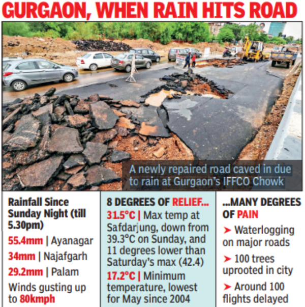
However, the day wasn't so cool for commuters and the city's green cover. Waterlogging and traffic snarls were reported on major stretches such as Rao Tula Ram flyover, ITO, Preet Vihar and ISBT. The Pul Prahladpur rail underpass was inundated and had to be shut. The disruptions were a lot worse in Gurgaon, from where a road cave-in was also reported.
With the rain accompanied by winds gusting up to 75-80 kmph, over 100 flights were delayed and 20 had to be diverted. Some 100 trees were uprooted in the capital and 150 in Gurgaon, as per the respective civic bodies.
But, for a majority of the region's residents, the wet spell came as a major relief from heat and a prolonged dry spell. The city had last received heavy showers in February, nearly three months ago.
Met dept predicts respite from heatwave for 7 days
The heavy thunderstorms and strong winds seen in Delhi-NCR on Monday are not uncommon between March and June, but this season had been different, weather scientists said.
Many parts of the city and NCR received another spell of rain late on Monday. The met department said Tuesday could see some more rain of lesser intensity.
Gurgaon received as much as 74.4mm of rainfall from Sunday till 5.30pm on Monday. Ayanagar in Delhi recorded 55.4mm, Najafgarh 34mm and Palam 29.2mm. Safdarjung received 12.3mm till 5.30pm and 3.8mm more till 11.30pm.
"Thunderstorms and a western disturbance are the major reasons behind the intense rainfall and winds which reached up to 80 kmph in some parts. Such events are not uncommon during this season," said R K Jenamani, senior weather scientist at IMD.
Weather analysts stated that the strong rainfall and winds happened due to a combination of different events. "The intense weather events on Monday were led by a combination of reasons including strong western disturbance, high moisture retention in the air due to moist winds from Bay of Bengal, cyclonic circulation over north-west Rajasthan and extension of low pressure line of trough from north-west Rajasthan and southern West Bengal," said Mahesh Palawat, vice-chairman, Skymet.
Western disturbance (WD) is flow of moisture-laden winds from the Mediterranean Sea region to the Himalayas that forms a low-pressure area over the region and sometimes leads to rain and snow in northern India.
The minimum temperature of 17.2 degree Celsius at Safdarjung was as much as nine notches below normal while the maximum (31.5 degree C) was eight degrees less than normal.
The weather department has forecast respite from heatwave for at least the next seven days.
"The peak of the thunderstorm is now over, though one or two light to moderate level thunderstorm may occur this season. The temperature may rise but there will be no heatwave for next week," Jenamani added.
The maximum and minimum temperature on Tuesday is likely to hover around 34 and 19 degree Celsius respectively, along with strong winds up to 30-40 kmph.
Meanwhile the air quality of the city improved to moderate category. The air quality index (AQI), on a scale of 0 to 500, on Monday was 136, against 203 a day earlier. "AQI today improved significantly. Dust contributed to approx. 68% to PM10. This improvement was due to wet deposition of pollutants by today morning rain. For the next 3 days (24th, 25th, 26th) peak wind speed is likely to be 18-30 km/h causing strong dispersion and AQI is likely to be within 'moderate' or 'upper end of satisfactory' due to likelihood of more rain spell," said a statement from SAFAR.
FOLLOW US ON SOCIAL MEDIA
FacebookTwitterInstagramKOO APPYOUTUBE
Looking for Something?

Start a Conversation
end of article
Visual Stories
Popular Categories
Hot on the Web
Top Trends
Russia Ukraine News LiveCoronavirus in India LiveDelhi RainGyanvapi Masjid News LiveGT vs RRIndia Covid CasesVismaya Dowry Death CaseIndia vs Pakistan HockeyPM Modi Japan VisitAnthony AlbaneseSaudi Arabia Covid CasesMonkeypox VirusUmran MalikAsia Cup 2022IPL Playoffs 2022Sensex TodayCryptocurrency Price in IndiaHoroscope Today
Trending Topics
Living and entertainment
Copyright © 2022 Bennett, Coleman & Co. Ltd. All rights reserved. For reprint rights: Times Syndication Service