 The architects suggested that slight realignment would greatly improve the revenue and tourist potential of Mumbai's waterfront besides allowing residents more open space. The BMC, for its part, says that with 50 per cent of the project already complete, there is no scope for any structural changes. (File)
 The much-touted 10.58-km-long coastal road, which is being built from Marine Drive to Worli by the Brihanmumbai Municipal Corporation (BMC) to speed up the suburban commute to and from South Mumbai, is fundamentally going to change how the city travels.
But even as the sprawling concrete pathway is expected to help accommodate more cars and commuters, questions are now being raised on whether the present design of the mega road will cut away easy access of Mumbai’s space-starved residents to the city’s sprawling sea front.
Interestingly, while there is a global trend to “retire” or take down highways that run within cities and help create more connected, walkable neighborhoods, Mumbai will become one of the few cities to build an eight-lane expressway right in the heart of the city that will run parallel to the city’s waterfront.
In light of this, a group of Mumbai’s Architects, Urban planners, Designers, and Principals of Colleges of Architecture had written a letter to the Maharashtra Chief Minister in March seeking a realignment of the way the coastal road had been planned.
The architects suggested that slight realignment would greatly improve the revenue and tourist potential of Mumbai’s waterfront besides allowing the residents more open space. The BMC, for its part, says that with 50 per cent of the project already complete, there is no scope for any structural changes.
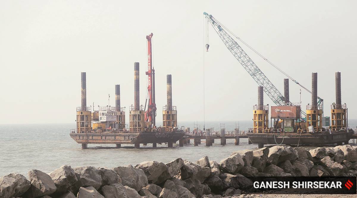
The Coastal Road as proposed by the BMC
The Municipal Corporation of Greater Mumbai (MCGM) had planned the Mumbai Coastal Road on the western side of the state capital to provide an alternate North-South Trunk route to improve mobility along with development of recreational open public spaces and greenery.
The proposed coastal road has a length of 29.20 km along the western coastal stretch of Mumbai. The project is to be constructed in two parts; the first part is the 10.58-km-long South Section, which would connect Princess Flyover Road to the Worli Sea link for which work is presently on. The second phase involves connecting Bandra Sea Link to Kandivali Junction. Work on this stretch is yet to commence.
The first phase of the project to be built at a cost of Rs 12,700 crore also entailed reclamation of land from the Sea. As per the plan, around 111 hectares of land was to be reclaimed. A part of this would be used for construction of the road while the remaining reclaimed space is to be used for constructing parks, cycle lanes, jogging tracks, promenades, and open green spaces.
As per the present proposal of the BMC based on which construction is taking place, the coastal road will contain a 20-metre wide promenade abutting the coast that will consist of a sidewalk, a cycling track and green zone. This will be followed by a 17-metre wide four-lane carriageway, an 11-metre wide median followed by another 17-metre wide four-lane road. Abutting this road stretch will be a sprawling open space of around 135 metres in width. This width of the open space will vary in size along the entire length of the coastal road.
According to the BMC, the coastal road will transform the way Mumbai commutes, adding the proposed green space will provide much-needed recreational spaces to the city. It also claimed that these seaside facilities would be within easy reach of the common public as opposed to such spaces being private backyards of a few or spots housing unsightly encroachments.
“Mumbai has been able to add only 320 Ha of public amenity spaces, including green spaces over the last two decades. It has not been possible to expand the open space area in the city due to sheer non-availability of land, since the city has limited land area, high density of population and nowhere to expand,” according to a report commissioned by the BMC on the coastal road.
The report highlights the “extremely poor access to open spaces in Mumbai, stating that open space ratio per 1,000 persons in Mumbai is only 0.03 hectares as against the planning norm of 6.2 Ha per 1,000 persons.
The report states that the massive reclamation that is being carried out for the coastal road project will generate 70 hectares of green space along the seaside for perpetuity. This open space can be developed for the public by creating cycling tracks, promenades, landscape and theme parks.
While BMC is betting big on the coastal road as a project that will not only improve city commute but also make areas around its vicinity more livable for Mumbai’s public, many architects and urban planners are questioning whether the project will actually revitalise the visual and economic aura of Mumbai’s western coastline.
Changes that Architects and Urban Planners are seeking
On March 2, 70 architects, urban designers, planners and professors wrote a letter to BMC commissioner IS Chahal, CM Uddhav Thackeray and state environment minister Aaditya Thackeray expressing their views on the need to undertake a “slight realignment” of the Coastal Road which, they said, would greatly improve the revenue and tourist potential of Mumbai’s waterfront.
The letter was written as many of these architects feared that the existing alignment of the coastal road would break Mumbaikars’ connect with the seafront, restricting not only access but also acting as visual barrier in way of people looking out towards the sea.
The proposal that was presented involved shifting the proposed open spaces towards the seaside.
“Considering the level of reclamation, while keeping the road in its entirety – we think it wise to move as many of the open spaces to the seaside as possible– this would enable a world-class waterfront open to all citizens retaining the much necessary vista on to the open uncluttered horizon….” the letter states.
The architects also raised the point that ideally, for a project of this scale, provisions should also be made to ensure that continuous open space should be made available for the public so that people can walk or cycle from one end of the coastal road to the other through a connected waterfront.
Under the existing alignment, there is a 400-metre and a 100-metre span of the promenade which is disconnected.
“The addition of continuous bicycle paths along the length of the reclamation, would allow one to cycle along the entire length of the city, thereby reducing the load on the road, as well as public transport on the north-south corridors on the west side,” the letter states.
Architect Alan Abraham, one of the driving forces behind the letter, said that the reason for sending out the letter was to ensure that the city’s residents have a universally accessible seafront with unhindered access.
“The proposal that we have submitted is feasible albeit at a slight cost due to design changes. These changes, however, are worth it in the long run for the city as this infrastructure that is being created is here to stay. Making these changes will ensure that citizens get more open space to use,” Abraham said.
Some of the architects who are proposing the changes have said that making these alterations and pushing the open spaces towards the sea would ensure that these spaces are preserved for perpetuity and are not opened up in the future for commercial development.
“The reclaimed open space is a veritable real estate gold mine. While the BMC has assured that no commercial development will be allowed on this open space, the fact that our leaders are known to tweak rules pertaining to real estate is well known. By shifting the open space towards the sea, these open public spaces will be better protected from future proposals for built-up development,” another architect who is a signatory to the letter said.
The architects have also raised questions on the rationale of having an 11-metre wide median that the BMC has proposed to divide the two carriageways. An 11-metre wide median is equivalent to a three-lane road and architects have claimed that reducing this median could further allow the BMC to increase the total open space area. The median on regular city roads and expressways is between one and two metres.
Pranav Naik, another architect and signatory to the letter, said that open spaces closer to the sea can allow them to be designed as a “coastal resilience zone” where the force of the tides can be buffered.
“Having the open spaces closer to the sea can allow them to be designed as ‘coastal resilience zones’ where the force of the tides can be buffered, as well as holding ponds for the flooding that occurs regularly,” said Naik.
He also pointed out that bus lanes made on a “highway-type road” with no connection to residential spaces are useless. “Overall, there is no clarity about what is being built. While we are suggesting changes, we are also asking for clarifications. We can help, as citizens, and architects. We have the brightest architects in the country signing this letter,” he added.
BMC’s take
The BMC, meanwhile, has said that the ship has already sailed with regard to any realignment of the project. It has claimed that more than 50 per cent of the project’s physical progress is already achieved as per the present alignment and hence any changes at this point of time are not possible.
“The suggestions of the Group of Architects, Urban Designers cannot be considered at this stage of the project due to following reasons. The present alignment has been planned in such a way that it fulfills the geometric requirements of alignment as per IRC Code ensuring suitability for urban high-speed Arterial road with 80-100Kmph speed and technical feasibility of interchanges to connect the coastal road with the existing road network,” Ashwini Bhide, Additional Municipal Commissioner (Eastern Suburb) and in-charge of Coastal Road department, said.
Architects, meanwhile, have stated that while the suggested changes could end up costing the BMC some more money, the changes could be worth the effort.

- The Indian Express website has been rated GREEN for its credibility and trustworthiness by Newsguard, a global service that rates news sources for their journalistic standards.
