- News
- City News
- dehradun News
- Climate change is fueling flash flood fury in Uttarakhand, say climatologists
Climate change is fueling flash flood fury in Uttarakhand, say climatologists
Climate change is fueling flash flood fury in Uttarakhand, say climatologists

So far in October, Uttarakhand has recorded 192.6 mm of rainfall against an average of 31.2 mm
Climate change is fueling flash flood fury in Uttarakhand, said climatologists. The state seldom witnesses any major spell of rain and thundershowers around this time. However, Uttarakhand saw incessant rainfall beginning Sunday night and went on till Tuesday.
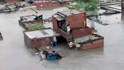
So far in October, Uttarakhand has recorded 192.6 mm of rainfall against an average of 31.2 mm. Out of this, 122.4 mm of mm was recorded in 24 hours itself. Around 64 people lost their lives on account of heavy rainfall and series of landslides.
The onus of these untimely showers over the state, experts said, can be attributed to the extended stay of the Southwest Monsoon 2021 over the country. The presence of monsoon current over the region means the presence of abundance of moisture over the landmass, keeping weather conditions favourable for the formation of the weather systems.
The low pressure area travelled all along the Northern Limit of Monsoon (NLM) which was then passing through parts of Central India. The system later moved north towards Uttarakhand and then recurved towards Uttar Pradesh. Also, post the retreat of Monsoon, dry northwesterly winds start blowing over North India. But the presence of multiple weather systems led to change in wind pattern and we could see strong humid easterly winds all along the Indo-Gangetic plains with depth of more than 8000 ft.
Professor Y P Sundriyal, Head of Department, Geology, HNB Garhwal University said, “Higher Himalayas, both climatically and tectonically, are highly sensitive, so much so, that at first stance construction of mega hydro-projects should be avoided. Or else they should be of small capacity. Secondly, construction of roads should be done with all scientific techniques. At present, we just see roads are being made or widened without taking proper measures such as no slope stability, lack of good quality retaining wall and rock bolting. All these measures can restrict the damage done by landslides up to some extent.”
District/Actual rain October 1-20 (mm)/Normal rains October 1-20 (mm)/Departure from normal
Almora/ 261.4/ 21.1/ 1139%
Bageshwar/ 262.1/ 21.1/ 1142%
Chamoli/ 187.0/ 20.9/ 795%
Champawat/ 452.1/ 57.0/ 693%
Dehradun/ 58.4 /32.0/ 82%
Haridwar/ 49.8 /17.1/ 191%
Nainital/ 406.2/ 41.4/ 881%
Pauri Garhwal/ 127.8/ 22.9/ 458%
Pithoragarh/ 228.4/ 47.1/ 385%
Rudraprayag/ 126.2/ 23.7/ 433%
Tehri Garhwal/ 95.5/ 23.2/ 312%
Udham Singh Nagar/53.6/ 36.5/ 869%
Uttarkashi/ 81.7/ 35.2/ 132%
(Data Courtesy: IMD)
So far in October, Uttarakhand has recorded 192.6 mm of rainfall against an average of 31.2 mm. Out of this, 122.4 mm of mm was recorded in 24 hours itself. Around 64 people lost their lives on account of heavy rainfall and series of landslides.
The onus of these untimely showers over the state, experts said, can be attributed to the extended stay of the Southwest Monsoon 2021 over the country. The presence of monsoon current over the region means the presence of abundance of moisture over the landmass, keeping weather conditions favourable for the formation of the weather systems.
The low pressure area travelled all along the Northern Limit of Monsoon (NLM) which was then passing through parts of Central India. The system later moved north towards Uttarakhand and then recurved towards Uttar Pradesh. Also, post the retreat of Monsoon, dry northwesterly winds start blowing over North India. But the presence of multiple weather systems led to change in wind pattern and we could see strong humid easterly winds all along the Indo-Gangetic plains with depth of more than 8000 ft.
According to G P Sharma, President- Meteorology and Climate Change, Skymet Weather said, “It is very much evident that had the Monsoon departed timely, we would not have seen such torrential rains. Weather conditions were very favourable for such heavy precipitation on account of multiple weather systems coming together. While there was a western disturbance up in the hills, two low pressure areas were seen over Madhya Pradesh and the Bay of Bengal, respectively. However, what prompted these systems was the delayed withdrawal of Monsoon. Usually, weather systems do not travel inland, especially over the places from where Monsoon has retreated. And since by this time the NLM was still passing through Madhya Pradesh, these low pressure areas tended to travel deep inside the land.”
Professor Y P Sundriyal, Head of Department, Geology, HNB Garhwal University said, “Higher Himalayas, both climatically and tectonically, are highly sensitive, so much so, that at first stance construction of mega hydro-projects should be avoided. Or else they should be of small capacity. Secondly, construction of roads should be done with all scientific techniques. At present, we just see roads are being made or widened without taking proper measures such as no slope stability, lack of good quality retaining wall and rock bolting. All these measures can restrict the damage done by landslides up to some extent.”
District/Actual rain October 1-20 (mm)/Normal rains October 1-20 (mm)/Departure from normal
Almora/ 261.4/ 21.1/ 1139%
Bageshwar/ 262.1/ 21.1/ 1142%
Chamoli/ 187.0/ 20.9/ 795%
Champawat/ 452.1/ 57.0/ 693%
Dehradun/ 58.4 /32.0/ 82%
Haridwar/ 49.8 /17.1/ 191%
Nainital/ 406.2/ 41.4/ 881%
Pauri Garhwal/ 127.8/ 22.9/ 458%
Pithoragarh/ 228.4/ 47.1/ 385%
Rudraprayag/ 126.2/ 23.7/ 433%
Tehri Garhwal/ 95.5/ 23.2/ 312%
Udham Singh Nagar/53.6/ 36.5/ 869%
Uttarkashi/ 81.7/ 35.2/ 132%
(Data Courtesy: IMD)
FacebookTwitterLinkedinEMail
Start a Conversation
end of article
Quick Links
Delhi Air PollutionDelhi TemperatureChennai WeatherBangalore TemperatureCovid vaccination centres in DelhiCoronavirus in DelhiRTPCR test in GurgaonHyderabad RainPollution level in BangaloreDelhi SmogDelhi TemperatureNoida AQIGurgaon AQI todayFire in MumbaiMumbai RainsCovid 19 RT PCR Test in NoidaDelhi AQI todaySrinagar encounter

