
- News
- City News
- noida News
- Master plan for 10 years: 42% of Ghaziabad land to be for houses
Master plan for 10 years: 42% of Ghaziabad land to be for houses
ARTICLES

Master plan for 10 years: 42% of Ghaziabad land to be for houses Driver pulled out after car falls into ditch in police commissionerate WHO estimates globally more than 10 Cr people get infected with Hepatitis A every year: Everything you should know about Hepatitis A disease, prevention and vaccination Testing to be intensified in societies, rural areas

Picture for representational purpose only.
GHAZIABAD: The master plan for the next 10 years in the district will see a lot of changes in terms of land use in keeping with the growing population. Officials said the new plan was likely to take effect from January next year.
While the base map for the master plan for Loni and Muradnagar-Modinagar is ready, the one for Ghaziabad is likely to be completed by November.
When all the maps are ready, they will be examined by the consultancy evaluation and review committee (CERC) and sent to the state government for approval. Once approved, the GDA board will go through the plan the final time and start implementing it from January next year, officials said.
“The master plan 2031 is ready for Loni and Modinagar-Muradnagar. The one for Ghaziabad is likely to be ready by November,” said Asheesh Shivpuri, the chief architect and town planner, GDA.
“In the next 10 years, the population is expected to grow by 10 lakh, which means more land will be required for residential purposes. Accordingly, change in land use pattern from agricultural to residential will be effected in the new master plan,” he added.
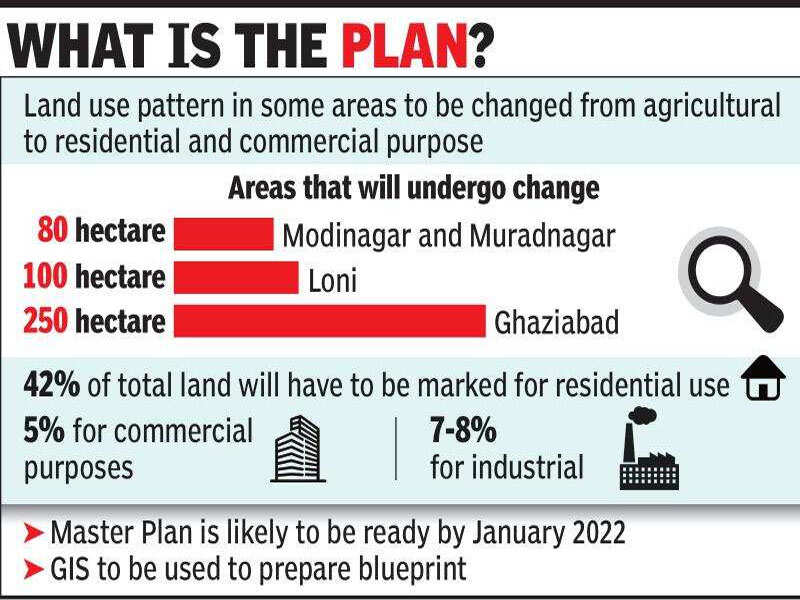
In Loni, the land use pattern of about 100 hectares would be changed from agricultural to residential. “Likewise for Modinagar-Muradnagar, 80 hectares will be changed from agricultural to residential. For Ghaziabad, 250 hectares have been earmarked for change in land use pattern,”said Shivpuri.
Officials said that 42% of the total land would be marked for residential use while 5% would be set aside for commercial projects and 7-8% for industry.
Until now, master plans would be made for 20 years, but this time, the tenure has been halved to 10. A Centre empanelled consultant, DDF, has been entrusted with the responsibility of preparing the plan.
“For the first time, we have involved geographical information system for satellite imagery. Unlike previous plans, where everything was done manually, things will be more accurate and precise this time,” he added. The agency has used satellite images procured from Hyderabad’s National Remote Sensing Centre.
While the base map for the master plan for Loni and Muradnagar-Modinagar is ready, the one for Ghaziabad is likely to be completed by November.
When all the maps are ready, they will be examined by the consultancy evaluation and review committee (CERC) and sent to the state government for approval. Once approved, the GDA board will go through the plan the final time and start implementing it from January next year, officials said.
“The master plan 2031 is ready for Loni and Modinagar-Muradnagar. The one for Ghaziabad is likely to be ready by November,” said Asheesh Shivpuri, the chief architect and town planner, GDA.
“In the next 10 years, the population is expected to grow by 10 lakh, which means more land will be required for residential purposes. Accordingly, change in land use pattern from agricultural to residential will be effected in the new master plan,” he added.
In Loni, the land use pattern of about 100 hectares would be changed from agricultural to residential. “Likewise for Modinagar-Muradnagar, 80 hectares will be changed from agricultural to residential. For Ghaziabad, 250 hectares have been earmarked for change in land use pattern,”said Shivpuri.
Officials said that 42% of the total land would be marked for residential use while 5% would be set aside for commercial projects and 7-8% for industry.
Until now, master plans would be made for 20 years, but this time, the tenure has been halved to 10. A Centre empanelled consultant, DDF, has been entrusted with the responsibility of preparing the plan.
“For the first time, we have involved geographical information system for satellite imagery. Unlike previous plans, where everything was done manually, things will be more accurate and precise this time,” he added. The agency has used satellite images procured from Hyderabad’s National Remote Sensing Centre.
FacebookTwitterLinkedinEMail
Start a Conversation
end of article
Quick Links
Delhi Air PollutionDelhi TemperatureChennai WeatherBangalore TemperatureCovid vaccination centres in DelhiCoronavirus in DelhiRTPCR test in GurgaonHyderabad RainPollution level in BangaloreDelhi SmogDelhi TemperatureNoida AQIGurgaon AQI todayFire in MumbaiMumbai RainsCovid 19 RT PCR Test in NoidaDelhi AQI todaySrinagar encounter
Popular Categories
Hot on the Web
Top Trends
Olympics 2021Covid cases in IndiaBajrang PuniaCoronavirus India update liveOBC Bill 2021Lionel MessiParliament SessionNeeraj ChopraDevyani International IPORahul GandhiMumbai School Reopen NewsMarburg VirusWeekly HoroscopePrayagraj FloodAfghanistan India NewsTropical Storm FredHoroscope todayLatest News
Trending Topics
Living and entertainment
Copyright © 2021 Bennett, Coleman & Co. Ltd. All rights reserved. For reprint rights: Times Syndication Service