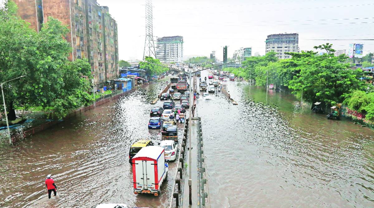
 Intense waterlogging on Santacruz–Chembur Link Road Sunday. (Express photo by Amit Chakravarty)
 Mumbai recorded 235 mm rainfall in 24 hours until 8.30 am Sunday. Of this, 200 mm was recorded just six hours between 11.30 pm Saturday and 5.30 am Sunday, making it was the second extreme weather event to hit Mumbai in two days. The city recorded 253 mm rainfall on Friday.
With this, the city has surpassed the average July rainfall in the first 18 days. The city has recorded 849.7 mm rain, while the average July rainfall is 827.5 mm.
Till 11.30 pm on Saturday, the IMD’s Santacruz observatory had recorded only 16 mm of rain for the day, but it shot up to 233 mm by 5.30 am.
According to the district forecast, Mumbai is under an orange alert with a forecast of heavy to very heavy rainfall for the next five days. As per the regional forecast, rain in the north Konkan, which includes Mumbai, will be widespread till Thursday. A widespread rainfall means 76 -100 per cent of stations in the region receive rainfall.
While early Friday’s extreme rainfall, totalling 253 mm, was confined to the western suburbs, the Saturday-Sunday downpour was widespread — from the island city to the northern suburbs of Mumbai.
The development of “in situ convective clouds” led to the development of such extreme weather situations for Mumbai, according to IMD officials, who said forecasting such events days in advance was impossible as weather models do not pick up these localised events.
The IMD had issued a nowcast warning at 1-1.30 am and 3.30 am Sunday.
Dr Jayanta Sarkar, scientist and head of IMD Mumbai, said, “We did issue nowcast warnings and also an impact-based forecast was issued at 1 am Sunday.”
The IMD’s impact-based forecast asked those staying at vulnerable places to be moved to safety. BMC officials, however, said by the time the forecast was issued it was too late.
In a 24-hour period, ending at 8.30 am Sunday, the IMD’s Santacruz observatory had recorded 235 mm of rain and the Colaba observatory 197 mm of rain. The rain recorded by the Santacruz observatory is the second-highest for the season, the highest, so far, being that recorded on July 16 (253 mm). In June too, a triple-digit rain figure in a 24-hour span was recorded at 231.3 mm between June 9 and 10.
Weather experts pointed out that as per the images from the weather department’s doppler radar, the cloud top height was nearly 18 km, or 60,000 feet, an unusual feature. “This type of thunderstorm is definitely very unusual. For a coastal station like Mumbai, thunderstorm formations are quite a few, even in the pre-monsoon period (May-June), let alone in July. Even with very severe thunderstorms, cloud height reaches up to 16-17 km, this was very high and requires high instability. We are also confused about how such instability was constructed for cloud height to reach 18 km,” Sunil Pawar, senior scientist, IITM- Pune, said.
Pawar added, “Thunderstorm development is very fast, complex and localised. Therefore, predicting it by weather model is difficult.”
The storm, which was described by expert meteorologists and forecasters as “massive” and “monstrous”, formed initially over Raigad district late Saturday, then slowly moved north along the west coast till it reached south Gujarat.
“The absence of upper-level winds further exacerbated the intensity because of the sheer height of the cloud structure which had formed over Mumbai. Images from the IMD’s doppler radar showed that the thunderstorm had a cloud top height of nearly 18 km or 60,000 feet. In other words, the vertical extent of this monster thunderstorm is approximately twice that of Mount Everest,” tweeted Akshay Deoras, an independent meteorologist and PhD researcher at the department of meteorology, University of Reading.

- The Indian Express website has been rated GREEN for its credibility and trustworthiness by Newsguard, a global service that rates news sources for their journalistic standards.
