
Top Searches
- News
- City News
- bengaluru News
- Weather forecast live updates: Incessant rainfall causes flood-like situation in parts of Bihar
Weather forecast live updates: Incessant rainfall causes flood-like situation in parts of Bihar
A short but intense spell of pre-monsoon rain was recorded in several parts of Delhi on Wednesday. It brought down the maximum temperature to 34.2 degrees Celsius, which was five degrees below normal. While the monsoon is still a few days away, India Meteorological Department forecasts the possibility of very light rain today as well. Widespread rainfall was witnessed across Bihar in the last 24 hours and the India Meteorological Department (IMD) issued orange code alert for downpour today and yellow code alert for Thursday and Friday. Stay with TOI for all the latest updates:Read Less
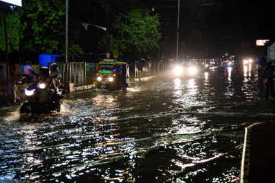
Incessant rainfall causes flood-like situation in some areas of East Champaran district in Bihar. Visuals from Lauriya and Narkatiaganj. (ANI)

An IMD official said, "There is a cyclonic circulation in the Arabian sea that came very close to North Konkan region pulling in moisture, thus bringing in heavy rains for parts of Mumbai's eastern suburbs, Thane and Palghar. We have therefore upgraded the weather warnings accordingly."
Several parts of Mumbai recorded heavy rain activity on Thursday evening coupled with low visibility. The IMD Santacruz observatory in the nine hours ending at 5.30pm has recorded 58.2 mm of rains.
Maharashtra's Raigad district records 66 mm rainfall in 24 hours
Maharashtra's Raigad experienced heavy to moderate showers in different parts in the last 24 hours and the coastal district has already received 17.23 per cent of its yearly rainfall quota, the local administration said on Thursday.
Maharashtra | Heavy rainfall likely to occur at isolated places in the district of Mumbai, Thane, Palghar & Raigad on June 18 and 19: India Meteorological Department (IMD) (ANI)
Excessive rain in Nepal during last 48-50 hours and in Bihar has added 4.25-4.5 lakh cusec water to Gandak river, which is 9 times more compared to normal days. District administrations and department engineers are keeping a close watch: Bihar Minister Sanjay Jha (ANI)
Several low-lying areas and thoroughfares in the city and its outskirts lay inundated on Thursday as heavy rain continued to lash parts of Bengal, with the Met department predicting more downpour over the next three days under the influence of a vigorous southwest monsoon and a cyclonic circulation. Incessant showers in south Bengal have increased water levels in many rivers, including Ajoy, Darakeswar, Brahmani, Shilabati, Subarnarekha and Kangsabati, raising fears of a flood-like situation in the adjoining areas.
Heavy rains in Mumbai
#WATCH| Water logged in #Andheri due to heavy rains in #Mumbai https://t.co/dsT0XpDp5C
— TOI Mumbai (@TOIMumbai) 1623931336000UP receives light rains, thundershowers; similar forecast for tomorrow
Light to moderate rains along with thundershowers lashed few places in eastern Uttar Pradesh and at isolated places over western parts of the state in the last 24 hours, the Met office said here on Thursday. Some parts of eastern UP recorded heavy rains, the officials said. Rainfall was reported from Trimohanighat (Maharajganj), Dudhi (Sonbhadra), Dhaurahara (Kheri), Ghazipur, Salempur (Deoria), Mohammedabad (Ghazipur), Hata (Kushinagar), Chandauli, Turtipar (Ballia) and Rajghat (Varanasi), they said.
Maharashtra: Waterlogging in Thane due to heavy rain
#WATCH| Waterlogging due to rain showers in #Thane Vandana area on Thursday https://t.co/RqHjvD9Yae
— TOI Mumbai (@TOIMumbai) 1623925930000Conditions are not favourable for further advance of the monsoon into Rajasthan, some parts of Punjab, Haryana and Delhi, the India Meteorological Department said on Thursday. However, there could be slow progress into some more parts of Gujarat and Uttar Pradesh during the next two to three days, it said. The Northern Limit of Monsoon (NLM) continues to pass through Diu, Surat, Nandurbar, Bhopal, Nowgong, Hamirpur, Barabanki, Bareilly, Saharanpur, Ambala and Amritsar. (PTI)
Rain lashes parts of Thane
Durgapur Barrage releases 12,000 cusec water
Authorities of Durgapur Barrage in West Bengal released 12,000 cusec of water till Thursday morning after two dams of Damodar Valley Corporation discharged water due to incessant rain in Jharkhand. (PTI)
Weather warning and rainfall forecast for next 5 days
Moderate/severe thunderstorms with frequent cloud to ground lightning very likely over Uttarakhand, Uttar Pradesh, east Madhya Pradesh, Chhattisgarh, Bihar and Jharkhand during June 17 and 18. This may cause injuries leading to casualties to people and animals staying outdoors: IMD
An offshore trough runs from south Karnataka to north Kerala coast. Under its influence, widespread rainfall with isolated heavy to very heavy falls very likely over Konkan & Goa and Madhya Maharashtra during next 2-3 days; over Karnataka and Kerala & Mahe during next 2 days.
IMD
A cyclonic circulation lies over east Uttar Pradesh & neighbourhood. Under its influence, fairly widespread rainfall with isolated heavy to very heavy falls very likely over east Uttar Pradesh during next 2-3 days: IMD
Due to presence of cyclonic circulation over Gangetic West Bengal and adjoining area and strong moisture incursion from Bay of Bengal, widespread rain/thunderstorm accompanied with lightning and heavy to very heavy rainfall is likely to continue over the districts of West Bengal during June 17-19: IMD
A cyclonic circulation lies over Gangetic West Bengal & neighbourhood. Under its influence, widespread rainfall with isolated heavy to very heavy falls very likely over Bihar, Jharkhand, West Bengal & Sikkim and north Odisha during next 2-3 days.
IMD
Large-scale atmospheric conditions are not favourable for further advance of monsoon into Rajasthan, remaining parts Punjab, Haryana and Delhi. However, there could be slow progress into some more parts of Gujarat state and Uttar Pradesh during next 2 to 3 days: IMD