
Top Searches
- News
- City News
- delhi News
- Delhi rainfall already 7 times more than May normal
Delhi rainfall already 7 times more than May normal

File photo of rain in Delhi
NEW DELHI: Delhi has already received nearly seven times more rainfall this month than what is considered normal for the month.
Track the pollution level in your city
While the normal is 19.7mm, this May’s figure stands at 144.8mm, aided by western disturbances and a strong spell as an aftermath of cyclone Tauktae.
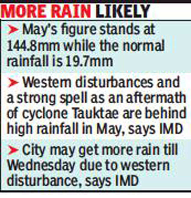
On Sunday, Delhi’s weather again saw a sharp change, with gusty wind and overcast skies taking over from what seemed like another hot day. IMD says the influence of another western disturbance may bring more rain and gusty winds till Wednesday.
Expect light rain over next 2-3 days
Kuldeep Srivastava, scientist at IMD and head of Regional Weather Forecasting Centre in Delhi, said parts of south Delhi and some isolated locations received very light rain, with gusty winds blowing in most parts of the capital.
“We can expect similar weather over the next two to three days, with wind speed ranging at 30-40km/hr. It may be even higher on Tuesday,” said Srivastava.
A significant spell of rain in the next 24 hours may see the capital break its all-time record for May — 165mm — established in 2008. “May generally does not see much rain, with light pre-monsoon activity recorded during the month. This year, the trend will continue into June,” said Srivastava.
Delhi’s air quality index (AQI) was in the “moderate” category on Sunday at101. SAFAR, a central forecasting body, predicts AQI to stay in this category, with PM10 as the lead pollutant, for Monday. It is expected to be in the “moderate” to “satisfactory” range on June 1 and 2.
Track the pollution level in your city
While the normal is 19.7mm, this May’s figure stands at 144.8mm, aided by western disturbances and a strong spell as an aftermath of cyclone Tauktae.
On Sunday, Delhi’s weather again saw a sharp change, with gusty wind and overcast skies taking over from what seemed like another hot day. IMD says the influence of another western disturbance may bring more rain and gusty winds till Wednesday.
Expect light rain over next 2-3 days
Kuldeep Srivastava, scientist at IMD and head of Regional Weather Forecasting Centre in Delhi, said parts of south Delhi and some isolated locations received very light rain, with gusty winds blowing in most parts of the capital.
“We can expect similar weather over the next two to three days, with wind speed ranging at 30-40km/hr. It may be even higher on Tuesday,” said Srivastava.
A significant spell of rain in the next 24 hours may see the capital break its all-time record for May — 165mm — established in 2008. “May generally does not see much rain, with light pre-monsoon activity recorded during the month. This year, the trend will continue into June,” said Srivastava.
Delhi’s air quality index (AQI) was in the “moderate” category on Sunday at101. SAFAR, a central forecasting body, predicts AQI to stay in this category, with PM10 as the lead pollutant, for Monday. It is expected to be in the “moderate” to “satisfactory” range on June 1 and 2.
FacebookTwitterLinkedinEMail
Start a Conversation
end of article
Popular Categories
Hot on the Web
Top Trends
Mann ki Baat highlightsCorona cases in IndiaIPL 2021 newsCBSE Board exam 2021Coronavirus India update liveTamil Nadu lockdownDelhi lockdown newsKarnataka lockdown newsMaharashtra lockdown newsUAE travel banTelangana lockdownTamil Nadu lockdown newsPfizer covid vaccineBlack FungusCovid vaccine registrationCowin AppHoroscope todayLatest News
Trending Topics
Living and entertainment
Copyright © 2021 Bennett, Coleman & Co. Ltd. All rights reserved. For reprint rights: Times Syndication Service