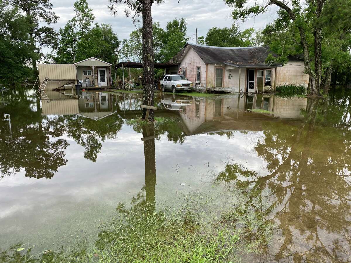
Fannett is seeing quite a bit of flooding just one day into the week-long storm.
Kim Brent/The Enterprise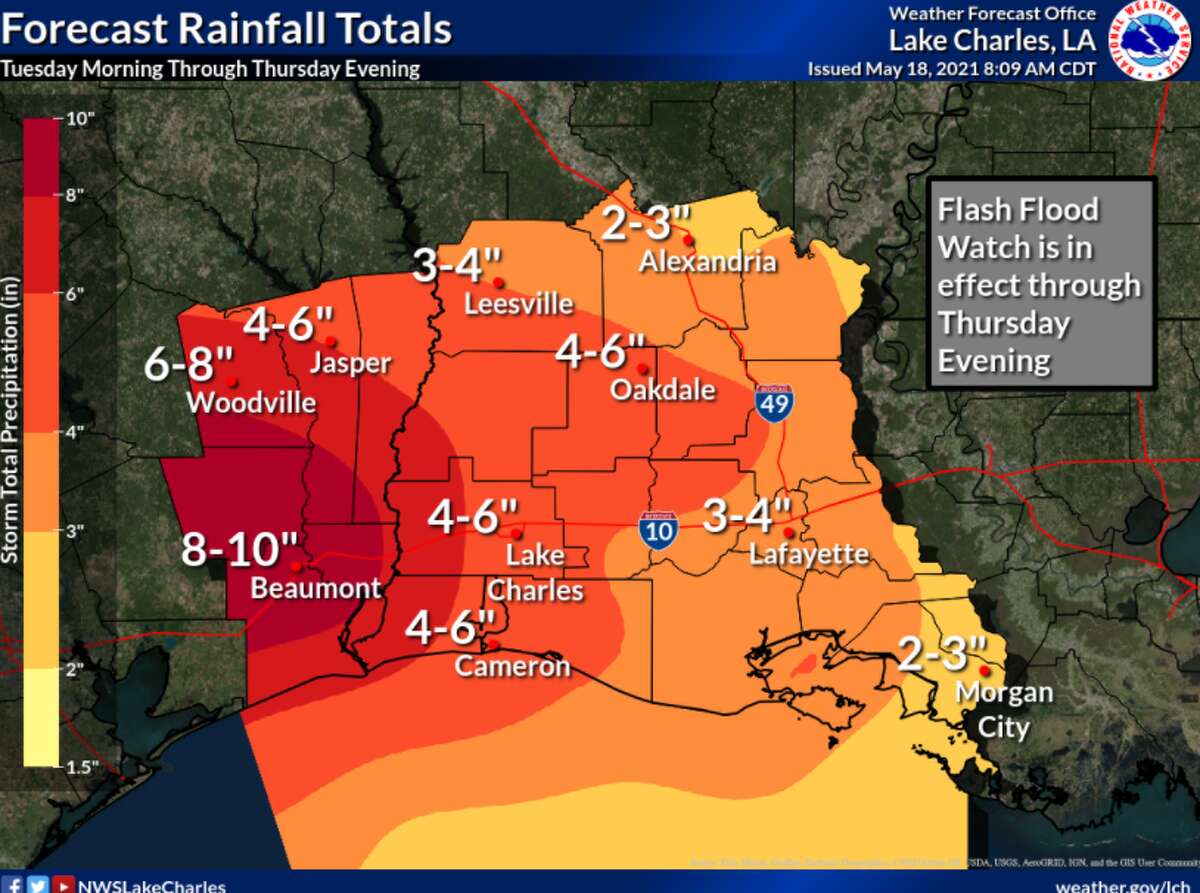

Update 3:10 p.m.:
Orange County officials are recommending a voluntary evacuation for the Lake View area, including Four Oaks, Ranch Road, Loving Acres, Connelly Road and other low lying areas along the Neches River in Orange County.
The county also has set up sand bagging stations for residents here:
- Precinct 1 Maintenance barn located on North Hwy 87 at North Teal
- 11897 State Hwy 62 in Mauriceville directly across from Market Basket on Hwy 62
- Precinct 3 County Maintenance barn located on 2502 West Roundbunch Road
- Precinct 4 County Maintenance barn located on 375 Claiborne Street
Update 3:05 p.m.:
Newton County Judge Ken Weeks has issued a disaster declaration and voluntary evacuation.
The disaster declaration was implemented due to the "imminent threat of widespread or severe damage, injury or loss of life or property resulting from countywide conditions created by torrential rainfall over an excessive period of time, affecting Newton County by causing river flooding in populated areas as well as major infrastructure damage preventing access to or the safe passage on many roadways," the declaration read.
Such a move also allows the county official to call for an evacuation, which he did at the same time.
The evacuation, which is voluntary, is based on the forecasted rainfall and likely emergency release of water from the Toledo Bend Dam by the Sabine River Authority, "which is expected to result in flooding that has the great potential of causing severe bodily injury or the loss of human life in the low-lying areas of the Sabine River corridor in Newton County," the order said.
Update 2:30 p.m.:
Nearly all the National Weather Service survey points at rivers, creeks and bayous around Southeast Texas were running high as of Tuesday afternoon.
Here's where they sat:
- The Neches River at Saltwater Barrier was at just over 6 feet, or moderate flood stage. At that level, according to the National Weather Service, water is about 2 feet over portions of Four Oaks Ranch Road. The NWS graph does not yet show a crest for the river but it's expected to hit nearly 11 feet by Sunday afternoon. At that level, area residents are expected to see major flooding along the river including in Northwest Orange County from Lake View to Saltwater Barrier with several homes and camps flooded. Flooding also would occur along the river in Beaumont.
- The gauge on the Neches River at Beaumont was not giving a reading on Tuesday afternoon, but it was predicted to already be above minor flood stage, which occurs at 4 feet. The NWS also doesn't give an expected crest for this section, but it also is expected to reach nearly 11 feet by Sunday afternoon. At that time, major flooding is expected at Colliers Ferry Park and around the Beaumont Country club. Residential roads off Pine Street also could be impassable, and some water could reach homes in that area and Northeast Beaumont.
- Pine Island Bayou near Sour Lake was just over 16 feet as of Tuesday afternoon, which puts the bayou above minor flood stage. The bayou is expected to reach nearly 28.5 feet around Friday afternoon, and hover at that level through Sunday morning. At that level, moderate lowland flooding is possible, and water could cover roads in Bevil Oaks.
- The Sabine River at Orange was the least swollen body of water as of Tuesday afternoon. The river was not at flood stage and was expected to only barely reach action levels of 3.5 feet through the weekend.
- The Sabine River at Deweyville was well into the moderate flood level as of Tuesday afternoon. The NWS does not show an expected crest for the river yet, but it's not shown to be expected to rise above 27 feet through the weekend. At that level, the weather service expects widespread moderate lowland flooding. Some homes closest to the river could see flooding.
- The Neches River at Evadale was sitting at nearly 19 feet -- still well within the "minor" flood range -- as of Tuesday afternoon. However, starting Wednesday afternoon, the river was expected to make a significant jump to nearly 21 feet, which would put it in the moderate flood risk category. At that level, the NWS expects to see moderate lowland flooding and water across some roads near the river.
- Village Creek near Kountze appeared to be running just over 18 feet -- slightly above NWS predictions -- on Tuesday afternoon. The creek currently is forecast to peak just under 20 feet on Saturday afternoon. At that level, water could begin to flow over the bridge on Farm Road 418 as well as several other locations. Roads in Village Creek State Park also could begin to see water.
- The Neches River at Town Bluff was well into moderate flood stage on Tuesday afternoon, but it'd already started to come down. The river was running at nearly 77 feet, which could cause flooding in the Mont Neches, Barlow Lake and Sheffields Ferry communities.
- After a significant dip on Monday afternoon, the Sabine River near Bon Wier was back up to moderate flood stage on Tuesday afternoon. The river is expected to crest at 35.5 feet on Thursday evening, according to the NWS. At that point, secondary roads in the Merryville and Bon Wier areas would be closed.
However, these predicted levels are subject to change based on weather conditions or water releases upstream.
As of Monday evening, the Toledo Bend Reservoir was operating with 11 gates open 1 foot each.
According to the U.S. Army Corps of Engineers on Tuesday, the Sam Rayburn Reservoir was just over 7 feet above normal elevation, but no water was being released. BA Steinhagen Lake -- Dam B -- was just above normal elevation, and releasing 44,800 cubic feet of water per second. The dam is located between Jasper and Woodville and intends to assist the Sam Rayburn Reservoir in providing flood control to Southeast Texas, among other goals.
Update 2:10 p.m.:
Southeast Texans across the region are prepping for another round of possible flooding. In Silsbee, Jack Favors is prepping bags for the Silsbee dance academy, which already had several inches of flooding from yesterday’s torrential downpour. / @BmtEnterprise pic.twitter.com/psCozbobJJ
— Isaac Windes (@isaacdwindes) May 18, 2021
Update 1:30 p.m.:
Port Arthur ISD will pivot to virtual learning on Wednesday due to impending inclement weather and potential for severe flash flooding.
"Southeast Texas experienced a torrential downpour yesterday that had many streets in our area flooded. We have been closely monitoring the weather and due to the heavy rains expected early tomorrow morning and throughout the day that will make travel to and from our campuses unsafe, the district has made the decision to close all facilities on Wednesday, May 19th and pivot all students to virtual instruction," the district said in an update sent to students.
Update 12:55 p.m.:
Similar flooding if not worse here off 365. pic.twitter.com/oN2MoAyePy
— Jorge Ramos (@byjorgeramos) May 18, 2021
Update 12:50 p.m.:
From Hardin County Emergency Management:
We are closely monitoring weather conditions throughout the County and Region, and remain vigilant to support the needs of local jurisdictions responding to any needs of the public associated with this unsettled weather pattern over the next week.
If anyone needs sandbags, we will have bags and sand available at each of the following Hardin County Road & Bridge Departments and Fire Stations:
R&B 1 - 1290 Hwy 327 West, Silsbee (409) 385-5501
R&B 2 - 1315 North Pine Street, Kountze (409) 246-3972
R&B 3 - 13745 FM 787, Saratoga (936) 274-5411
R&B 4 - 100 Southland Drive, Lumberton (409) 755-4584
ESD 2 - (Lumberton Fire Station #2) 8890 Keith Road, Lumberton
ESD 5 - (Pinewood Fire Station) 333 Commercial Dr, Sour Lake
Update 12:15 p.m.:
As the potential for serious flooding looms, Hardin County Judge Wayne McDaniel is reminding residents who haven’t already to sign up for the Southeast Texas Alerting Network.
The system uses text messages, e-mail or phone messages to provide important information to residents during a disaster.
“If you are not already registered to receive these alerts, I recommend that you do so, or if you are only registered for voice alerts, I recommend that you also register for text/email alerts,” he said in a Facebook post.
Registration can be completed at www.thestan.com/register.
Update noon:
Jefferson County already is asking residents to self-report damages to homes and businesses.
“The objective of this survey is to identify damages and support emergency management officials across the state gain an understanding of damages that have occurred during the recent severe weather event,” according to a county news release. The survey can be found at damage.tdem.texas.gov.
The release was one of the first in what’s likely to be a slew of information coming from Southeast Texas officials over the next few days.
Jefferson County Judge Jeff Branick said he and other officials have a weather briefing at Tuesday afternoon, at which point he’ll decide whether to issue a disaster declaration in anticipation of Wednesday and Thursday’s heavy rain chances.
“If it stays the same (the decision) probably will be to make sure we have a disaster declaration in place …” he said.
Branick said he also is expecting the county’s emergency operations center to be activated by early Wednesday morning.
In preparation for the rain, the county has opened four sandbag locations. Residents are asked to bring a shovel.
Precinct 1: 20205 W. Hwy 90, China
Precinct 2: 7759 Viterbo Rd., Nederland and 12880 Farm Road 365, Labelle
Precinct 3: Hwy 124, Hamshire
Precinct 4: 7780 Boyt Rd., Cheek
Update 11:30 a.m.:
Jasper County residents now have two locations to get sandbags.
County Commissioner Vance Moss reports that sand and sandbags are available at the county barn on Farm Road 1004 in Buna. They also will be available at the Evadale Fire Station.
Residents are asked to bring their own scoop/shovel to the Evadale location.
Continued rain predictions show that a number of rivers and other bodies of water likely will enter major flood stage by the end of the week.
The Neches River at Saltwater Barrier is expected to reach at least 8.3 feet by Saturday afternoon, according to the National Weather Service’s Advanced Hydrologic Prediction Service. However, even that prediction doesn’t yet appear to be the river’s expected crest.
The Sabine River at Deweyville appears to be expected to crest in moderate flood stage — just under 27 feet — this afternoon.
However, these predictions can change based on weather patterns and water releases upstream.
With the rising waters, Hardin County Judge Wayne McDaniel has asked residents to use the next 24 hours to prepare for the possibility of flooding.
“The ground is saturated and some flooding is already occurring throughout the county,” he wrote in a Facebook post. “Additional heavy rainfall is expected overnight and tomorrow through Thursday. Add to that all the rainwaters that are draining this direction from the north, the ongoing high flow release from B.A. Steinhagen Lake Dam and the anticipated release from the Sam Rayburn Dam, there is a lot of water headed our way and the time to prepare is now.”
The city of Port Arthur also is asking residents to help with drainage by pulling their garbage cans away from the street.
Original story:
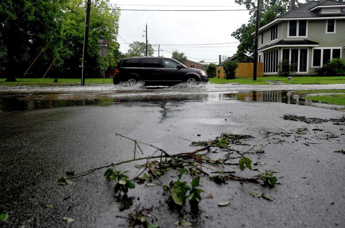
Forecasters are expecting widespread showers and thunderstorms to return on Tuesday, and a flash flood watch will remain in effect through much of the week.
The news comes just one day after parts of the region already clocked up to 17 inches of rainfall. As a result, the flash flood watch will continue through at least 7 p.m. Thursday, according to the National Weather Service Lake Charles office.
“We have another little upper-level disturbance, and this is another in a series of upper-level disturbances that (are) going to be moving over the area in the next few days,” NWS meteorologist Donald Jones said in a Tuesday morning briefing.
With that, the high rain chances likely will continue into Friday.
The Weather Prediction Center — one of nine service centers under the NWS which helps in medium-range precipitation forecasting — listed Southeast Texas’ risk for excessive rainfall at moderate, or a 25% to 50% chance of seeing flash flooding within 25 miles of any location in the region.
“It’s fairly unusual for us to get a risk that high — especially outside of a tropical system,” Jones said.
Over the course of the next two to three days, Beaumont is foretasted to see anywhere from 8 to 10 inches of additional rain. In Woodville forecasters expect to see 6 to 8 inches of rainfall over the next two or three days, and Jasper could see up to 6 inches during the same time period.
“It’s important to keep in mind while we are looking at this, that there are definitely going to be some locally-higher amounts,” Jones said. “Our rainfall forecasts does not account for those extremely high rainfall values. Nobody could’ve predicted 16 inches in one day in an individual location.”
Jones said a good rule of thumb to gauge potential local rainfall totals would be to double the rainfall totals forecast across an area.
Despite the threat of flash flooding, Southeast Texas will only have a marginal risk — 1 out of 5 — for severe weather.
To account for the potential risks, Tyler County Judge Jacques Blanchette has issued a disaster declaration.
Such a declaration would give the county judge powers such as ordering an evacuation or a curfew. However, he hasn’t yet made any such announcement.
jorge.ramos@beaumontenterprise.com
twitter.com/byjorgeramos