Explainer
The beasts to our east: What are El Ninos and La Ninas?
We hear the names but what do they mean for our weather? What does the Pacific have to do with our climate? And how will La Ninas and El Ninos change as the world warms up?
By Peter Hannam
As a giant island, Australia cops weather from all directions. One of the main drivers of our climate, particularly for those living in eastern parts of the country, periodically roars out of the Pacific.
Whether it’s an El Nino bringing severe droughts or a La Nina whipping up severe tropical cyclones and floods, farmers and firefighters and most everybody else have cause to keep a wary eye on subtle temperature changes in the waters to Australia’s north-east.
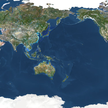
The equatorial Pacific is the place where these climate-driving beasts to our east are created. The Pacific accounts for about a third of the Earth’s surface area and so the complex interactions between the ocean and the atmosphere have a big sway over the global climate.
Both the El Nino and La Nina are ends of a weather spectrum but they are collectively known to scientists as the El Nino-Southern Oscillation (ENSO). And they play a key role in shaping Australia’s weather.
A La Nina phase, at the cooler end of the ENSO flux, is holding sway after a soggy conclusion to 2020 for eastern Australia.
And, as humans load up the atmosphere with ever more greenhouse gases, these interactions and their impacts are beginning to change in ways scientists are trying to grasp and to forecast for the future. More frequent and extreme El Ninos and La Ninas, however, seem unavoidable.
So, what are El Ninos and La Ninas and what are their impacts on the ground? What can we expect from this summer’s La Nina? And how will these natural fluctuations change in the long term?

A Peruvian fishing community carries its patron saint during a Catholic celebration. In the 1600s, fishermen in Peru coined the term El Nino (“little boy” or Christ child”) to describe a weather event that left them low on seafood around Christmas time. Credit:Getty Images
Where did the names Nino and Nina come from?
As with many natural phenomena, these gained a name before people understood what was really going on.
El Nino, or “little boy” or “Christ child” in Spanish, was how Peruvian fishermen in the 1600s came to describe the appearance of relatively warm currents off the South American Pacific coast, often around Christmas. Since migrating fish prefer the more nutrient-rich cooler waters, El Ninos were associated with poor catches.
In an early case of gender balance, the opposite phase was dubbed La Nina or “little girl”, making for fuller fishing nets.
In an early case of gender balance, the opposite phase was dubbed La Nina or "little girl", making for fuller fishing nets.
As global communications improved, scientists began to identify relationships across the big ocean basins. Among those was Gilbert Walker, head of observatories in then British-ruled India, who applied maths to understand what drove the monsoons and their feast or famine characteristics.
In recognition of his work, later scientists would dub the typically east-to-west winds across the surface of the equatorial Pacific a Walker Circulation. The strength of the Walker Circulation itself is gauged by surface air pressure differences between the French colony of Tahiti and Darwin, known as the Southern Oscillation index, or the “SO” in ENSO.
By the late 1960s, Walker’s work was linked to the changes in the Pacific, and El Nino began to enter the scientific lexicon. The issue, though, remained relatively obscure for general readers.
An article in The New York Times headlined “Drought, bushfires, floods – blame oscillation” ran on the front page of The Sydney Morning Herald’s February 28, 1983 edition, not long after the Ash Wednesday fires had scorched much of South Australia and Victoria earlier that month.
Among The Age's first mentions came on March 16 that year, in a short article on its front page that blamed “an unusual weather phenomena known as ‘El Nino’” after all almost all 17 million adult seabirds “mysteriously disappeared” from Christmas Island in the Pacific.

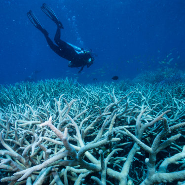
Coral bleaching of the Great Barrier Reef in 2016 was attributed at least partly to an El Nino.Credit:Jason South
How do you identify an El Nino or La Nina?
El Ninos and La Ninas are actually quite common. They occur in a cycle that ranges from two to eight years. The former is slightly more frequent. Events usually last nine to 12 months but some, particularly La Ninas, can linger for two years in a row.
What scientists have settled on for determining whether conditions are in the neutral, El Nino or La Nina phase is the location of relatively warm or cool water in equatorial Pacific.
Scientists divide the Pacific into sections for the purposes of delineating changes in conditions. The section of those waters dubbed “Nino 3.4” is the window they focus on. If waters exceed a certain cool threshold level for at least three months, a La Nina is declared; if the temperatures are warmer than usual by that same rate, it’s El Nino time. It can also be neither, or neutral.
Just what is the threshold varies slightly between agencies. For Australia, the necessary exceedance is 0.8 degrees celsius, while for the US’s National Ocean and Atmospheric Administration, 0.5 degrees suffices.
According to Bureau of Meteorology climate prediction services manager Andrew Watkins, the agency uses multiple NOAA satellites and drifting buoys, and a base period of 1961 to 1990 to set its standard.
“The reason we use 0.8 degrees was from research done by BoM staff many years ago, looking at the best value that matches Australian impacts, which are mostly in our winter and spring,” he says.
“I suspect NOAA uses 0.5 degrees because their impacts are at different times of year to ours, so it better matches their needs.”

The Pacific Ocean, stretching from eastern Australia and Asia to the west coasts of the Americas, covers about a third of the Earth’s surface – and is where La Ninas and El Ninos are formed. Credit:Getty Images
Why does it matter if it's warmer or cooler in the middle of the deep blue sea?
The world’s oceans are absorbing most of the heat we’re emitting globally. During La Nina years, the ocean absorbs more heat; in El Nino events, the ocean processes suck in less heat and may even give it back. Convection or rainfall and cloud cover tend to follow the warm patches, as you can see on the diagrams below. There are three phases of the ENSO pattern, as conditions seesaw between El Nino and La Nina and the neutral stage in between.
During neutral phases of ENSO (above) the easterly trade winds draw up cooler water in the east while warm waters build up to Australia’s north. The winds loop around, across the ocean surface and then up into higher levels of the atmosphere and then back around again in a cycle.
When it’s a La Nina (above), those trade winds are stronger than usual and the warm patch, where air is more likely to rise and create clouds and rain, is pushed closer to Australia. That typically translates into above-average rain in winter and spring for eastern Australia, and a more active than normal tropical cyclone season (which can also bring rain far inland or down the eastern coast).
On the flip side, the El Nino (above), those winds stall or even reverse, leading to warmer water building up in the central Pacific. Air tends to descend rather than rise over eastern Australia, suppressing rainfall and reducing the number of cyclones (whereas over the Americas, there’s likely to be more rain). El Ninos are associated with drought, although drought is not always caused by an El Nino.
As with those Peruvian fisherfolk, the impacts are far-reaching. El Ninos also typically mean very dry spells in Indonesia and Papua New Guinea, for instance, while the southern US is wetter than normal.
Another consequence of El Nino is the Pacific Ocean absorbs less heat than normal or gives some back to the atmosphere, spiking global temperatures in years such as 1998 and 2016. Conversely, La Ninas tend to be cooler years, although with global warming heating up background temperatures, even “cool years” are now relatively warm and often exceed recent El Nino events.

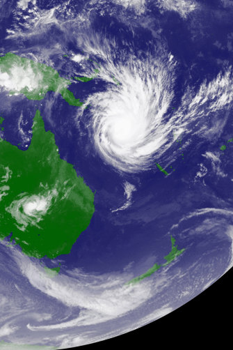
During the 2010-11 La Nina, Cyclone Yasi moves over the Coral Sea before slamming into the Queensland coast.Credit:Japan Meteorological Agency
Do La Ninas develop overnight?
The BoM declared the La Nina to be under way by late September 2020. But those expecting conditions to suddenly change once a threshold level had been crossed would have been disappointed. Rather, incremental changes on an oceanic scale don’t have an immediate effect. Conditions don’t switch overnight – these are subtle changes that take place over weeks and months, building before they take effect – and they can also be moderated or even nullified by interactions with other basins.
And so it was that there were other weather effects under way that temporarily overwhelmed the La Nina. In November, contrary to a typical La Nina period, Australia smashed its temperature records for the month by wide margins. The month broke the previous hottest November maximums by half a degree and mean temperatures were also the warmest by a similar margin.
It was, in short, a most un-La Nina spell up until December – when the MJO lost its mojo and more typical La Nina service resumed.
Rainfall, often a clearer marker than temperature for a La Nina, was also unusually low, at 41 per cent below the 1961-90 benchmark used by the bureau. In fact, the area-averaged 19.19 millimetres of rainfall has been lower in just two other Novembers since 1990.
Watkins says it wasn’t just Australia that was warm. Agencies such as the European Commission’s Copernicus service reported the month was also the hottest November globally. NASA has 2020 tracking to rival 2016 as the hottest year on record.
Another key influence weakening, or even stalling, the impact of La Nina was the absence of a so-called Madden-Julian Oscillation (MJO) in the Australian region. This pattern is an eastward-moving pulse of cloud and rainfall near the equator that typically helps trigger the build-up of the monsoon.
The record of 15 days in Darwin above 35 degrees in November highlighted how relatively warm and dry conditions were in the Top End. The heatwave also cooked eastern Australia, setting state records for NSW and South Australia, and tying them in Victoria.
Watkins says: “You don’t set records in three states without it being a significant heatwave.″ And while the MJO was a near-term influence, the fact that Australia has warmed 1.44 degrees since 1910, “these drivers include climate change”.
It was, in short, a most un-La Nina spell up until December – when the MJO lost its mojo and more typical La Nina service resumed. By then, the bureau had pared back initial projections of a strong La Nina to a moderate event.
Still, residents along the east coast near Byron Bay or the Gold Coast who watched beaches wash away and rivers flood as some places collected about a metre of rain in four days won’t think it very moderate at all.

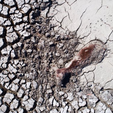
While some of Australia’s worst droughts have been associated with El Ninos, they are not always a factor. The severe dry spell in winter and spring in south-eastern Australia in 2019 had more to do with the Indian Ocean than the Pacific, where conditions were in the neutral ENSO phase.Credit:Nick Moir
What happens when we heat up everything?
The famous greenhouse effect is well known: pump more heat-trapping gases into the atmosphere and everything warms up. However, for complex interactions between the air and oceans, the impacts are difficult to model, not least because they overlay natural fluctuations that run into years and decades. One difficulty is assembling historical data that can help researchers peer long enough into the past to separate a climate signal from the background variability.
The recently published book El Nino Southern Oscillation in a Changing Climate draws on the work of 98 authors to examine how a warming world is already affecting ENSO and what might lie ahead.
The small number of El Ninos and La Ninas with precise data makes teasing out the trend difficult. Still, as the authors say, “there is evidence to
suggest that the impacts of ENSO are being compounded by climate change even now simply because of the super-position of ENSO conditions on a warmer background state”.
Among examples cited are the rainfall extremes in Australia during the 2010-11 La Nina, and the record year for tropical Pacific cyclones and mass coral bleaching on the Great Barrier Reef and beyond during the 2015-16 El Nino.
Agus Santoso, one of the book’s editors and a senior research scientist at the University of NSW, says that one implication is that La Ninas will be easier to produce under global heating. The difference between sea surface temperatures and those at depth will be greater, “facilitating the coupling of winds and upwelling water” necessary to trigger an event, he says.
Current model projections also suggest that the number of extreme El Ninos would double in frequency from one in 20 years to once every decade by the end of this century. For La Ninas, extreme events will go from once every 23 years to once every 13, according to Cai Wenju, a senior CSIRO scientist and another of the book’s authors.
“The worst extremes for Australia may come from El Ninos because they worsen the droughts and severe bushfire seasons that are already under way.”
Santoso, though, says the worst extremes for Australia may come from El Ninos because they worsen the droughts and severe bushfire seasons that are already underway.
One mechanism is that the drying during years of a so-called positive Indian Ocean Dipole, such as in 2019, tends to reinforce an El Nino that is underway in the Pacific. But a negative Indian Ocean Dipole phase does not appear to alter the intensity of a La Nina event if they coincide.
“The El Nino is always stronger than a La Nina,” Santoso says. “It’s not a mirror image.”
Scientists are still understanding what triggers an ENSO event – in 2014, for example, an El Nino was forecast but didn’t arrive (until a year later as the first extreme El Nino of the 21st century). The complexity of the systems being studied means scientists have to be prepared for surprises – and possibly, they won’t be good ones.
“Research has been going on for many decades but we keep getting challenged by what nature throws at us,” Santoso says. “You have to prepare to understand the unknown.”
Let us explain
If you'd like some expert background on an issue or a news event, drop us a line at explainers@smh.com.au or explainers@theage.com.au. Read more explainers here.
Peter Hannam writes on environment issues for The Sydney Morning Herald and The Age.