
AYODHYA: The Ram temple blueprint and map of Ramjanmabhoomi premises received the official nod of the development authority on Wednesday in a rite of passage that opens doors to architects and engineers to kickstart construction.
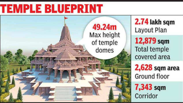
The Ramjanmabhoomi layout plan straddling 67acre mandated by the Supreme Court in its Ayodhya verdict encompasses 2.74 lakh sqm and maximum height of the temple domes was fixed at 49.24 metre in keeping with aviation norms as nearest airport at Faizabad is 6.5km away, said Ayodhya divisional commissioner M P Agrawal. The temple blueprint was passed by Ayodhya Development Authority at its 76th meeting and was chaired by Agarwal.
The Ram Mandir Trust in the temple town deposited Rs 2.113 crore as development charges and Rs 15.4 lakh as labour cess.
‘Rs 2.11 crore transferred online’
According to the Ramjanmbhoomi map, total covered area of the temple will be 12,879sqm with the ground floor spread over 2,628sqm area and the corridor occupying 7,343sqm. The first floor of the covered area would be 1,850sqm and second floor will be 1,056sqm. Dr Anil Mishra, member of Ram Mandir Trust, who attended the meeting, said, the development charges of Rs 2.11crore was transferred online to the Ayodhya Development Authority’s PNB account. To widen the road to the Ramjanmabhoomi, the development authority decided to demolish 400 shops at Naya Ghat on the Saryu banks. Displaced shop owners will be rehabilitated 3km away in Tehri Bazar area of town.

Coronavirus outbreak
Trending Topics
LATEST VIDEOS


City
 Drug link in SSR case: My son wrongly framed, there are bigger names involved, says father of the accused
  SSR death case: Mumbai Police under lens? Central agencies to probe whether Call Data Records were leaked
  With a new turn in SSR case, BJP leader Vishwas Sarang demands dope test for actors
  SSR death: Imtiaz Khatri's alleged role in drug mafia-Bollywood nexus needs to be thoroughly probed, says BJP leader Ram Kadam
More from TOI


Navbharat Times
Featured Today in Travel
Quick Links
Kerala Coronavirus Helpline NumberHaryana Coronavirus Helpline NumberUP Coronavirus Helpline NumberBareilly NewsBhopal NewsCoronavirus in DelhiCoronavirus in HyderabadCoronavirus in IndiaCoronavirus symptomsCoronavirusRajasthan Coronavirus Helpline NumberAditya ThackerayShiv SenaFire in MumbaiAP Coronavirus Helpline NumberArvind KejriwalJammu Kashmir Coronavirus Helpline NumberSrinagar encounter
Get the app