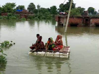
PATNA/KHAGARIA: Over 81 lakh people in 130 blocks of 16 districts were reeling from floodwaters and 5,46,613 had been evacuated to safer places till Sunday. Darbhanga remained the worst hit with its 20,61,700 population under floodwaters, followed by 18,98,738 in Muzaffarpur and 10,19,009 in East Champaran districts. Altogether 81,44,356 people are affected, according to state disaster management department report.
Though major rivers showed a declining trend at some flood gauges, Bagmati and Adhwara group of rivers maintained increasing trend at some places in Sitamarahi and Sheohar districts. The Kosi and Bhutahi Balan were also rising at most of the flood gauges in Supaul, Saharsa, Khagaria and Katihar. The Ganga also had a rising trend in Buxar, Patna, Munger and Bhagalpur.
Light to moderate rainfall occurred at a few places over southern parts of Bihar and at one or two places over northwest parts, but north central parts of the state remained dry during the past 24 hours. Rainfall with thunderstorm is likely at a few places in East Champaran, Siwan, Saran, Gopalganj, Sitamarhi, Darbhanga, Muzaffarpur, Madhubani and some other districts of north Bihar on Monday.
In Khagaria, flood situation continue to remain grim in a large number of riverine villages as major rivers were still flowing above the danger mark. The flood bulletin issued by the district administration on Sunday stated that Kosi, Bagmati and Burhi Gandak were flowing above the danger mark with rising trend while Ganga was flowing below the danger level.
According to official sources, a population 1,38,970 was affected by the floods in 116 villages across 39 panchayats of the district. All the embankments under flood control divoisions under I and 2 are safe, DM Alok Ranjan Ghosh said, adding round the clock strict vigil is being kept by the district administration on all the vulnerable points of different embankments.

Coronavirus outbreak
Trending Topics
LATEST VIDEOS
City
 145 inmates test positive in a day, Thiruvananthapuram central prison remains Covid-19 hotbed
  Hundreds of birds injured due to banned manjha on Independence Day in Delhi
  Karnataka: Terrifying abduction of a woman in broad daylight caught on cam
  Independence Day 2020: Beating retreat ceremony at Attari-Wagah Border as a part of celebrations
More from TOI
Navbharat Times
Featured Today in Travel
Quick Links
Kerala Coronavirus Helpline NumberHaryana Coronavirus Helpline NumberUP Coronavirus Helpline NumberBareilly NewsBhopal NewsCoronavirus in DelhiCoronavirus in HyderabadCoronavirus in IndiaCoronavirus symptomsCoronavirusRajasthan Coronavirus Helpline NumberAditya ThackerayShiv SenaFire in MumbaiAP Coronavirus Helpline NumberArvind KejriwalJammu Kashmir Coronavirus Helpline NumberSrinagar encounter
Get the app


