
CHENNAI/THIRUVANANTHAPURAM: As Mullaperiyar dam level reached 134.7ft on Saturday, about 7 ft short of the maximum permissible level, Kerala has raised concerns about possible inundation of towns downstream of the dam on the Kerala side. The increasing water level in Mullapperiyar dam is a cause for concern, said Kerala power minister M M Mani. “The state government has informed the water level status to Tamil Nadu,” he said.
Kerala’s chief secretary Vishwas Mehta has written to his counterpart in Tamil Nadu, requesting to release water in a phased manner into Kerala when the level in the dam reaches 136ft. Within 36 hours, water level in the dam rose by more than 11ft. TN government had issued the first warning when the level touched 132ft on Friday.
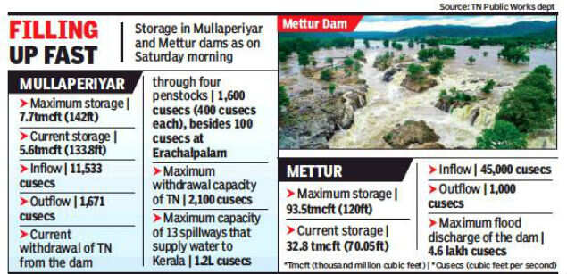
Mehta asked TN chief secretary K Shanmugam to give necessary instructions to officials for releasing water from the dam to Vaigai dam and also requested the government to inform at least 24 hours prior to opening the shutters of the dam. TN is already drawing 1,671 cusecs from the dam, which ultimately goes to Vaigai. Met office has issued red alert for Idukki district on Saturday and Sunday, indicating there could be heavy rainfall in the catchment areas. The inflow into the reservoir was 13,257 cusecs on Saturday evening, Kerala noted.
Mullaperiyar dam’s surplus weir can carry 1.2 lakh cusecs. But instead of releasing huge quantity of water once the dam is full, Kerala wants Tamil Nadu to release water from now onwards in small quantities. Heavy rainfall since Thursday night has already inundated many regions downstream of Mullaperiyar dam on the Kerala side. Sudden release of excess water from the dam can wreak havoc in Vandiperiyar and surrounding areas, as it happened when 28,000 cusecs was released in 2018, Kerala fears.
In Coimbatore district, the bridge constructed across river Gandhaiyaaru to connect Lingapuram with five other villages in Mettupalayam taluk was submerged on Saturday. This is the third year in succession that the bridge gets submerged during Monsoon. There is 2.5 ft water above the bridge, forcing residents to use coracles to cross the 300-meterwide river. Over 300 families residing in Gandhavayal, Mokkamedu, Alur, Melur and Ulliyur and over 450 acres of farmland have been cut off. Their only alternative route is through thick forest, said L K Thirumugam, a resident of Gandhavayal. The bridge remains submerged for five to six months in a year, said M Ammasaikutti, a farmer in Lingapuram. The bridge was constructed at a height of 110 feet in 2004 against the villagers’ demand to increase the height by another 10ft to avoid flooding.
Kerala’s chief secretary Vishwas Mehta has written to his counterpart in Tamil Nadu, requesting to release water in a phased manner into Kerala when the level in the dam reaches 136ft. Within 36 hours, water level in the dam rose by more than 11ft. TN government had issued the first warning when the level touched 132ft on Friday.
Mehta asked TN chief secretary K Shanmugam to give necessary instructions to officials for releasing water from the dam to Vaigai dam and also requested the government to inform at least 24 hours prior to opening the shutters of the dam. TN is already drawing 1,671 cusecs from the dam, which ultimately goes to Vaigai. Met office has issued red alert for Idukki district on Saturday and Sunday, indicating there could be heavy rainfall in the catchment areas. The inflow into the reservoir was 13,257 cusecs on Saturday evening, Kerala noted.
Mullaperiyar dam’s surplus weir can carry 1.2 lakh cusecs. But instead of releasing huge quantity of water once the dam is full, Kerala wants Tamil Nadu to release water from now onwards in small quantities. Heavy rainfall since Thursday night has already inundated many regions downstream of Mullaperiyar dam on the Kerala side. Sudden release of excess water from the dam can wreak havoc in Vandiperiyar and surrounding areas, as it happened when 28,000 cusecs was released in 2018, Kerala fears.
In Coimbatore district, the bridge constructed across river Gandhaiyaaru to connect Lingapuram with five other villages in Mettupalayam taluk was submerged on Saturday. This is the third year in succession that the bridge gets submerged during Monsoon. There is 2.5 ft water above the bridge, forcing residents to use coracles to cross the 300-meterwide river. Over 300 families residing in Gandhavayal, Mokkamedu, Alur, Melur and Ulliyur and over 450 acres of farmland have been cut off. Their only alternative route is through thick forest, said L K Thirumugam, a resident of Gandhavayal. The bridge remains submerged for five to six months in a year, said M Ammasaikutti, a farmer in Lingapuram. The bridge was constructed at a height of 110 feet in 2004 against the villagers’ demand to increase the height by another 10ft to avoid flooding.

Coronavirus outbreak
Trending Topics
LATEST VIDEOS
City
 Kozhikode air mishap: Findings of the investigation will be made public, says Civil aviation minister Hardeep Singh Puri
  Delhi govt soon to release draft policy to accelerate growth of startups, CM Kejriwal begins talks
  Kozhikode air crash: Digital flight data recorder, cockpit voice recorder recovered, says Civil Aviation Minister
  Kerala air crash: What actually happened at the Kozhikode airport yesterday
More from TOI


Navbharat Times
Featured Today in Travel
Quick Links
Kerala Coronavirus Helpline NumberHaryana Coronavirus Helpline NumberUP Coronavirus Helpline NumberBareilly NewsBhopal NewsCoronavirus in DelhiCoronavirus in HyderabadCoronavirus in IndiaCoronavirus symptomsCoronavirusRajasthan Coronavirus Helpline NumberAditya ThackerayShiv SenaFire in MumbaiAP Coronavirus Helpline NumberArvind KejriwalJammu Kashmir Coronavirus Helpline NumberSrinagar encounter
Get the app