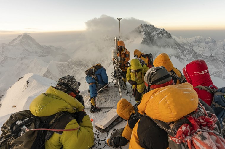
 Team Expedition Everest set up a weather station on Mount Everest. (Source: National Geographic)
Almost all the ice in the Himalaya, which supplies water to hundreds of millions downstream, is found between 5,000 and 8,000 meters, yet we know almost nothing about what the current climate is like up there, says climate scientist and National Geographic explorer Tom Matthews.
To better our understanding of climate change, Mathews along with a team of sherpas and climate scientists Baker Perry, Mariusz Potocki, Tenzing Chogyal Sherpa and Tracie Seimon embarked on a journey called ‘Expedition Everest’ in 2019 to install a network of weather stations on Mount Everest, including the highest weather station on Earth at 27,600 feet above sea level.
The purpose behind the project was to perform a detailed scientific assessment of Mount Everest through establishing these weather stations, and crucially, through that, monitor climate variables at elevations critical for regional water resources and how glaciers will respond to future warming.
The team spoke with the indianexpress.com on their struggle with extreme weather, traffic jams enroute, and physically working at altitudes above 8,000 meters, among others.
‘Expedition Everest’ will premiere on July 18 at 10 pm on National Geographic.
Q. What are some of the specific observations your team made during the expedition?
Tom Mathews: There is clear evidence of glacier retreat in the region – if you know where to look. Like the high-water mark left in a bathtub, you can see on the mountain slopes where the glacier surface used to sit. During the expedition we saw evidence that the Khumbu glacier now sits tens (or even hundreds) of metres below this mark.
We also saw evidence of an interesting and quite concerning phenomena. We observed widespread melting going on during our climb – meltwater rivers to jump over at Camp II (about 6,500 m above sea level), for example. The air temperatures never climbed above freezing up there during that time of the year, so it was a surprise to see so much melt. The weather station data have since helped us understand this better – it is the intense sunshine that heats the snow/ice surface up to be quite a bit warmer than the air. This is a concern because if it is already melting up there, it means the region’s glaciers may be even more sensitive to climate warming than previously thought.
Q. What’s the rationale behind studying climate change on Everest between 5,000-8,800 meters?
 While we were on the mountain, rampant upper respiratory infections and dry cough (Khumbu cough) impacted nearly everyone on our team and substantially delayed and slowed our ascent. Additionally, traffic jams prevented our team from climbing as high as we intended, said Baker Perry. (Source: National Geographic)
Tom Mathews: Almost all the ice in the Himalaya – ultimately supplying water to hundreds of millions downstream – is found between 5,000 and 8,000 meters, yet we know almost nothing about what the current climate is like up there, how it has changed in the longer-term past, and how contemporary climate change is playing out. These details matter urgently if we are to understand how the glaciers (and water resources) will respond to future warming. It takes a multi-disciplinary effort to answer this question – from ice cores and geological clues about past glacier changes – to real-time measurements from weather stations.
From the weather station side, there were strong motivations to perform an installation above 8,000m – as close to the summit as possible. The higher we could get, the more likely it was that we could take direct measurements of the upper atmosphere winds – which encircle the Earth and drive impactful weather fluctuations far and wide. Bad weather also contributes to around 25 per cent of deaths on Everest, and mountaineers are particularly exposed on the upper slopes. Our direct observations from the high-altitude stations lay the foundations to improve forecasting of dangerous weather – potentially saving lives.
Q. Could you explain the impact of climate change on Everest on the communities that live downstream and natural habitats that it supports?
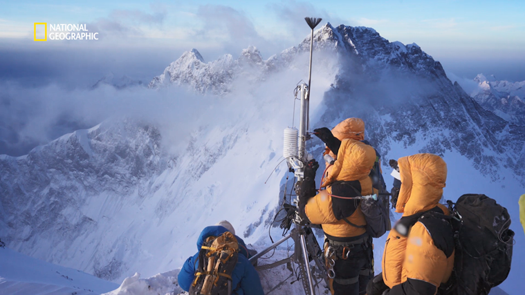 The idea is to establish monitoring of climate variables at elevations critical for regional water resource monitoring where major data voids have existed, said climate scientist Baker Perry from the Expedition Everest team. (Source: National Geographic)
Tracie Simon: What we found on Mt Everest, the apogee of the Hindu Kush Himalaya mountain system seems to match observationally with what we have observed in the world’s other great high-mountain range, the Andes of South America. At the uppermost reaches of the biosphere — Earth’s life zone — the alpine ecosystem is expanding to occupy terrain being exposed by rapidly diminishing ice cover as mountain glaciers melt away. In the tropical Andes, our research team has documented this process over repeated visits to the same sites over several decades to establish rates of expansion. On Mt Everest, we have started with an initial snapshot of data from just one year, and we must fill in the knowledge gaps with additional data through repeated visits and using photographs from past expeditions and images from satellites that help us place our observations into longer-term contexts.
We also recorded a multitude of life forms on Mt Everest in what looks like a relatively barren zone between the tree-line and the snowfields lying above. Indeed, there are far more life forms existent there than has ever been documented at comparable elevations worldwide.
Our findings highlight the value and significance of performing detailed scientific studies on Earth’s highest mountain. More than being an icon for its superlative height and global fascination, Mt Everest stands to inform us of the state of changing environments throughout the Hindu Kush Himalaya ranges, and in high mountain regions of the world more generally, as well as the need for humans dwelling in these ranges to adapt their land use and agricultural practices to adjust to changes that may not be easily discerned without careful monitoring and scientific insights.
Q. What were the major challenges establishing a weather station on Mt Everest?
Baker Perry: One of the first things we had to consider was how to engineer the weather stations. They needed to a) be light enough to be carried but strong enough to survive extreme winds, b) be set up very quickly will minimal need for finger dexterity, c) have redundancy in key sensors in case one failed due to the conditions, and d) capable of conserving power when battery voltage dropped below critical thresholds. The physical preparation for the expedition required 15-20 hours of training (fitness and strength) per week to be prepared to climb above 8,000 m and work at that elevation.
While we were on the mountain, rampant upper respiratory infections and dry cough (Khumbu cough) impacted nearly everyone on our team and substantially delayed and slowed our ascent. Additionally, traffic jams prevented our team from climbing as high as we intended. When we went to install the highest weather station, low temperatures (-25 C) at the Balcony rendered drill batteries inoperable and we were forced to warm the batteries inside down suits for ~ 1 hr. The area at the Balcony where we were working was very small and we had to work with dangerous exposure on all sides and an unstable cornice. Our final challenge was that the mounts for the station’s wind sensors were left at South Col (Camp IV) so we had to improvise with pieces from our shovel handle.
Q. What do you hope to achieve through weather stations on Mt Everest?
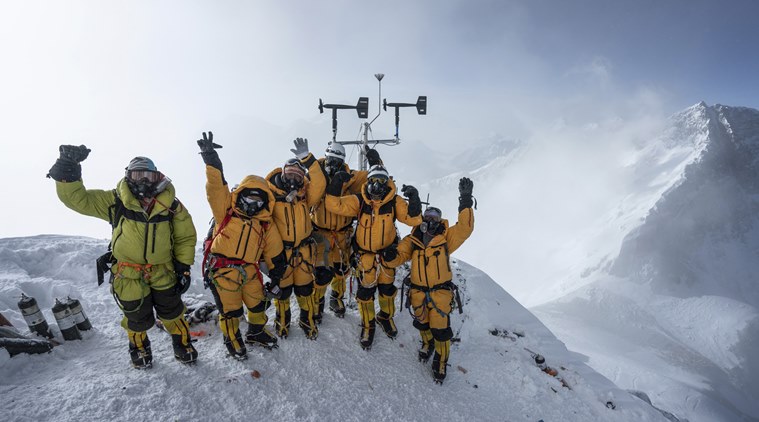
 The Expedition Everest Team setting up a weather station. (Source: National Geographic)
Baker Perry: The idea is to establish monitoring of climate variables at elevations critical for regional water resource monitoring where major data voids have existed. The stations allow us to provide continuous monitoring of jet stream winds that are a globally significant circulation feature that may be changing in strength and location as climate warms. This monitoring will allow us to improve weather forecasts during the climbing season and help improve climbing safety. Further, data from the stations will provide meteorological context for interpretation of the world’s highest ice core.
Q. You (Tenzing Chogyal Sherpa) are from Namche Bazaar on the foothills of Everest. There’s evidence that climate change is already affecting communities that live downstream. What are some of those changes you are already seeing in your own community due to the changing climate on Everest?
Tenzing Chogyal Sherpa: One of the most pronounced effects of climate change in the Khumbu region is the rapid melting of glaciers. The glaciers in this region have already lost 13 per cent of their total area in the last three decades. What’s more alarming is the rate of melting, which has accelerated in recent years.
The rapid melting of these glaciers brings about numerous associated risks for the people and environment in the region, the most prominent being the formation of glacial lakes. The formation of glacial lakes poses great risks to downstream communities due to their potential to cause outburst floods. There are already more than 340 glacial lakes in the region, with two of them considered potentially dangerous glacial lakes. The region has already faced numerous glacial lake outburst floods (GLOFs), among which the Dig Tsho GLOF of 1985 was particularly destructive. In addition to destroying settlements downstream, this event also led to the complete destruction of a newly constructed mini hydropower station and was one of the most consequential events of the time.
The other implication of climate change for the region has been in terms of water availability. Much of the drinking water used in the villages of Namche, Khumjung and Khunde, which are the largest villages in the region, comes from a glacier 10 kilometres north, called Gyajo Glacier. However, this glacier has been rapidly losing mass and continues to recede at an alarming rate.
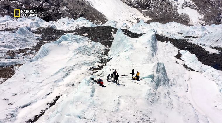
Q. You developed and conducted the ice-core drilling at Everest to collect samples that would help you study the composition of atmosphere during pre-industrial times and also help in establishing a baseline on climate trends. What were your challenges in conceptualising and implementing this idea to obtain data from an ice core?
Marius Potocki: From the beginning, one of the major goals of this project was to collect a useful Everest ice core from the highest location possible. Ice cores are a little like time capsules in that they tell us stories about atmospheric changes in the past. Until we drilled on South Col, no one had ever studied an ice core from above 7000 meters a.s.l. The Everest South Col ice core, drilled at an elevation of 8020 meters a.s.l., is unique because it contains a record of past atmospheric changes at that elevation. Based on the ice core data, we hope to reconstruct such things as changes in the location of the Jetstream and intensity of the monsoon back through time.
Because the drill site was so remote and at such high elevation, we had to consider every little detail and plan for all eventualities. For example, what type of drill could recover ice at that elevation; what type of power system would be reliable in those conditions; how should the ice be packed and transported; and many other things that likely make the difference between success and failure.
Climbing that high, the biggest risks are low temperature, strong winds, and lack of oxygen. However, based on the experience of generations of past climbers we prepared for the altitude as best we could. By far, the greatest physical challenge was to work for an extended period of time at that elevation and use a drilling system that had never before been tested at that altitude. The biggest unknowns in terms of ice core recovery were the drill power system and the quality of the South Col ice. Before the expedition, we tested our drilling gear in a lab freezer at low temperature (-25C). We also tested and modified the drill on a glacier in Iceland. Ultimately, there are many things that may negatively affect the drilling process and we did our best to mitigate these to the best of our abilities. However, until the very last moment, there is always a hint of doubt as to how things will go.