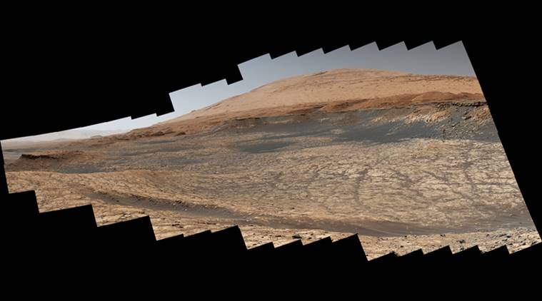
 Curosity Mars Rover’s path for the next road trip stitched together from 116 images (Source: NASA)
The summer road trip of National Aeronautics and Space Administration’s (NASA) Curiosity Mars rover is underway. The Mars rover will complete a total of 1.6 km during its yearly road trip.
As the road trip kicked off on July 6, Curiosity Mars Rover sent a few images of the next destination. The plan is to avoid getting stuck in a vast patch of sand before it moves to the next part of the mission, a mountain called Mount Sharp. The mission’s aim is to study the sediments of Mount Sharp.
The image posted is a combination of a total of 116 images sent. It is the path Mars rover will take to the floor of the Gale crater which will release new details about the climate change that took place on the planet three million years ago.
The five-kilometer tall Mount Sharp’s sedimentary layer will help to reveal the truth of Red Planet. It may shed light on how a planet with an Earth-like ecosystem with lakes, streamers, and a thicker atmosphere to a frozen desert that it is today.
The speed at which Mars Rovers travels ranges from 25 to 100 metres per hour. The lower part of the mountain has already been explored. In 2019, the scientists called the lower side as a “clay-bearing unit” as it revealed the highest amount of clay minerals earlier. The two samples drilled by the rover were named as “Aberlady” and “Kilmarie”.
The scientists believe that the clay is an indicator of water bodies in the Gale crater, possibly an ancient lake.
NASA’s rover planners expect the rover to reach the area in early fall. As there is a lack of terrain imagery, the trip will be completed using rover’s automated driving abilities as it finds the safest path on its own.
“Curiosity can’t drive entirely without humans in the loop,” said Matt Gildner, lead rover driver at JPL. “But it does have the ability to make simple decisions along the way to avoid large rocks or risky terrain. It stops if it doesn’t have enough information to complete a drive on its own.”
Earlier this week, NASA released an image of Mars’ closest and biggest moon ‘Phobos’. Also, the European Space Agency (ESA) posted a video of Mars’ Korolev crater on Youtube which is also known as icy Martian canyon.