
MUMBAI: Mumbaikars woke up to a steady downpour that continued through Thursday morning as the tail of Cyclone Nisarga brought more rain to the city than when it made landfall near Murud-Janjira, 85km southeast of Mumbai, on Wednesday.
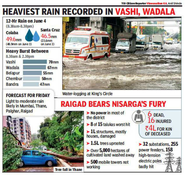
By afternoon, the rain ---the heaviest was in Navi Mumbai (see box) --- subsided. In six hours on Thursday between 8.30am and 2.30pm, the rain recorded at Colaba was 49.4mm and 42mm at the Santa Cruz observatory, compared to 50mm and 24.8mm, respectively, in June3-4
(8.30am-8.30am) when the cyclone passed.
Unlike Wednesday, when the city witnessed gusty winds reaching up to 76 kmph, the wind speed on Thursday was a mellow 14.8 kmph.
Shubhangi Bhute, scientist at IMD Mumbai, attributed the rain to “remnants” of the cyclone. “The cyclonic storm Nisarga has weakened into a deep depression which further weakened into a depression over west Vidarbha at 5.30pm of June 4. It was expected to move east-northeastwards and weaken into a wellmarked low pressure area,” said the IMD official.
Mahesh Palawat of private weather forecasting agency Skymet explained that the “outer peripheral wall of the storm had remained in sea and the strong south westerly winds had pushed up the moisture content leading to formation of thunder clouds which gave these intense showers”.
Usually, the intensity of rainfall is expected to reduce once a storm has made landfall, and IMD had forecast light to moderate rain for Thursday.
Importantly, Palawat said the storm had not disturbed the monsoon currents, and models indicate there is unlikely to be much of a delay in its arrival. The official date for the onset of monsoon over Mumbai is June 11. “Onset can be expected for the city between June 11 and 13 as winds continue to stay westerly and monsoon currents have not been disturbed,” he said.

Coronavirus outbreak
Trending Topics
LATEST VIDEOS

City
 Kerala pregnant elephant killing: Preliminary post-mortem reports out
  Bigger tremors round the corner in Delhi-NCR?
  2,550 foreign Tablighi Jamaat members blacklisted by Home Ministry; entry into India banned for 10 years
  Justice will prevail: Kerala CM Pinarayi Vijayan on killing of pregnant elephant
More from TOI


Navbharat Times
Featured Today in Travel
Get the app