 Climatologically, formation of cyclones during pre-monsoon or just prior to monsoon onset is considered normal, said the IMD chief. (Source: IMD/Facebook)
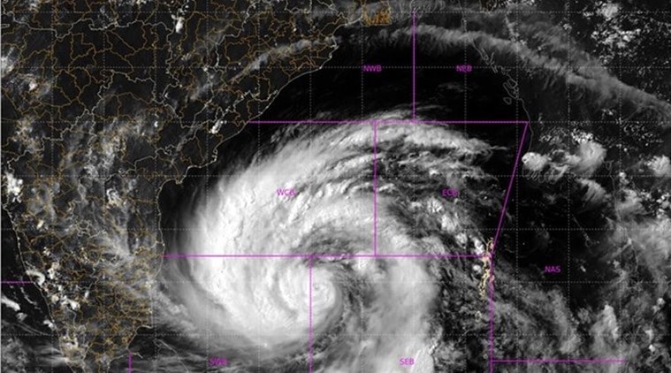
Cyclone Amphan (pronounced Um-Pun) is only the second Super Cyclone to have formed in the Bay of Bengal in the last two decades, said Mrutyunjay Mohapatra, director general, India Meteorological Department (IMD).
Mohapatra was speaking about tropical storms during a Facebook Live session organised by the Ministry of Earth Sciences (MoES) on Monday.
“Super Cyclone Amphan intensified very rapidly in the 24 hours between evening of May 17 and May 18. Though there have been two or three super cylones in the past, Super Cyclone Amphan is only the second after the Odisha Super Cyclone of 1999 to form in the North Indian Ocean. The Odisha Super Cyclone remains the strongest cyclone in the history of cyclones in this region,” said Mohapatra.
Covering an area of 700 km and measuring 15 km in height, Super Cyclone Amphan is not only massive in size but also moving at a very high speed of 220-230 kmph as on Monday evening.
Climatologically, formation of cyclones during pre-monsoon or just prior to monsoon onset is considered normal, said the IMD chief.
“The Bay of Bengal records at least five cyclones in a year of which one is formed during the May-June period and the other four are formed during October-December period. Sea surface temperature (SST) is one of the key elements that determines the formation of cyclones. Since SSTs are high during summer months, conditions are favourable for cyclone formation in May and June,” Mohapatra added.
He said that Super Cyclone Amphan is expected to make landfall along Digha in West Bengal and Hatiya islands of Banglagesh by the evening of May 20.
“The wind speed when it hits land would be 165-175 kmph gusting to 195 kmph. Districts in West Bengal, including east and west Mednipore, south and north 24 Parganas, Howrah, Hoogli and Kolkata would be affected severely,” he said.
This super cyclone, which was tracing a path parallel to the Odisha coast, will also bring heavy to very heavy rainfall over districts of Jagatsinghpur, Balasore, Kendrapara, Bhadrak and Mayurbhanj along coastal Odisha on Monday and Tuesday.
The eye of the super cyclone, measuring up to 120 km, is expected to cross the Sundarbans in West Bengal in less than 48 hours, Mohapatra said.
“We expect tidal waves as high as 4 to 6 metres, as tall as a two storied building at landfall. Since the cyclone will be passing through the Sundarbans and deltaic areas, houses in these areas would be affected by saline water brought in by these waves,” said Mohapatra, who is also known as the ‘Cyclone Man of India’