 Cyclone Amphan LIVE Update: It is reportedly moving at a speed of 14 kmph. (Source: IMD)
Weather forecast Today, Cyclon Amphan Live Updates: Super Cyclone Amphan will weaken into an ‘Extremely Severe Cyclonic Storm’ within the next six hours, the India Meteorological Department (IMD) said. It is moving at a speed of 14 kmph towards the coasts of Odisha and West Bengal. At 2.30 am, it lay 570 km south of Odisha’s Paradip, 720 km south-southwest of Digha in West Bengal and 840 km south-southwest of Khepupara in Bangladesh. The storm is expected to make landfall along Digha in West Bengal by the evening of May 20.
Union Home Minister Amit Shah spoke to the chief ministers of West Bengal and Odisha, Mamata Banerjee and Naveen Patnaik respectively, and assured them of help, if needed.
The Indian government Monday said the cyclone had the potential to cause extensive damage like Cyclone Fani, which hit India at this time last year. Prime Minister Narendra Modi chaired a meeting on Monday to review the response preparedness and evacuation plan presented by the National Disaster Response Force (NDRF).
At least 25 NDRF teams have been deployed on the ground while 12 others are ready in reserve. An additional 24 teams are also on standby in different parts of the country. Apart from the NDRF, the Odisha Disaster Rapid Action Force (ODRAF) and Fire Services are in action too.
Union Home Minister Amit Shah spoke to West Bengal Chief Minister Mamata Banerjee this morning, and assured her help to deal with Cyclone Amphan.
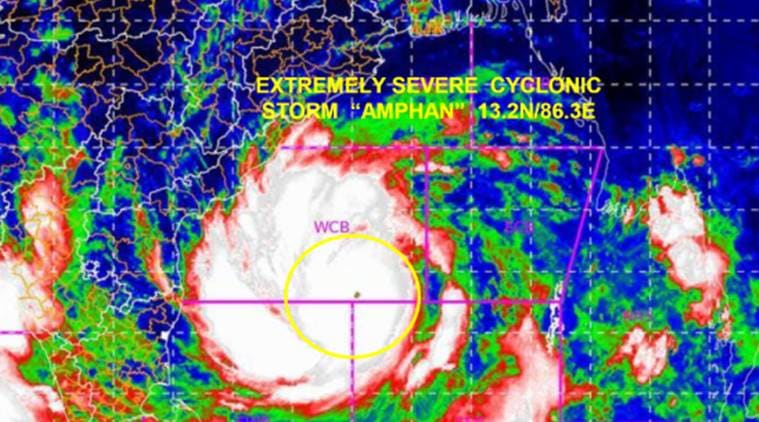
Last night, Cyclone Amphan was captured by Japan’s Himawari-8 satellite as it headed for India and Bangladesh. Here's a look at it:
The Tripura government has directed District Magistrates to be prepared to handle any high impact of Cyclone Amphan. Despite the fact that IMD has not issued a warning for Tripura, the state government said "there is no certainty of movement of exact path of the cyclone", reported news agency ANI.
Super Cyclone Amphan is expected to weaken into an ‘Extremely Severe Cyclonic Storm’ within the next six hours, stated the India Meteorological Department (IMD). As an Extremely Severe Cyclonic Storm, the wind speed will continue to remain high and range between 200-210 kmph.
Adopting names for cyclones makes it easier for people to remember, as opposed to numbers and technical terms. Apart from the general public, it also helps the scientific community, the media, disaster managers etc. With a name, it is easy to identify individual cyclones, create awareness of its development, rapidly disseminate warnings to increased community preparedness and remove confusion where there are multiple cyclonic systems over a region. While picking names for tropical cyclones, there are rules that need to be followed.
Residents in coastal districts of Ganjam, Gajapati, Puri, Jagatsinghpur, Kendrapara, Bhadrak, Balasore, Mayurbhanj, Jaipur, Cuttack, Khurda and Nayagarh in Odisha have been asked to prepare for evacuation if necessary. The Center had Monday asked states to evacuate people from low lying areas in the cyclone path. Here are some pictures by news agency ANI from an evacuation centre in Odisha:
The West Bengal government is evacuating residents along coastal areas to cyclone centres. On May 20, the storm is likely to impact East Medinipur, South & North Parganas, Hoqrah, Hooghly and Kolkata. Teams of NDRF have been deployed in these regions to carry out relief work. They are equipped with boats, tree cutters, telecom equipment etc. Rescue teams of the Army, Navy, Indian Air Force and Coast Guard are also on standby.
Heavy to extremely heavy rainfall is predicted in the coastal districts of West Bengal on May 19 and 20. Coastal districts of Odisha, meanwhile, can expect heavy to very heavy rainfall.
On Tuesday, coastal districts Medinipur, South and North 24 Parganas are likely to receive light to moderate rainfall at many places, and heavy falls at isolated places. In Odisha, very to very heavy rainfall is expected in Jagatsinghpur, Kendrapara, Jajpur, Balasore, Bhadrak and Mayurbhanj, while isolated heavy falls are expected in Khordha and Puri districts.
Super cyclone Amphan is expected to make a landfall along Digha and Hatiya islands in Bangladesh cutting through the Sundarbans in the afternoon or evening of Wednesday, May 20. At the time of landfall, it will remain an 'Extremely Severe Cyclonic Storm', with wind speeds ranging between 165-175 kmph to to 195 kmph.
Super cyclone Amphan is moving at the speed of 14 kmph. At 2.30 am, it lay 570 km south of Paradip, Odisha; 720 km south-southwest of Digha in West Bengal and 840 km south-southwest of Khepupara in Bangladesh.
Cyclone Amphan is only the second super cyclone to form in the North Indian Ocean after the Odisha super cyclone of 1999. There have been two or three super cyclones in the past. The government, which is evacuating coastal residents, has said Cyclone Amphan has the potential to cause extensive damage like Cyclone Fani, which hit India at this time last year.
Good morning. We are tracking Cyclone Amphan, a super cyclone off the coasts of Odisha and West Bengal in the Bay of Bengal. The super cyclone was moving at a speed of 14 kmph. At 2.30 am, it lay 570 km south of Paradip, Odisha; 720 km south-southwest of Digha in West Bengal and 840 km south-southwest of Khepupara in Bangladesh.
Cyclone Amphan, which turned into a "super cyclonic storm" on Monday and is expected to make landfall on May 20, is being taken seriously as this is only the second such severe cyclone that would hit India after 1999, NDRF chief S N Pradhan said. It has the potential to cause extensive damage like 'Fani' in the coastal districts of West Bengal when it finally makes the landfall on Wednesday, the government said.
To take a stock of the measures being taken to prevent major damage by the cyclone, Prime Minister Narendra Modi held a high-level meeting and reviewed the response preparedness and evacuation plan presented by NDRF, said PMO. During presentation by National Disaster Response Force, DG NDRF apprised the prime minister of the precautionary initiatives they took so far: 25 NDRF teams have been deployed on the ground while 12 others were ready in reserve. Additional 24 NDRF teams were also on standby in different parts of the country.
Met dept warned of storm surge of 4-6 meter height above astronomical tide, will inundate low lying coastal areas of WB during landfall. Cyclonic storm also likely to impact North Odisha coastal districts including Jagatsinghpur, Kendrapada, Bhadrak and Balasore districts, said government. (PTI)
Cyclone "Amphan" has developed into a super cyclone in the Bay of Bengal on Monday and has the potential to cause extensive damage in the coastal districts of West Bengal when it makes landfall on Wednesday, the government said. According to a PTI reports, the cyclone is expected to make landfall on the West Bengal coast in the afternoon of May 20 as an extremely severe cyclonic storm with wind speeds ranging up to 195 kmph. The cyclone has the potential to cause extensive damage in the coastal districts of West Bengal, an official statement said.
'Amphan', categorised as a super cyclone, is expected to make landfall on May 20 and it is being taken seriously as this is only the second time that such a severe cyclone will hit India after 1999, NDRF chief S N Pradhan said on Monday. Pradhan said 'Amphan' will be an extremely severe cyclonic storm, a notch below the 'super cyclone' category, when it makes landfall.
The National Disaster Response Force (NDRF) chief said the coming cyclone is a "serious" one as it is only the second time after 1999 in Odisha that a storm hitting the country's coast has been categorised as a 'super cyclone'. The 1999 super cyclone was very deadly and it is expected that Amphan upon landfall will be like the 'Fani' cyclone that hit the Odisha and Andhra Pradesh coasts in May 2019. (PTI)
Cyclone Amphan (pronounced as Um-Pun) is only the second Super Cyclone to be formed in the Bay of Bengal in the last two decades said Mrutyunjay Mohapatra, director general, India Meteorological Department (IMD). Mohapatra was speaking about tropical storms during a Facebook live session organised by Ministry of Earth Sciences (MoES) on Monday. "Super cyclone Amphan intensified very rapidly during the 24 hours between evening of May 17 and May 18. Though there have been two or three Super Cylones in the past, Super Cyclone Amphan is only the second after the Odisha Super Cyclone of 1999 to form in the North Indian Ocean. The Odhisha Super Cyclone remains the strongest cyclone in the history of cyclones formed in this region," said Mohapatra. — A report by Anjali Marar
With super cyclone Amphan likely to hit West Bengal on May 20, the Mamata Banerjee government has started evacuated locals from coastal areas and put government officials on 24x7 work mode. Chief minister Mamata Banerjee has put district magistrates of South 24 Parganas, North 24 Parganas and East Midnapore, which are likely to witness maximum damage, on high alert and dispatched disaster management teams to coastal areas. Addressing media, Banerjee also expressed her displeasure after the resident commissioner on West Bengal in Delhi was called for meeting with Union Home Minister on cyclone situation without intimating her government.
During presentation by National Disaster Response Force, DG NDRF informed PM Modi that 25 NDRF teams have been deployed on the ground while 12 others were ready in reserve. Additional 24 NDRF teams were also on standby in different parts of the country.