 Fooling Google Maps with 99 phones and a wagon? Here’s how this Berlin-based artist achieved it. (Image source: Screenshot from YouTube)
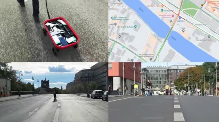
Is it possible to fool or hack Google Maps into showing a traffic jam when it does not really exist? Well that’s the experiment that Berlin-based artist Simon Weckert decided to try and it appears he was successful in tricking one of the most useful Google tools. And all he needed was a little wagon loaded with 99 smartphones all of which had navigation turned on for this purpose.
Weckert’s performance art was designed to generate a virtual traffic jam in Google Maps by moving around with this wagon which was filled with phones. While Weckert moved slowly down the street just dragging his phone-laden wagon, Google Maps ended up interpreting this as slow moving traffic and marked that particular street as red on the map.
Red means the traffic is particularly bad, yellow is slow moving traffic and green means all clear on Google Maps. The service does rely on real-time location data from phones to determine which street might have a traffic jam.
Weckert has posted the video on YouTube as well, which has managed to get one million views since being shared on February 1,2020. In his post around this ‘Google Hack’, he notes that “through this activity, it is possible to turn a green street red, which has an impact in the physical world by navigating cars on another route to avoid being stuck in traffic.”
He has also posted images on his websites, and you can see that the street where he is dragging his wagon appears as red on Google Maps, while the road is actually totally empty. Check out the YouTube video below:
Google has since then issued a response to this prank hack of Google Maps, noting that this is particular use case shows further ways in which Maps needs to improve on traffic data.
In a statement to 9to5Google, the company said, “Whether via car or cart or camel, we love seeing creative uses of Google Maps as it helps us make maps work better over time.”
They also clarified that traffic data in Maps is “refreshed continuously thanks to information from a variety of sources, including aggregated anonymized data from people who have location services turned on and contributions from the Google Maps community.”
While in India, Indonesia and Egypt, Google can differentiate between motorcycles and cars, the statement adds the company has not “quite cracked traveling by wagon,” which is what fooled Maps in the end. This would explain why Maps turned red when so many phones with navigation turned on were all present in one location.