
PUNE: The faulty blue and red lines in the existing development plan triggered mushrooming of illegal constructions on the city’s riverbeds and a serious view should be taken on such structures, stressed activists.
Activist Sarang Yadavadkar said the irrigation department had handed over the marking details to the Pune Municipal Corporation (PMC) in 2011, but they were shifted during the digitization programme.
The fallout was dangerous. “No development zone(s)” were converted to residential zone(s), prompting haphazard constructions across these locations,” said Yadavadkar.
However, he added that people facing inundation in their homes should not be blamed. This problem remains the fault of the authorities who let it happen, Yadavadkar stressed. “Unless stringent action is taken against officials responsible for these problems, there won’t be any change,” he said.
Activists across the city, after observing the inundation of the structures over the past few days, stated that the shifting of the flood lines prompted the local authorities — the corporations, Pune Metropolitan Region Development Authority (PMRDA) and the collectorate — to give sanctions for construction in those areas.
Activist Satish Khot said the heavy discharge of water from the dams exposed that there were many cases of violation of the blue and red lines, particularly in the east of Sangam, and the corporation had to take action for the same. “If there is any discrepancy in the blue and flood lines in the digitized maps, it should be corrected, and action should be taken against the unauthorized structures,” he said.
Senior revenue officials stated that the local authorities should undertake fresh surveys of sites and action should be taken against such structures.
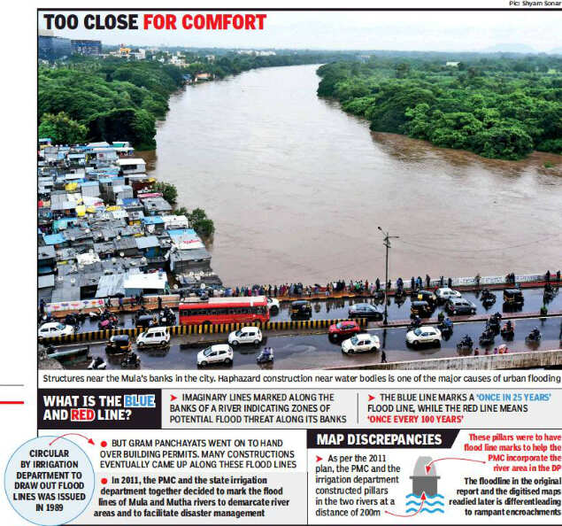
The blue and red lines are imaginary lines marked on the banks of a river indicating the potential flood threat zones. The blue line marks a “once in 25 years” flood line, while the red line means “once in 100 years”. A state government circular from 1989 had prompted the irrigation department to define the high flood lines of the Mutha river. The department officials then surveyed the 27km stretch of the river from Khadakwasla to Kharadi and gave all the details.
Activists pointed out that before it was done, residential constructions had come up within these limits and societies were at risk. Khot said a survey carried out with the Pune Municipal Corporation officials revealed many buildings were in these areas.
Residents staying in such areas complained that those places were not within the corporation limits. Some other officials allegedly gave them the nod to build. “They should be blamed. Why should citizens suffer?” asked a resident of the Sinhagad Road area.
Developers stated that they had taken permission as per rules. “The flood lines are followed as per the DP. If the flood line marking is wrong, how can we be blamed?”
Illegal construction near waterbodies has plagued our cities before. Rapid urbanisation in locations that stand over wetlands, floodplains, or riverbeds helped aggravate the floods in Mumbai in 2005 and 2017, Uttarakhand in 2013, Srinagar in 2014, Chennai in 2015 and in Kerala last year.
Activist Sarang Yadavadkar said the irrigation department had handed over the marking details to the Pune Municipal Corporation (PMC) in 2011, but they were shifted during the digitization programme.
The fallout was dangerous. “No development zone(s)” were converted to residential zone(s), prompting haphazard constructions across these locations,” said Yadavadkar.
However, he added that people facing inundation in their homes should not be blamed. This problem remains the fault of the authorities who let it happen, Yadavadkar stressed. “Unless stringent action is taken against officials responsible for these problems, there won’t be any change,” he said.
Activists across the city, after observing the inundation of the structures over the past few days, stated that the shifting of the flood lines prompted the local authorities — the corporations, Pune Metropolitan Region Development Authority (PMRDA) and the collectorate — to give sanctions for construction in those areas.
Activist Satish Khot said the heavy discharge of water from the dams exposed that there were many cases of violation of the blue and red lines, particularly in the east of Sangam, and the corporation had to take action for the same. “If there is any discrepancy in the blue and flood lines in the digitized maps, it should be corrected, and action should be taken against the unauthorized structures,” he said.
Senior revenue officials stated that the local authorities should undertake fresh surveys of sites and action should be taken against such structures.
The blue and red lines are imaginary lines marked on the banks of a river indicating the potential flood threat zones. The blue line marks a “once in 25 years” flood line, while the red line means “once in 100 years”. A state government circular from 1989 had prompted the irrigation department to define the high flood lines of the Mutha river. The department officials then surveyed the 27km stretch of the river from Khadakwasla to Kharadi and gave all the details.
Activists pointed out that before it was done, residential constructions had come up within these limits and societies were at risk. Khot said a survey carried out with the Pune Municipal Corporation officials revealed many buildings were in these areas.
Residents staying in such areas complained that those places were not within the corporation limits. Some other officials allegedly gave them the nod to build. “They should be blamed. Why should citizens suffer?” asked a resident of the Sinhagad Road area.
Developers stated that they had taken permission as per rules. “The flood lines are followed as per the DP. If the flood line marking is wrong, how can we be blamed?”
Illegal construction near waterbodies has plagued our cities before. Rapid urbanisation in locations that stand over wetlands, floodplains, or riverbeds helped aggravate the floods in Mumbai in 2005 and 2017, Uttarakhand in 2013, Srinagar in 2014, Chennai in 2015 and in Kerala last year.


Quick Links
Lok Sabha Election Schedule 2019Lok Sabha Election NewsDelhi Capitals teamMI team 2019Rajasthan Royals 2019RCB team 2019Maharashtra Lok Sabha ConstituenciesBJP Candidate ListBJP List 2019 TamilnaduShiv Sena List 2019AP BJP List 2019Mamata BanerjeeBJP List 2019 MaharashtraPriyanka GandhiBJP List 2019 KarnatakaAMMK Candidate List 2019BJP List 2019 WBLok Sabha Elections in Tamil NaduBSP List 2019 UPNews in TamilLok Sabha Poll 2019Satta Matka 2018PM ModiMahagathbandhanNagpur BJP Candidate ListChandrababu NaiduTamil Nadu ElectionsUrmila MatondkarNews in TeluguMadras High CourtTejashwi YadavArvind KejriwalTejasvi SuryaPawan KalyanArvind KejriwalYogi AdityanathJaya PradaSatta King 2019Srinagar encounter
Get the app