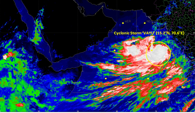
Cyclone VAYU intensifies into very severe cyclonic storm.
Home Minister, Amit Shah chaired a high level meeting in New Delhi on Tuesday to review the preparedness of State and Central Ministries/Agencies concerned to deal with the situation arising out of Cyclone ‘VAYU’.
Measures to Take During/After Cyclone (if indoors)
• Switch off electrical mains, gas supply.
• Keep doors and windows shut.
• If your house is unsafe, leave early before the onset of the cyclone.
• Listen to a radio/transistor.
• Drink boiled/chlorinated water.
• Rely only on official warnings.
WEB DESK
The India Meteorological Department said today that Cyclone Vayu is now at 280 km south-southwest of Mumbai. Winds over North Maharashtra coast are very likely to be 50-60 kmph gusting to 70 kmph.
Meanwhile, Gujarat is on alert after the severe cyclonic storm moves northwards. The India Meteorological Department (IMD) said the cyclone is likely to hit the Gujarat coast on the morning of June 13.
“It is very likely to move nearly northward and cross the Gujarat coast between Porbandar and Mahuva around Veraval and Diu region as a severe cyclonic storm with wind speed 110-120 kilometres per hour gusting to 135 kilometres per hour during early morning of June 13,” it said.
In its forecast for June 13, the IMD said, “Gale wind speed of the order of 110-120 kmph gusting to 135 kmph very likely over north Arabian Sea and Gujarat coast in morning hours and decrease gradually thereafter. It is very likely to be 50-60 kmph gusting to 70 kmph over north Maharashtra coasts and northern parts of east central Arabian Sea.”

The IMD has issued a warning of heavy rains and high winds at a speed of over 110 kilometres per hour on June 13 and 14 in the coastal areas of Saurashtra and Kutch.
The Gujarat government is on high alert. It deployed National Disaster Response Force (NDRF) personnel in the coastal areas of Saurashtra and Kutch Tuesday morning. It has advised fishermen against venturing into the sea in the next few days, while ports have been directed to flag a danger signal.
“Storm surge of height of about 1-1.5 metres above the astronomical tides likely to inundate the low-lying coastal areas of Kutch, Devbhoomi Dwarka, Porbandar, Junagarh, Diu, Gir Somnath, Amreli and Bhavnagar districts at the time of landfall,” the weather office said in the bulletin.
Last month, ‘very severe cyclonic storm’ ‘Fani’ had battered Odisha and killed over 60 people.