
KOLKATA: A scorched Kolkata was lashed by a thunderstorm and rain on Sunday afternoon that pulled the mercury down by six degrees. The relief came after a long, searing spell of heat during which the maximum temperature remained around 36-37 degrees with just two thunderstorms in May that failed to keep the rising mercury in check. And the good news from the Met office is that the maximum temperature will not climb above 33 degrees over the next 48 hours during which more showers could lash the city. Kolkata recorded a maximum temperature of 34.8 degrees on Sunday.
The pre-monsoon relief had been predicted after a north-south low-pressure trough developed between Jharkhand and northeast India last week. A thunderstorm finally struck after a scorching morning that saw the maximum temperature soar past 32 degrees by 11.30am. It was fuelled by wind at 54 km/hour, but Sunday’s storm didn’t qualify as a squall since it lasted less than a minute. While Kolkata received light rain, the neighbouring districts of Howrah, South 24 Parganas and East Midnapore were lashed by heavier showers and more severe thunderstorms.
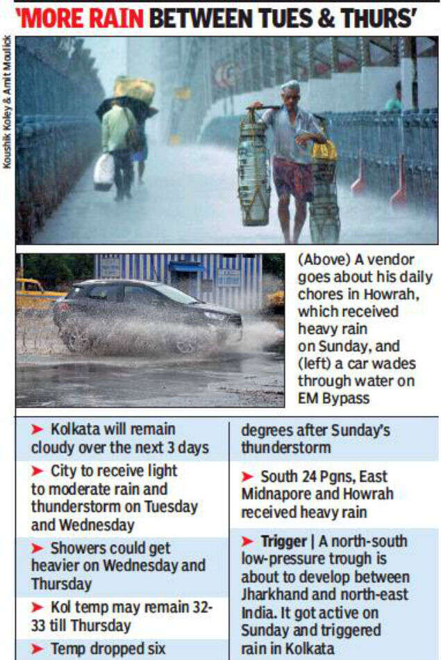
“The trough will remain active through the week and could move south, closer to south Bengal. We expect sporadic showers in Kolkata on Monday and Tuesday while the rain could get heavier on Wednesday and Thursday,” said Regional Meteorological Centre (RMC) director G K Das. The coastal districts could receive heavy showers and the maximum temperature may not cross 33 degrees.
Till the low-pressure trough-generated clouds reached Kolkata at around 12.45pm, it remained extremely uncomfortable with the mercury reaching 34.4 degrees as early as 11.30 in the morning. After the thunderstorm struck, the mercury plunged to 28.4 degrees at 2.30pm. “The temperature drop was sharp and we don’t expect the day temperature to cross 35 degrees till at least Thursday,” said Das.
But Sunday’s thunderstorm was not the result of ‘pre-monsoon’ activity, added Das. “If the showers continue and get heavier, then they may be termed pre-monsoon. But it’s June and we are approaching the onset of monsoon so heavy and frequent showers may eventually merge with monsoon rain,” said a weather scientist.
The RMC, however, has not yet made any prediction on the onset of monsoon in south Bengal and Kolkata. “It’s been delayed in Kerala but it’s difficult to say how long it could take to reach Kolkata once it reaches the southern state. While Kerala gets its monsoon currents from the Arabian Sea, Bengal gets its currents from the Bay of Bengal. Often, the currents get stalled after reaching Kerala and monsoon rain disappears in Bengal. This is what had happened last year,” said Das.
There were just two squalls last month which is less than the number of squalls in May, 2018. Cyclone Fani triggered rain on May 3 and 4, but the impact of the showers ebbed with the passing away of the cyclone. “In fact, Fani had sucked out all the moisture from the region, making the conditions unconducive for thunderstorms. It took almost a week for a moisture-triggering high-pressure zone above Bay of Bengal — that had been wiped out by Fani — to revive and start producing moisture again,” said Das.
The pre-monsoon relief had been predicted after a north-south low-pressure trough developed between Jharkhand and northeast India last week. A thunderstorm finally struck after a scorching morning that saw the maximum temperature soar past 32 degrees by 11.30am. It was fuelled by wind at 54 km/hour, but Sunday’s storm didn’t qualify as a squall since it lasted less than a minute. While Kolkata received light rain, the neighbouring districts of Howrah, South 24 Parganas and East Midnapore were lashed by heavier showers and more severe thunderstorms.
“The trough will remain active through the week and could move south, closer to south Bengal. We expect sporadic showers in Kolkata on Monday and Tuesday while the rain could get heavier on Wednesday and Thursday,” said Regional Meteorological Centre (RMC) director G K Das. The coastal districts could receive heavy showers and the maximum temperature may not cross 33 degrees.
Till the low-pressure trough-generated clouds reached Kolkata at around 12.45pm, it remained extremely uncomfortable with the mercury reaching 34.4 degrees as early as 11.30 in the morning. After the thunderstorm struck, the mercury plunged to 28.4 degrees at 2.30pm. “The temperature drop was sharp and we don’t expect the day temperature to cross 35 degrees till at least Thursday,” said Das.
But Sunday’s thunderstorm was not the result of ‘pre-monsoon’ activity, added Das. “If the showers continue and get heavier, then they may be termed pre-monsoon. But it’s June and we are approaching the onset of monsoon so heavy and frequent showers may eventually merge with monsoon rain,” said a weather scientist.
The RMC, however, has not yet made any prediction on the onset of monsoon in south Bengal and Kolkata. “It’s been delayed in Kerala but it’s difficult to say how long it could take to reach Kolkata once it reaches the southern state. While Kerala gets its monsoon currents from the Arabian Sea, Bengal gets its currents from the Bay of Bengal. Often, the currents get stalled after reaching Kerala and monsoon rain disappears in Bengal. This is what had happened last year,” said Das.
There were just two squalls last month which is less than the number of squalls in May, 2018. Cyclone Fani triggered rain on May 3 and 4, but the impact of the showers ebbed with the passing away of the cyclone. “In fact, Fani had sucked out all the moisture from the region, making the conditions unconducive for thunderstorms. It took almost a week for a moisture-triggering high-pressure zone above Bay of Bengal — that had been wiped out by Fani — to revive and start producing moisture again,” said Das.
Elections 2019
Trending Topics
LATEST VIDEOS


City
 Delhi: AAP govt planning to make travelling in buses, Metro free for women
  Heatwave conditions peak across India, 2 dead as temperature crosses 50 in Rajasthan’s Churu
  Kalburgi murder case: Belagavi man arrested, remanded in police custody till June 7
  No fuel to two-wheeler riders sans helmet in Noida and Greater Noida
More from TOI


Navbharat Times
Featured Today in Travel
Quick Links
Lok Sabha Election Schedule 2019Lok Sabha Election NewsDelhi Capitals teamMI team 2019Rajasthan Royals 2019RCB team 2019Maharashtra Lok Sabha ConstituenciesBJP Candidate ListBJP List 2019 TamilnaduShiv Sena List 2019AP BJP List 2019Mamata BanerjeeBJP List 2019 MaharashtraPriyanka GandhiBJP List 2019 KarnatakaAMMK Candidate List 2019BJP List 2019 WBLok Sabha Elections in Tamil NaduBSP List 2019 UPNews in TamilLok Sabha Poll 2019Satta Matka 2018PM ModiMahagathbandhanNagpur BJP Candidate ListChandrababu NaiduTamil Nadu ElectionsUrmila MatondkarNews in TeluguMadras High CourtTejashwi YadavArvind KejriwalTejasvi SuryaPawan KalyanArvind KejriwalYogi AdityanathJaya PradaSatta King 2019Srinagar encounter
Get the app