
KOLKATA: It has been a scorching May with the mercury staying above the 35°C mark on 26 days, making it considerably hotter than the corresponding month in 2018.
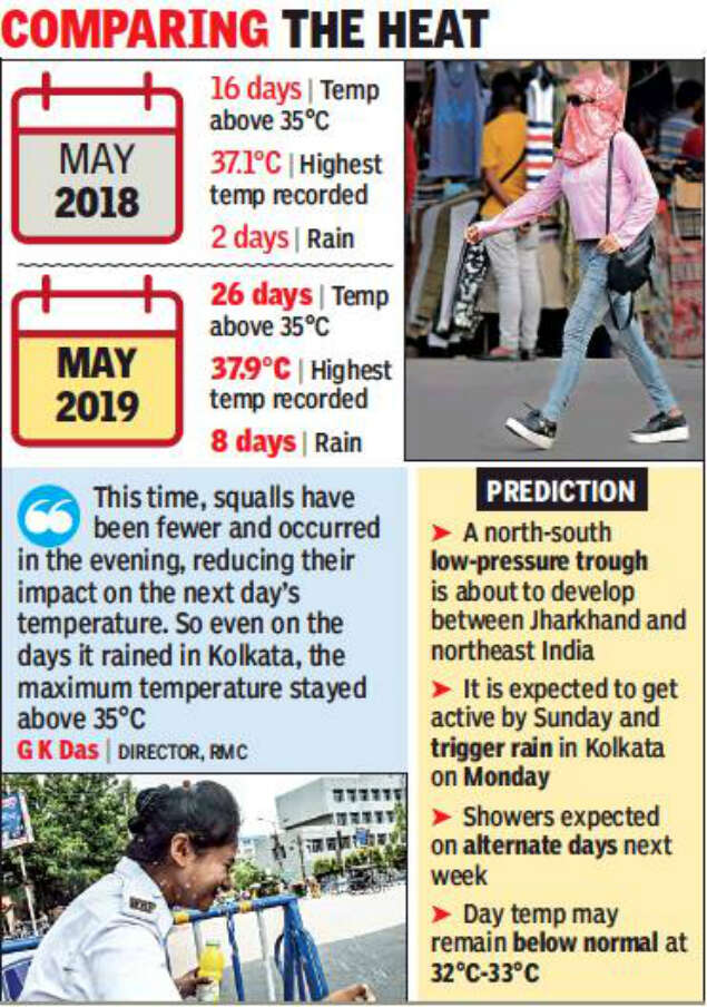
The maximum temperature touched 35°C on just 16 days last May because of frequent thunderstorms. But even though the city had more days with rain this May, the showers were lighter and failed to prevent the blistering northwesterly winds from flowing in unobstructed ever since cyclone Fani passed by. But according to the Met office, relief is just around the corner. Kolkata is set to receive showers early next week.
It’s normal for the maximum temperature to cross 35°C in May and only thunderstorms can pull the mercury down, said Regional Meteorological Centre (RMC) director G K Das.
“But this time, squalls have been fewer and occurred in the evening, reducing their impact on the next day’s temperature. So even on the days it rained in Kolkata, the maximum temperature stayed above 35°C. Heat-wave like conditions prevailed across north India, which generated scorching winds that have been flowing into Gangetic Bengal and pushing the mercury up,” he added.
There have been just two squalls last month, which is less than the number of squalls in May 2018. Cyclone Fani triggered rain on May 3 and 4, but the impact of the showers ebbed with the cyclone passing by.
“In fact, Fani had sucked out all the moisture from the region, making the conditions unfavourable for thunderstorms. It took almost a week for a moisture-triggering high-pressure zone above Bay of Bengal to revive and start producing moisture again. But the resultant dry period saw the mercury shooting up,” Das explained.
The highest temperature recorded in Kolkata this season was 37.9°C in May. Last May, the highest recorded temperature had been 37.1°C.
However, a north-south low-pressure trough about to develop between Jharkhand and northeast India is expected to get active by Sunday and trigger rain in the city on Monday. The maximum temperature is expected to plunge to 32°C-33°C and could stay at that mark for the greater part of next week, said weathermen. “There could be showers on alternate days from Monday. So, by the time the impact of the first shower wanes, we could have another spell that could again pull the mercury down. The day temperature will remain below normal next week,” said Das.
The Met office also predicted that the worst part of summer could be over in Kolkata and Gangetic Bengal. Pre-monsoon showers that begin next week may continue in sporadic spells till monsoon arrives. There was, however, no definite prediction about the arrival of monsoon in south Bengal. “It has been delayed in Kerala, but it is difficult to say how long it could take to reach Kolkata once it reaches the southern state. While Kerala gets its monsoon currents from the Arabian Sea, Bengal gets its currents from the Bay of Bengal. Often, the currents get stalled after reaching Kerala and monsoon rain disappears in Bengal. This is what happened last year,” said Das.
Elections 2019
Trending Topics
LATEST VIDEOS


More from TOI


Navbharat Times
Featured Today in Travel
Quick Links
Lok Sabha Election Schedule 2019Lok Sabha Election NewsDelhi Capitals teamMI team 2019Rajasthan Royals 2019RCB team 2019Maharashtra Lok Sabha ConstituenciesBJP Candidate ListBJP List 2019 TamilnaduShiv Sena List 2019AP BJP List 2019Mamata BanerjeeBJP List 2019 MaharashtraPriyanka GandhiBJP List 2019 KarnatakaAMMK Candidate List 2019BJP List 2019 WBLok Sabha Elections in Tamil NaduBSP List 2019 UPNews in TamilLok Sabha Poll 2019Satta Matka 2018PM ModiMahagathbandhanNagpur BJP Candidate ListChandrababu NaiduTamil Nadu ElectionsUrmila MatondkarNews in TeluguMadras High CourtTejashwi YadavArvind KejriwalTejasvi SuryaPawan KalyanArvind KejriwalYogi AdityanathJaya PradaSatta King 2019Srinagar encounter
Get the app