")
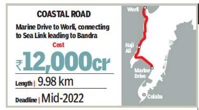
Nearly 68,000 cars are expected to take the Coastal Road one way when it is commissioned in early 2023, according to top civic officials. While currently it takes nearly two hours—even more on certain days—to reach south Mumbai from the suburbs, commute time will decrease to about 40 minutes on the new corridor.
However, former Mumbai Metropolitan Region Development Authority (MMRDA) planner Kedar Ghorpade said all new projects_metro, Coastal Road, the flyovers, bullet train_ are aimed at boosting travel along the north-south axis while forecasts project growth on the east-west axis. “The urban growth of MMR is toward Pune, Solapur, Kolhapur which makes east-west connections more important,” he said.
Transport activist A V Shenoy said there was no doubt that the Coastal Road would take the pressure off the Pedder Road alignment, but one had to bear in mind that the underground Metro line too would be commissioned around the same time. “It has to be looked at holistically, whether the car population will shift to the Coastal Road or would many prefer the Metro which, according to estimates, will carry 14 lakh passengers daily,” he said.
Shenoy said the Coastal Road would have a dedicated lane for buses, but they do not ply on the Sea Link.
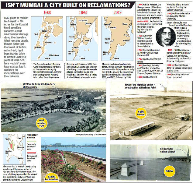
It’s widely believed that the Coastal Road idea dates back to the landmark 1962 transport study by Wilbur Smith Associates. That report talked of a West Island and East Island Freeway running along both sides of the island city. But the freeway referred to in that study is nothing like the Coastal Road of today, says V. Phatak, former chief planner of MMRDA. “What was called the west island, east island, and central freeways referred to three major arteries. On the west, that meant Marine Drive, Annie Besant Road etc.”
A comprehensive transport study of 2008 also did not mention a Coastal Road. The focus of that study was not private transit. “Improving public transport was the focus,” said Phatak. He believes the first mention of the road came in McKinsey’s 2003 Vision Mumbai document. Phatak, who oversaw city development plans, said a Coastal Road of the type being constructed today was never considered because of the coastal regulation zone (CRZ) rules, which bars reclamation. It was former CM Prithiviraj Chavan who brought up the Coastal Road idea in 2011. A committee headed by then civic chief Subodh Kumar was formed to look into feasibility. Green clearances were granted in 2017. On the present controversy, Phatak said a key issue is that business is declining in Fort and Nariman Pt. “Whether the road makes sense is a matter of debate.”
(With inputs from Vaishnavi Chandrashekhar)

One of the project’s objectives is to take the load off the stretch from Babulnath temple to Hughes Road and Pedder Road going up to Worli. “Currently traffic from the north towards South Mumbai is stuck in jams. At least half of those on the Bandra Worli Sea Link proceed to south Mumbai,” said officials, suggesting that these would be redistributed between Coastal Road and Pedder Road. The Sea Link was built to cater to one lakh cars per day; currently around 40,000 cars use this route daily.
However, former Mumbai Metropolitan Region Development Authority (MMRDA) planner Kedar Ghorpade said all new projects_metro, Coastal Road, the flyovers, bullet train_ are aimed at boosting travel along the north-south axis while forecasts project growth on the east-west axis. “The urban growth of MMR is toward Pune, Solapur, Kolhapur which makes east-west connections more important,” he said.
Transport activist A V Shenoy said there was no doubt that the Coastal Road would take the pressure off the Pedder Road alignment, but one had to bear in mind that the underground Metro line too would be commissioned around the same time. “It has to be looked at holistically, whether the car population will shift to the Coastal Road or would many prefer the Metro which, according to estimates, will carry 14 lakh passengers daily,” he said.
Shenoy said the Coastal Road would have a dedicated lane for buses, but they do not ply on the Sea Link.
It’s widely believed that the Coastal Road idea dates back to the landmark 1962 transport study by Wilbur Smith Associates. That report talked of a West Island and East Island Freeway running along both sides of the island city. But the freeway referred to in that study is nothing like the Coastal Road of today, says V. Phatak, former chief planner of MMRDA. “What was called the west island, east island, and central freeways referred to three major arteries. On the west, that meant Marine Drive, Annie Besant Road etc.”
A comprehensive transport study of 2008 also did not mention a Coastal Road. The focus of that study was not private transit. “Improving public transport was the focus,” said Phatak. He believes the first mention of the road came in McKinsey’s 2003 Vision Mumbai document. Phatak, who oversaw city development plans, said a Coastal Road of the type being constructed today was never considered because of the coastal regulation zone (CRZ) rules, which bars reclamation. It was former CM Prithiviraj Chavan who brought up the Coastal Road idea in 2011. A committee headed by then civic chief Subodh Kumar was formed to look into feasibility. Green clearances were granted in 2017. On the present controversy, Phatak said a key issue is that business is declining in Fort and Nariman Pt. “Whether the road makes sense is a matter of debate.”
(With inputs from Vaishnavi Chandrashekhar)
#ElectionsWithTimes
more from times of india cities
Elections 2019

Trending Topics
LATEST VIDEOS
City
 Nagpur: Water crisis for Wadi residents, water tanker sent to locality after 15 days
  Navi Mumbai: Unique artwork on master blaster Sachin Tendulkar’s 46th birthday at Seawoods Grand Central Mall
  Delhi: Gautam Gambhir addresses party workers during introductory meet
  Lok Sabha elections 2019: BJP fields singer Hans Raj Hans from North-West Delhi
More from TOI


Navbharat Times
Featured Today in Travel
Quick Links
Lok Sabha Election Schedule 2019Lok Sabha Election NewsDelhi Capitals teamMI team 2019Rajasthan Royals 2019RCB team 2019Maharashtra Lok Sabha ConstituenciesBJP Candidate ListBJP List 2019 TamilnaduShiv Sena List 2019AP BJP List 2019Mamata BanerjeeBJP List 2019 MaharashtraPriyanka GandhiBJP List 2019 KarnatakaAMMK Candidate List 2019BJP List 2019 WBLok Sabha Elections in Tamil NaduBSP List 2019 UPNews in TamilLok Sabha Poll 2019Satta Matka 2018PM ModiMahagathbandhanNagpur BJP Candidate ListChandrababu NaiduTamil Nadu ElectionsUrmila MatondkarNews in TeluguMadras High CourtTejashwi YadavArvind KejriwalTejasvi SuryaPawan KalyanArvind KejriwalYogi AdityanathJaya PradaSatta King 2019Srinagar encounter
Get the app