
Pune: Warmer nights fail to ward off daytime chill
Neha Madaan | TNN | Updated: Dec 16, 2018, 11:35 IST On Friday, the day temperature in Pune city had plunged to 26.7°C, which is this season’s lowest.
PUNE: Even though the night temperatures have climbed back to double digits in the city, there has been a lingering chill in the air — primarily due to a drop in day temperatures and wind flow.
On Friday, the day temperature in Pune city had plunged to 26.7°C, which is this season’s lowest.
Mahabaleshwar, Buldhana and Satara were among the other cities in the state with the lowest day temperature on Friday.
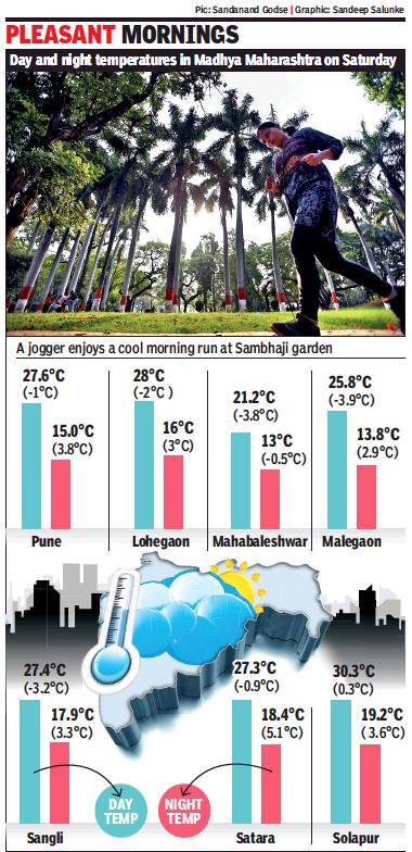
Though the day temperature increased by a degree at Shivajinagar (27.6°C) on Saturday, it still was below normal for this time of the year.
Saturday was the city’s second coldest day this season. The day temperature in Lohegaon touched 28°C on Saturday, which is 2°C below normal. Incidentally, both Friday and Saturday started off with higher than normal minimum temperatures of 12.4°C and 15°C respectively.
The drop in day temperatures and the wind flow are responsible for this chill factor, said the officials of the India Meteorological Department (IMD).
“The marginal dip in the day temperature has been caused by the partially cloudy skies, which managed to restrict Pune’s quota of daily sunshine over the last couple of days,” said Anupam Kashyapi, the head of weather, IMD, Pune.
Kashyapi said places in southern Maharashtra and Pune are experiencing 15%-20% cloud cover — which is generally referred to as “mainly clear skies” in IMD terminology.
“Such type of clouding does not result in rainfall, but it has certainly caused a marginal dip in maximum temperatures and a rise in minimum temperatures. The cloudiness is a result of a cyclonic storm called ‘Phethai’ over the Bay of Bengal. This system may also cause partial cloudiness in southern parts of the state,” Kashyapi said.
“Right now, there is partial moisture incursion over the Konkan and Goa regions, which may result in isolated light rainfall over the next two days in that region,” he added.
According to India Meteorological Department officials on Saturday, the cyclonic storm is likely to intensify into a severe cyclonic storm in the next 24 hours.
“The system is likely to make a landfall on December 17, so the current weather situation in Maharashtra may sustain for a couple of days,” Kashyapi added.
On why it still feels cold despite a rise in night temperature, Kashyapi said when the fall in day temperature is accompanied by wind flow, it tends to bring a chill factor.
“Usually, winter experiences northerly wind flow. These are the cold winds coming in from the North. Instances of northerly wind flow this season were relatively less, except when the mercury had dipped below 10°C in Pune a few days ago. Currently, we do not have a northerly wind flow in the city, but still, some wind activity is there. It is accompanied by a drop in maximum temperature,” he said.
On Friday, the day temperature in Pune city had plunged to 26.7°C, which is this season’s lowest.
Mahabaleshwar, Buldhana and Satara were among the other cities in the state with the lowest day temperature on Friday.
Though the day temperature increased by a degree at Shivajinagar (27.6°C) on Saturday, it still was below normal for this time of the year.
Saturday was the city’s second coldest day this season. The day temperature in Lohegaon touched 28°C on Saturday, which is 2°C below normal. Incidentally, both Friday and Saturday started off with higher than normal minimum temperatures of 12.4°C and 15°C respectively.
The drop in day temperatures and the wind flow are responsible for this chill factor, said the officials of the India Meteorological Department (IMD).
“The marginal dip in the day temperature has been caused by the partially cloudy skies, which managed to restrict Pune’s quota of daily sunshine over the last couple of days,” said Anupam Kashyapi, the head of weather, IMD, Pune.
Kashyapi said places in southern Maharashtra and Pune are experiencing 15%-20% cloud cover — which is generally referred to as “mainly clear skies” in IMD terminology.
“Such type of clouding does not result in rainfall, but it has certainly caused a marginal dip in maximum temperatures and a rise in minimum temperatures. The cloudiness is a result of a cyclonic storm called ‘Phethai’ over the Bay of Bengal. This system may also cause partial cloudiness in southern parts of the state,” Kashyapi said.
“Right now, there is partial moisture incursion over the Konkan and Goa regions, which may result in isolated light rainfall over the next two days in that region,” he added.
According to India Meteorological Department officials on Saturday, the cyclonic storm is likely to intensify into a severe cyclonic storm in the next 24 hours.
“The system is likely to make a landfall on December 17, so the current weather situation in Maharashtra may sustain for a couple of days,” Kashyapi added.
On why it still feels cold despite a rise in night temperature, Kashyapi said when the fall in day temperature is accompanied by wind flow, it tends to bring a chill factor.
“Usually, winter experiences northerly wind flow. These are the cold winds coming in from the North. Instances of northerly wind flow this season were relatively less, except when the mercury had dipped below 10°C in Pune a few days ago. Currently, we do not have a northerly wind flow in the city, but still, some wind activity is there. It is accompanied by a drop in maximum temperature,” he said.
FROM AROUND THE WEB


more from times of india Cities
LATEST VIDEOS


City
 On cam: Man steals diamond jewellery worth Rs 6 lakh from exhibition in Surat01:51
- UP police arrest 2 criminals after late night encounter in Noida01:17
- Medical student dies in tug-of-war game00:52
- On cam: Cop thrashes man without helmet, suspended00:38
- Row erupts over separate mess entry for veg, non-veg students at IIT-Madras02:42
- Delhi govt mulls restrictions on lavish weddings01:37
- Bengaluru’s annual cake show: Edible Christmas snowman, Red Fort on display01:05
- Nursery admission process in Delhi starts today01:04
- Rajasthan: 3 supporters of Sachin Pilot climb atop water tank, demand Sachin be made the CM01:05
- Unique! Blindfolded, Pune techie couple gets married at ashram for visually impaired elderly women00:59


All Comments ()+^ Back to Top
Refrain from posting comments that are obscene, defamatory or inflammatory, and do not indulge in personal attacks, name calling or inciting hatred against any community. Help us delete comments that do not follow these guidelines by marking them offensive. Let's work together to keep the conversation civil.
HIDE