
Depression over Bay of Bengal may turn into cyclone
TNN | Updated: Nov 11, 2018, 08:08 IST Representative image
CHENNAI: A cyclone likely to form over the Bay of Bengal may bring heavy rain to the city by the middle of next week as the Met office has forecast that the system is expected to move towards north Tamil Nadu. However, independent weather experts said the system may weaken by the time the cyclone makes landfall.
According to IMD’s regional weather inference, the well-marked low pressure area over southeast Bay of Bengal and adjoining north Andaman has intensified into a depression. This weather system that lay centred about 20km northwest of Port Blair and about 1340km east-southeast of Chennai is very likely to intensify into a deep depression during the next 24 hours and into a cyclonic storm in the subsequent 24 hours.
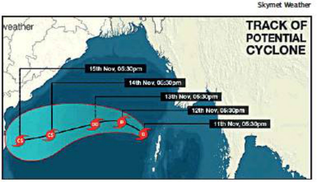
The system is very likely to move west-north-westwards during the next 48 hours and then west-south-westwards towards north Tamil Nadu-south Andhra Pradesh coast in the subsequent 72 hours. The system may bring heavy rainfall to coastal districts of Tamil Nadu including Chennai and Andhra Pradesh around November 14 and 15, weathermen said.
IMD has issued a warning for heavy rainfall on November 14 at isolated places over coastal Tamil Nadu and Puducherry.
Skymet weather chief meteorologist Mahesh Palawat said the system may lose its intensity when it makes landfall and hence the rainfall may not be very heavy. “Models are showing changes. As of now, Chennai may get rainfall of about 60-70mm while southern suburbs may receive more,” he said. For the next 48 hours, light rain is likely to occur in some areas of the city. The sky is likely to be partly cloudy. The maximum and minimum temperatures will hover around 32 and 24 degrees Celsius respectively.
According to IMD’s regional weather inference, the well-marked low pressure area over southeast Bay of Bengal and adjoining north Andaman has intensified into a depression. This weather system that lay centred about 20km northwest of Port Blair and about 1340km east-southeast of Chennai is very likely to intensify into a deep depression during the next 24 hours and into a cyclonic storm in the subsequent 24 hours.
The system is very likely to move west-north-westwards during the next 48 hours and then west-south-westwards towards north Tamil Nadu-south Andhra Pradesh coast in the subsequent 72 hours. The system may bring heavy rainfall to coastal districts of Tamil Nadu including Chennai and Andhra Pradesh around November 14 and 15, weathermen said.
IMD has issued a warning for heavy rainfall on November 14 at isolated places over coastal Tamil Nadu and Puducherry.
Skymet weather chief meteorologist Mahesh Palawat said the system may lose its intensity when it makes landfall and hence the rainfall may not be very heavy. “Models are showing changes. As of now, Chennai may get rainfall of about 60-70mm while southern suburbs may receive more,” he said. For the next 48 hours, light rain is likely to occur in some areas of the city. The sky is likely to be partly cloudy. The maximum and minimum temperatures will hover around 32 and 24 degrees Celsius respectively.
FROM AROUND THE WEB


more from times of india Cities
LATEST VIDEOS


City
 Delhi's Signature Bridge becomes deadly selfie point01:05
- Caught on CCTV: Mob attacks house in east Delhi, destroys motorbike00:44
- Miraculous escape for guard as train starts moving while he fixes pipe under coach00:50
- Caught on cam: Girl beats up eve-teaser in Thane00:45
- Bribery case: Karnataka ex-BJP minister G Janardhana Reddy appears before crime branch03:59
- It is an insult to Lord Ram, seers in Ayodhya demand ban on sale of meat, liquor01:52
- Rape threats: Bengaluru artist slams Facebook for failing to take action02:00
- Amit Shah releases BJP manifesto for Chhattisgarh polls01:02
- Faridabad: Sacked employee shot Tata Steel senior manager dead01:30
- KMP Expressway opening date postponed again01:27


All Comments ()+^ Back to Top
Refrain from posting comments that are obscene, defamatory or inflammatory, and do not indulge in personal attacks, name calling or inciting hatred against any community. Help us delete comments that do not follow these guidelines by marking them offensive. Let's work together to keep the conversation civil.
HIDE