
Chennai gets rain ready with portal for real-time mapping of flooded areas
Shruti Suresh | TNN | Nov 1, 2018, 06:09 IST Picture used for representational purpose only
CHENNAI: The monsoon is almost here but you will no longer have to worry about planning your travel. RiskMap.in, an online platform that crowdsources information entered through social media platforms has made available first-hand information on flooded locations, real-time photos, and description of the flooding level on a live map. It can also be accessed by government agencies to monitor flood management activities.
On the portal, where a web-based map that covers every street of the city is available, users can with the hlpe of social media platforms like Twitter, Facebook and Telegram access link and submit details on the ground about the level of waterlogging, fallen trees or live wires, and also upload photographs.
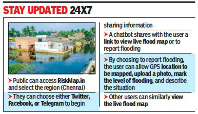
“It is a platform completely dependent on crowdsourced information. It is easy to access and there are no restrictions in terms of language. People can upload a photo of waterlogging and use markers to identify how bad the flooding is,” said Satyarupa Shekhar, director of Urban Governance Citizen consumer and civic Action Group (CAG) which is maintaining it.
Online alerts would be shared with Greater Chennai Corporation and the traffic police department through tweets so that the officials concerned are abreast of the ground reality, she added. “The inputs uploaded by residents are available on the live map for 24 hours as flood water and the rain level usually recede in as much time. With the real-time information shared among the public, they can plan upon the routes to be taken and those to be avoided,” Shekhar said.
The various government agencies accessing the live map can act upon complaints about fallen trees, traffic jams or deply adequate staff to work on pumping out water from inundated areas. “The helpline numbers have been given as well, whom the public can contact in case of extremely adverse situations,” she added.
RiskMap.in has been developed by the Urban Risk Lab at Massachusetts Institute of Technology and is deployed by CAG and 100 Resilient Cities Initiative for Chennai. As a pilot project, it was introduced in the city during the high-intensity rain in the first week of November 2017. The platform received 250 verified flood reports within a short span of 24 hours last year.
On the portal, where a web-based map that covers every street of the city is available, users can with the hlpe of social media platforms like Twitter, Facebook and Telegram access link and submit details on the ground about the level of waterlogging, fallen trees or live wires, and also upload photographs.
“It is a platform completely dependent on crowdsourced information. It is easy to access and there are no restrictions in terms of language. People can upload a photo of waterlogging and use markers to identify how bad the flooding is,” said Satyarupa Shekhar, director of Urban Governance Citizen consumer and civic Action Group (CAG) which is maintaining it.
Online alerts would be shared with Greater Chennai Corporation and the traffic police department through tweets so that the officials concerned are abreast of the ground reality, she added. “The inputs uploaded by residents are available on the live map for 24 hours as flood water and the rain level usually recede in as much time. With the real-time information shared among the public, they can plan upon the routes to be taken and those to be avoided,” Shekhar said.
The various government agencies accessing the live map can act upon complaints about fallen trees, traffic jams or deply adequate staff to work on pumping out water from inundated areas. “The helpline numbers have been given as well, whom the public can contact in case of extremely adverse situations,” she added.
RiskMap.in has been developed by the Urban Risk Lab at Massachusetts Institute of Technology and is deployed by CAG and 100 Resilient Cities Initiative for Chennai. As a pilot project, it was introduced in the city during the high-intensity rain in the first week of November 2017. The platform received 250 verified flood reports within a short span of 24 hours last year.
FROM AROUND THE WEB


more from times of india Cities
LATEST VIDEOS


City
 Kambhampati Hari Babu flagged off run for unity in Visakhapatnam01:09
- Why I stripped in the elevator: Aspiring model bares it all02:54
- PM Modi unveils Statue of Unity on the banks of the Narmada04:18
- Visakhapatnam: High drama as man climbs cell tower at collectorate01:48
- Jaipur: MLA Hanuman Beniwal launches ‘Rashtriya Loktantrik Party’ at Hunkar rally01:06
- West Bengal: Tiger cub found dead at Bengal Safari Park in Siliguri01:39
- In world's largest clay diya mosaic, Virat Kohli shines bright01:24
- Rahul Gandhi offers prayers at Ujjain's Mahakaleshwar temple02:47
- Fringe becomes censor again, Sunny Leone in the line of fire02:05
- Caught on cam: Man tries to kidnap 8-year-old in Surat, attempt foiled01:09


All Comments ()+^ Back to Top
Refrain from posting comments that are obscene, defamatory or inflammatory, and do not indulge in personal attacks, name calling or inciting hatred against any community. Help us delete comments that do not follow these guidelines by marking them offensive. Let's work together to keep the conversation civil.
HIDE