Photo: Carol Kaliff / Hearst Connecticut Media
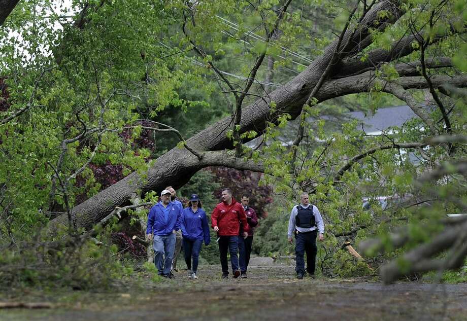
A National Weather Service team, including meteorologist Bill Goodman, far left, tours Brookfield along with State Police on Wednesday to assess damage from Tuesday's storm. The team concluded that the damage was most likely caused by a “macroburst” than a tornado.
lessA National Weather Service team, including meteorologist Bill Goodman, far left, tours Brookfield along with State Police on Wednesday to assess damage from Tuesday's storm. The team concluded that the damage
... more
Bill Goodman, left, and Carlie Buccola, right, meterologists with the National Weather Service, tour Candlewood Shores in Brookfield to assess storm damage and determine if Tuesday's weather was the result of a tornado. They are joined by State Police and media, Wednesday, May 16, 2018.
lessBill Goodman, left, and Carlie Buccola, right, meterologists with the National Weather Service, tour Candlewood Shores in Brookfield to assess storm damage and determine if Tuesday's weather was the result of
... more
Bill Goodman, left, and Carlie Buccola, meterologists with the National Weather Service, tour Candlewood Shores in Brookfield to assess storm damage and determine if Tuesday's weather was the result of a tornado. They are joined by State Police and media, Wednesday, May 16, 2018.
lessBill Goodman, left, and Carlie Buccola, meterologists with the National Weather Service, tour Candlewood Shores in Brookfield to assess storm damage and determine if Tuesday's weather was the result of a
... more
Carlie Buccola, left, and Bill Goodman, meterologists with the National Weather Service, tour Echo Bay Marina in Brookfield to assess storm damage and determine if Tuesday's weather was the result of a tornado. Wednesday, May 16, 2018.
lessCarlie Buccola, left, and Bill Goodman, meterologists with the National Weather Service, tour Echo Bay Marina in Brookfield to assess storm damage and determine if Tuesday's weather was the result of a tornado.
... more
This aerial view shows storm damage to Brookfield, Conn., on Tuesday, May 15, 2018. Residents in the Northeast cleaned up Wednesday, a day after powerful storms pounded the region with torrential rain and marble-sized hail, leaving more then 200,000 homes and businesses without power. (John Woike/Hartford Courant via AP)
lessThis aerial view shows storm damage to Brookfield, Conn., on Tuesday, May 15, 2018. Residents in the Northeast cleaned up Wednesday, a day after powerful storms pounded the region with torrential rain and
... more
A rare violent storm, described as a microburst, destroyed a living room in Brookfield on Tuesday, May 15.
A rare violent storm, described as a microburst, destroyed a living room in Brookfield on Tuesday, May 15.
Scott McNulty, Rob Kelemen and Dan Beisaw of Rob's Tree Removal survey an oak tree lying across the home of John Cratty at 49 Hillview Avenue in Hamden on May 16, 2018. Cratty's two children heeded warnings and went into the basement moments before the tree hit the house the previous afternoon.
lessScott McNulty, Rob Kelemen and Dan Beisaw of Rob's Tree Removal survey an oak tree lying across the home of John Cratty at 49 Hillview Avenue in Hamden on May 16, 2018. Cratty's two children heeded warnings
... more
Tuesday's storm caused extensive damage in New Fairfield.
Tuesday's storm caused extensive damage in New Fairfield.
Tuesday's storm caused extensive damage in New Fairfield.
Tuesday's storm caused extensive damage in New Fairfield.
Nigel Davis (center left) of New Haven and Steven Imperati (center right) of Hamden clear tree branches on Todd St. in Hamden on May 16, 2018 so two women can walk past.
Nigel Davis (center left) of New Haven and Steven Imperati (center right) of Hamden clear tree branches on Todd St. in Hamden on May 16, 2018 so two women can walk past.
Photo: Arnold Gold, Connecticut Hearst Media
Tuesday's storm caused extensive damage in New Fairfield.
Tuesday's storm caused extensive damage in New Fairfield.
Arborists remove a large tree from the roof of an 18th century home at 62 Main Street in Newtown, Conn. on Wednesday, May 16, 2018 in the aftermath of Tuesday evening's storm. Homeowner Betsy Kenyon arrived home from work to discover the damage.
lessArborists remove a large tree from the roof of an 18th century home at 62 Main Street in Newtown, Conn. on Wednesday, May 16, 2018 in the aftermath of Tuesday evening's storm. Homeowner Betsy Kenyon arrived
... more
Downed trees and power lines block Main Street South in Bridgewater, Conn., after severe storms rolled through the area Tuesday, May 15, 2018.Residents in the Northeast cleaned up Wednesday, a day after powerful storms pounded the region with torrential rain and marble-sized hail, leaving more 200,000 homes and businesses without power. (John Woike/Hartford Courant via AP)
lessDowned trees and power lines block Main Street South in Bridgewater, Conn., after severe storms rolled through the area Tuesday, May 15, 2018.Residents in the Northeast cleaned up Wednesday, a day after
... more
Tuesday's storm caused extensive damage in New Fairfield.
Tuesday's storm caused extensive damage in New Fairfield.
A pine tree rests on the Jonathan Dickerman House Museum on Mt. Carmel Ave. in Hamden on May 16, 2018.
A pine tree rests on the Jonathan Dickerman House Museum on Mt. Carmel Ave. in Hamden on May 16, 2018.
Photo: Arnold Gold, Connecticut Hearst Media
A pine tree rests on the Jonathan Dickerman House Museum on Mt. Carmel Ave. in Hamden on May 16, 2018.
A pine tree rests on the Jonathan Dickerman House Museum on Mt. Carmel Ave. in Hamden on May 16, 2018.
Photo: Arnold Gold, Connecticut Hearst Media
Chris Fletcher,left, and his wife Noel survey the storm damage to their home in Cheshire with a Cheshire volunteer firefighter on Wednesday, May 16, 2018. Residents in the Northeast cleaned up Wednesday, a day after powerful storms pounded the region with torrential rain and marble-sized hail, leaving more then 200,000 homes and businesses without power. (Patrick Raycraft/Hartford Courant via AP)
lessChris Fletcher,left, and his wife Noel survey the storm damage to their home in Cheshire with a Cheshire volunteer firefighter on Wednesday, May 16, 2018. Residents in the Northeast cleaned up Wednesday, a day
... more
Noah Seltzer (left) and Sabrina Ruiz of Hamden survey the a grove of pine trees near the entrance to Sleeping Giant State Park on Mt. Carmel Ave. in Hamden on May 16, 2018 that were destroyed during the previous night's storm. The two had been caught descending a trail at the park when the storm hit.
lessNoah Seltzer (left) and Sabrina Ruiz of Hamden survey the a grove of pine trees near the entrance to Sleeping Giant State Park on Mt. Carmel Ave. in Hamden on May 16, 2018 that were destroyed during the
... more
Tuesday's storm caused extensive damage in New Fairfield.
Tuesday's storm caused extensive damage in New Fairfield.
Two women look at the storm damage in Bridgewater, Conn., Tuesday, May 15, 2018. after severe storms rolled through the area. Residents in the Northeast cleaned up Wednesday, a day after powerful storms pounded the region with torrential rain and marble-sized hail, leaving more then 200,000 homes and businesses without power. (John Woike/Hartford Courant via AP)
lessTwo women look at the storm damage in Bridgewater, Conn., Tuesday, May 15, 2018. after severe storms rolled through the area. Residents in the Northeast cleaned up Wednesday, a day after powerful storms
... more
Storm damage on Todd Street in Hamden on May 16, 2018.
Storm damage on Todd Street in Hamden on May 16, 2018.
Photo: Arnold Gold, Connecticut Hearst Media
A car is buried under trees limbs and powerlines in Brookfield Wednesday, May 16, 2018.
A car is buried under trees limbs and powerlines in Brookfield Wednesday, May 16, 2018.
Photo: Carol Kaliff, Hearst Connecticut Media
Arborists remove a large tree from the roof of an 18th century home at 62 Main Street in Newtown, Conn. on Wednesday, May 16, 2018 in the aftermath of Tuesday evening's storm. Homeowner Betsy Kenyon arrived home from work to discover the damage.
lessArborists remove a large tree from the roof of an 18th century home at 62 Main Street in Newtown, Conn. on Wednesday, May 16, 2018 in the aftermath of Tuesday evening's storm. Homeowner Betsy Kenyon arrived
... more
Nancy Faroux-Stowe clears storm debris from in front of her home as a payloader clears a tree from the roadway on Route 25 in Monroe, Conn. on Wednesday, May 16, 2018 in the aftermath of Tuesday evening's storm.
lessNancy Faroux-Stowe clears storm debris from in front of her home as a payloader clears a tree from the roadway on Route 25 in Monroe, Conn. on Wednesday, May 16, 2018 in the aftermath of Tuesday evening's
... more
Keith W. Confalone, right, is helping to cut down branches from a roof on Skyline Drive in Brookfield where he is clearing fallen tree branches, Wednesday, may 16, 2018.
Keith W. Confalone, right, is helping to cut down branches from a roof on Skyline Drive in Brookfield where he is clearing fallen tree branches, Wednesday, may 16, 2018.
Photo: Carol Kaliff, Hearst Connecticut Media
Chris Stunkel picks up fallen branches and debris from his yard on Clearview Drive in Brookfield Wednesday, May 16, 2018, the result of Tuesday's storm.
Chris Stunkel picks up fallen branches and debris from his yard on Clearview Drive in Brookfield Wednesday, May 16, 2018, the result of Tuesday's storm.
Photo: Carol Kaliff, Hearst Connecticut Media
Tuesday's storm caused extensive damage in New Fairfield.
Tuesday's storm caused extensive damage in New Fairfield.
Keith W. Confalone is standing on a roof of a home on Skyline Drive in Brookfield where he is clearing fallen tree branches, Wednesday, May 16, 2018. The house has a gaping hole on the right.
Keith W. Confalone is standing on a roof of a home on Skyline Drive in Brookfield where he is clearing fallen tree branches, Wednesday, May 16, 2018. The house has a gaping hole on the right.
Photo: Carol Kaliff, Hearst Connecticut Media
Keith W. Confalone is standing on a roof of a home on Skyline Drive in Brookfield where he is clearing fallen tree branches, Wednesday, may 16, 2018.
Keith W. Confalone is standing on a roof of a home on Skyline Drive in Brookfield where he is clearing fallen tree branches, Wednesday, may 16, 2018.
Photo: Carol Kaliff, Hearst Connecticut Media
Damage from Tuesday's storm was extensive in Candlewood Shores in Brookfield. Photo Wednesday, may 16, 2018.
Damage from Tuesday's storm was extensive in Candlewood Shores in Brookfield. Photo Wednesday, may 16, 2018.
Photo: Carol Kaliff, Hearst Connecticut Media
A huge tree crashing onto to the roof of Debbie Marks home on Elbow Hill in Brookfield, caused extensive damage to parts of the inside of the house including the master bedroom,Wednesday, May 16, 2018.
A huge tree crashing onto to the roof of Debbie Marks home on Elbow Hill in Brookfield, caused extensive damage to parts of the inside of the house including the master bedroom,Wednesday, May 16, 2018.
Photo: Carol Kaliff, Hearst Connecticut Media
Shawn Brady of J & S Contracting in New Milford, cuts tree limbs off of a house on Elbow Hill in Brookfield Wednesday, May 16, 2018, a result of Tuesday's storm.
Shawn Brady of J & S Contracting in New Milford, cuts tree limbs off of a house on Elbow Hill in Brookfield Wednesday, May 16, 2018, a result of Tuesday's storm.
Photo: Carol Kaliff, Hearst Connecticut Media
Sue Sullivan and Will Oster bring ice to a friend on Candlewood Shores in Brookfield who lost power in tuesday's storm so that the food in her refrigerator won't spoil, Wednesday, may 16, 2018.
Sue Sullivan and Will Oster bring ice to a friend on Candlewood Shores in Brookfield who lost power in tuesday's storm so that the food in her refrigerator won't spoil, Wednesday, may 16, 2018.
Photo: Carol Kaliff, Hearst Connecticut Media
Gov. Dannel Malloy addresses the media during a press conference at the Brookfield Police Station regarding Tuesday's storm. First Selectman Steve Dunn also spoke. Wed. May 16, 2018.
Gov. Dannel Malloy addresses the media during a press conference at the Brookfield Police Station regarding Tuesday's storm. First Selectman Steve Dunn also spoke. Wed. May 16, 2018.
Photo: Carol Kaliff, Hearst Connecticut Media
Tuesday's storm caused extensive damage in New Fairfield.
Tuesday's storm caused extensive damage in New Fairfield.
Much damaged was visible on Skyline Drive at Candlewood Shores in Brookfield, Conn. after a line of powerful thunderstorms tore through the state Tuesday evening. The National Weather Service was also in town to access storm damage on Wednesday, May 16, 2018.
lessMuch damaged was visible on Skyline Drive at Candlewood Shores in Brookfield, Conn. after a line of powerful thunderstorms tore through the state Tuesday evening. The National Weather Service was also in town
... more
Storm damage on Todd Street in Hamden on May 16, 2018.
Storm damage on Todd Street in Hamden on May 16, 2018.
Photo: Arnold Gold, Connecticut Hearst Media
Storm damage on Todd Street in Hamden on May 16, 2018.
Storm damage on Todd Street in Hamden on May 16, 2018.
Photo: Arnold Gold, Connecticut Hearst Media
Storm damage on Todd Street in Hamden on May 16, 2018.
Storm damage on Todd Street in Hamden on May 16, 2018.
Photo: Arnold Gold, Connecticut Hearst Media
Storm damage at Quinnipiac University in Hamden on May 16, 2018.
Storm damage at Quinnipiac University in Hamden on May 16, 2018.
Photo: Arnold Gold, Connecticut Hearst Media
Storm damage at Quinnipiac University in Hamden on May 16, 2018.
Storm damage at Quinnipiac University in Hamden on May 16, 2018.
Photo: Arnold Gold, Connecticut Hearst Media
Storm damage at Quinnipiac University in Hamden on May 16, 2018.
Storm damage at Quinnipiac University in Hamden on May 16, 2018.
Photo: Arnold Gold, Connecticut Hearst Media
Storm damage at Quinnipiac University in Hamden on May 16, 2018.
Storm damage at Quinnipiac University in Hamden on May 16, 2018.
Photo: Arnold Gold, Connecticut Hearst Media
Tuesday's storm caused extensive damage in New Fairfield.
Tuesday's storm caused extensive damage in New Fairfield.
Storm damage at Quinnipiac University in Hamden on May 16, 2018.
Storm damage at Quinnipiac University in Hamden on May 16, 2018.
Photo: Arnold Gold, Connecticut Hearst Media
Storm damage at Quinnipiac University in Hamden on May 16, 2018.
Storm damage at Quinnipiac University in Hamden on May 16, 2018.
Photo: Arnold Gold, Connecticut Hearst Media
Storm damage at Sleeping Giant State Park in Hamden on May 16, 2018.
Storm damage at Sleeping Giant State Park in Hamden on May 16, 2018.
Photo: Arnold Gold, Connecticut Hearst Media
A pine tree rests on the Jonathan Dickerman House Museum on Mt. Carmel Ave. in Hamden on May 16, 2018.
A pine tree rests on the Jonathan Dickerman House Museum on Mt. Carmel Ave. in Hamden on May 16, 2018.
Photo: Arnold Gold, Connecticut Hearst Media
A grove of pine trees near the entrance to Sleeping Giant State Park on Mt. Carmel Ave. in Hamden photographed on May 16, 2018 were destroyed during the previous night's storm.
A grove of pine trees near the entrance to Sleeping Giant State Park on Mt. Carmel Ave. in Hamden photographed on May 16, 2018 were destroyed during the previous night's storm.
Photo: Arnold Gold, Connecticut Hearst Media
Fred Marcantonio of Oxford takes a chainsaw to downed trees on Todd St. in Hamden on May 16, 2018 near where his wife's car got stuck during the previous night's storm.
Fred Marcantonio of Oxford takes a chainsaw to downed trees on Todd St. in Hamden on May 16, 2018 near where his wife's car got stuck during the previous night's storm.
Photo: Arnold Gold, Connecticut Hearst Media
Photos of the damage caused on Old Town Road in New Milford, Conn. near Gerard's Marina and Candlewood Lakeafter a line of powerful thunderstorms tore through the state on Tuesday, May 15, 2018.
Photos of the damage caused on Old Town Road in New Milford, Conn. near Gerard's Marina and Candlewood Lakeafter a line of powerful thunderstorms tore through the state on Tuesday, May 15, 2018.
Photo: Fred Maffei, Contributed
Photos of the damage caused on Old Town Road in New Milford, Conn. near Gerard's Marina and Candlewood Lakeafter a line of powerful thunderstorms tore through the state on Tuesday, May 15, 2018.
Photos of the damage caused on Old Town Road in New Milford, Conn. near Gerard's Marina and Candlewood Lakeafter a line of powerful thunderstorms tore through the state on Tuesday, May 15, 2018.
Photo: Fred Maffei, Contributed
A large downed tree on the shoulder of Route 25 in Newtown, Conn. on Wednesday, May 16, 2018 in the aftermath of Tuesday evening's storm.
A large downed tree on the shoulder of Route 25 in Newtown, Conn. on Wednesday, May 16, 2018 in the aftermath of Tuesday evening's storm.
Photo: Brian A. Pounds, Hearst Connecticut Media
Homeowner Betsy Kenyon and her nephew Chris Padula look on as arborists remove a large tree from the roof of her home at 62 Main Street in Newtown, Conn. on Wednesday, May 16, 2018 in the aftermath of Tuesday evening's storm.
lessHomeowner Betsy Kenyon and her nephew Chris Padula look on as arborists remove a large tree from the roof of her home at 62 Main Street in Newtown, Conn. on Wednesday, May 16, 2018 in the aftermath of Tuesday
... more
A downed tree and powerline block a section of Hill Street in Shelton, Conn. on Wednesday, May 16, 2018 in the aftermath of Tuesday evening's storm.
A downed tree and powerline block a section of Hill Street in Shelton, Conn. on Wednesday, May 16, 2018 in the aftermath of Tuesday evening's storm.
Photo: Brian A. Pounds, Hearst Connecticut Media
Arborists remove a large tree from the roof of an 18th century home at 62 Main Street in Newtown, Conn. on Wednesday, May 16, 2018 in the aftermath of Tuesday evening's storm. Homeowner Betsy Kenyon arrived home from work to discover the damage.
lessArborists remove a large tree from the roof of an 18th century home at 62 Main Street in Newtown, Conn. on Wednesday, May 16, 2018 in the aftermath of Tuesday evening's storm. Homeowner Betsy Kenyon arrived
... more
Cut up downed limbs cleared from Route 25 in Monroe, Conn. on Wednesday, May 16, 2018 in the aftermath of Tuesday evening's storm.
Cut up downed limbs cleared from Route 25 in Monroe, Conn. on Wednesday, May 16, 2018 in the aftermath of Tuesday evening's storm.
Photo: Brian A. Pounds, Hearst Connecticut Media
Downed trees lies across power lines on Route 34 in Monroe, Conn. on Wednesday, May 16, 2018 in the aftermath of Tuesday evening's storm.
Downed trees lies across power lines on Route 34 in Monroe, Conn. on Wednesday, May 16, 2018 in the aftermath of Tuesday evening's storm.
Photo: Brian A. Pounds, Hearst Connecticut Media
A tree limb lies across powerlines on Shelton Avenue in Shelton, Conn. on Wednesday, May 16, 2018 in the aftermath of Tuesday evening's storm.
A tree limb lies across powerlines on Shelton Avenue in Shelton, Conn. on Wednesday, May 16, 2018 in the aftermath of Tuesday evening's storm.
Photo: Brian A. Pounds, Hearst Connecticut Media
A tree limb lies across powerlines on Lake Road in Shelton, Conn. on Wednesday, May 16, 2018 in the aftermath of Tuesday evening's storm.
A tree limb lies across powerlines on Lake Road in Shelton, Conn. on Wednesday, May 16, 2018 in the aftermath of Tuesday evening's storm.
Photo: Brian A. Pounds, Hearst Connecticut Media
A downed tree is cleared from Route 25 in Monroe, Conn. on Wednesday, May 16, 2018 in the aftermath of Tuesday evening's storm.
A downed tree is cleared from Route 25 in Monroe, Conn. on Wednesday, May 16, 2018 in the aftermath of Tuesday evening's storm.
Photo: Brian A. Pounds, Hearst Connecticut Media
Cut up downed limbs cleared from Route 25 in Monroe, Conn. on Wednesday, May 16, 2018 in the aftermath of Tuesday evening's storm.
Cut up downed limbs cleared from Route 25 in Monroe, Conn. on Wednesday, May 16, 2018 in the aftermath of Tuesday evening's storm.
Photo: Brian A. Pounds, Hearst Connecticut Media
Crews close a lane to clean up storm damage on Field Point Road in Greenwich, Conn. Wednesday, May 16, 2018. Greenwich saw strong winds during Tuesday's storm causing road closures and power outages throughout town.
lessCrews close a lane to clean up storm damage on Field Point Road in Greenwich, Conn. Wednesday, May 16, 2018. Greenwich saw strong winds during Tuesday's storm causing road closures and power outages throughout
... more
Cars drive across downed power lines on Route 34 in Monroe, Conn. on Wednesday, May 16, 2018 in the aftermath of Tuesday evening's storm.
Cars drive across downed power lines on Route 34 in Monroe, Conn. on Wednesday, May 16, 2018 in the aftermath of Tuesday evening's storm.
Photo: Brian A. Pounds, Hearst Connecticut Media
Gov. Dannel Malloy meets with Brookfield First Selectman Steve Dunn about the damaged caused after a line of powerful thunderstorms tore through the state Tuesday evening. The National Weather Service was also in town to access storm damage on Wednesday, May 16, 2018.
lessGov. Dannel Malloy meets with Brookfield First Selectman Steve Dunn about the damaged caused after a line of powerful thunderstorms tore through the state Tuesday evening. The National Weather Service was also
... more
A large fallen tree blocks traffic from proceeding down Parsonage Road in Greenwich, Conn. Wednesday, May 16, 2018. Greenwich saw strong winds during Tuesday's storm causing road closures and power outages throughout town.
lessA large fallen tree blocks traffic from proceeding down Parsonage Road in Greenwich, Conn. Wednesday, May 16, 2018. Greenwich saw strong winds during Tuesday's storm causing road closures and power outages
... more
Crews repair power lines on the Hartford Turnpike in North Haven on May 16, 2018.
Crews repair power lines on the Hartford Turnpike in North Haven on May 16, 2018.
Photo: Arnold Gold, Connecticut Hearst Media
A tree lying across the front lawn of Wilma Flores at 20 Hillview Avenue in Hamden on May 16, 2018 took out power lines the previous afternoon.
A tree lying across the front lawn of Wilma Flores at 20 Hillview Avenue in Hamden on May 16, 2018 took out power lines the previous afternoon.
Photo: Arnold Gold, Connecticut Hearst Media
An oak tree lies across the home of John Cratty at 49 Hillview Avenue in Hamden on May 16, 2018. Cratty's two children heeded warnings and went into the basement moments before the tree hit the house the previous afternoon.
lessAn oak tree lies across the home of John Cratty at 49 Hillview Avenue in Hamden on May 16, 2018. Cratty's two children heeded warnings and went into the basement moments before the tree hit the house the
... more
Cut up downed limbs cleared from Route 25 in Monroe, Conn. on Wednesday, May 16, 2018 in the aftermath of Tuesday evening's storm.
Cut up downed limbs cleared from Route 25 in Monroe, Conn. on Wednesday, May 16, 2018 in the aftermath of Tuesday evening's storm.
Photo: Brian A. Pounds / Hearst Connecticut Media
Downed trees lies across power lines on Route 34 in Monroe, Conn. on Wednesday, May 16, 2018 in the aftermath of Tuesday evening's storm.
Downed trees lies across power lines on Route 34 in Monroe, Conn. on Wednesday, May 16, 2018 in the aftermath of Tuesday evening's storm.
Photo: Brian A. Pounds / Hearst Connecticut Media
A tree limb lies across powerlines on Shelton Avenue in Shelton, Conn. on Wednesday, May 16, 2018 in the aftermath of Tuesday evening's storm.
A tree limb lies across powerlines on Shelton Avenue in Shelton, Conn. on Wednesday, May 16, 2018 in the aftermath of Tuesday evening's storm.
Photo: Brian A. Pounds / Hearst Connecticut Media
A tree limb lies across powerlines on Lake Road in Shelton, Conn. on Wednesday, May 16, 2018 in the aftermath of Tuesday evening's storm.
A tree limb lies across powerlines on Lake Road in Shelton, Conn. on Wednesday, May 16, 2018 in the aftermath of Tuesday evening's storm.
Photo: Brian A. Pounds / Hearst Connecticut Media
A downed tree is cleared from Route 25 in Monroe, Conn. on Wednesday, May 16, 2018 in the aftermath of Tuesday evening's storm.
A downed tree is cleared from Route 25 in Monroe, Conn. on Wednesday, May 16, 2018 in the aftermath of Tuesday evening's storm.
Photo: Brian A. Pounds / Hearst Connecticut Media
Cut up downed limbs cleared from Route 25 in Monroe, Conn. on Wednesday, May 16, 2018 in the aftermath of Tuesday evening's storm.
Cut up downed limbs cleared from Route 25 in Monroe, Conn. on Wednesday, May 16, 2018 in the aftermath of Tuesday evening's storm.
Photo: Brian A. Pounds / Hearst Connecticut Media
Shelton Avenue between Lake and Meadow Streets is closed as a tree is removed from downed powerlines in Shelton, Conn. on Wednesday, May 16, 2018 in the aftermath of Tuesday evening's storm.
Shelton Avenue between Lake and Meadow Streets is closed as a tree is removed from downed powerlines in Shelton, Conn. on Wednesday, May 16, 2018 in the aftermath of Tuesday evening's storm.
Photo: Brian A. Pounds / Hearst Connecticut Media
A downed tree and powerline block a section of Hill Street in Shelton, Conn. on Wednesday, May 16, 2018 in the aftermath of Tuesday evening's storm.
A downed tree and powerline block a section of Hill Street in Shelton, Conn. on Wednesday, May 16, 2018 in the aftermath of Tuesday evening's storm.
Photo: Brian A. Pounds / Hearst Connecticut Media
Cars drive across downed power lines on Route 34 in Monroe, Conn. on Wednesday, May 16, 2018 in the aftermath of Tuesday evening's storm.
Cars drive across downed power lines on Route 34 in Monroe, Conn. on Wednesday, May 16, 2018 in the aftermath of Tuesday evening's storm.
Photo: Brian A. Pounds / Hearst Connecticut Media
Crews close a lane to clean up storm damage on Field Point Road in Greenwich, Conn. Wednesday, May 16, 2018. Greenwich saw strong winds during Tuesday's storm causing road closures and power outages throughout town.
lessCrews close a lane to clean up storm damage on Field Point Road in Greenwich, Conn. Wednesday, May 16, 2018. Greenwich saw strong winds during Tuesday's storm causing road closures and power outages throughout
... more
A large fallen tree blocks traffic from proceeding down Parsonage Road in Greenwich, Conn., Wednesday, May 16, 2018. Greenwich saw strong winds during Tuesday's storm, causing road closures and power outages throughout town.
lessA large fallen tree blocks traffic from proceeding down Parsonage Road in Greenwich, Conn., Wednesday, May 16, 2018. Greenwich saw strong winds during Tuesday's storm, causing road closures and power outages
... more
Cars drive beneath downed power lines on Route 34 in Monroe, Conn. on Wednesday, May 16, 2018 in the aftermath of Tuesday evening's storm.
Cars drive beneath downed power lines on Route 34 in Monroe, Conn. on Wednesday, May 16, 2018 in the aftermath of Tuesday evening's storm.
Photo: Brian A. Pounds / Hearst Connecticut Media
Heavy wind and rain uprooted a maple tree on Seymour Avenue in Derby, taking down power lines and a fence, Tuesday, May 15, 2018, during a severe thunderstorm.
Heavy wind and rain uprooted a maple tree on Seymour Avenue in Derby, taking down power lines and a fence, Tuesday, May 15, 2018, during a severe thunderstorm.
Photo: Catherine Avalone, Hearst Connecticut Media
Heavy wind and rain uprooted a maple tree on Seymour Avenue in Derby, taking down power lines and a fence, Tuesday, May 15, 2018, during a severe thunderstorm.
Heavy wind and rain uprooted a maple tree on Seymour Avenue in Derby, taking down power lines and a fence, Tuesday, May 15, 2018, during a severe thunderstorm.
Photo: Catherine Avalone, Hearst Connecticut Media
A Willow tree taken down by Tuesday's storm at Hatters Park in Danbury, May 15, 2018.
A Willow tree taken down by Tuesday's storm at Hatters Park in Danbury, May 15, 2018.
Photo: Jean Dubail / Jean Dubail
Alrage tree fell in a yard on Candlewood Lake Road in Brookfield after a violent storm ripped through the Danbury-area on Tuesday, killing at least two people and leaving thousands without power.
Alrage tree fell in a yard on Candlewood Lake Road in Brookfield after a violent storm ripped through the Danbury-area on Tuesday, killing at least two people and leaving thousands without power.
Photo: Carol Kaliff / Hearst Connecticut Media
A tree rests on a truck in a driveway on Allen Road in Brookfield after Tuesday's storm. The neighborhood reported extensive damage caused by fallen trees.
A tree rests on a truck in a driveway on Allen Road in Brookfield after Tuesday's storm. The neighborhood reported extensive damage caused by fallen trees.
Photo: David Field / Hearst Connecticut Media
Allen Road in Brookfield was hit hard during Tuesday's storm, May 15, 2018.
Allen Road in Brookfield was hit hard during Tuesday's storm, May 15, 2018.
Photo: David Field / Hearst Connecticut Media
Allen Road in Brookfield was hit hard during Tuesday's storm, May 15, 2018.
Allen Road in Brookfield was hit hard during Tuesday's storm, May 15, 2018.
Photo: David Field / Hearst Connecticut Media
A tree smashes through a home on Allen Road in Brookfield during Tuesday's storm, May 15, 2018. Photo by David Fields.
A tree smashes through a home on Allen Road in Brookfield during Tuesday's storm, May 15, 2018. Photo by David Fields.
Photo: Contributed Photo / David Fields
A fallen pine tree at Hatters Park after Tuesday’s storm.
A fallen pine tree at Hatters Park after Tuesday’s storm.
Photo: Jean Dubail / Hearst Connecticut Media
A tree blocks Candlewood Lake Road in Brookfield during Tuesday's storm, May 15, 2018.
A tree blocks Candlewood Lake Road in Brookfield during Tuesday's storm, May 15, 2018.
Photo: Carol Kaliff / Hearst Connecticut Media
The scene on Candlewood Lake North in New Milford after Tuesday, May 15, 2018, after an afternoon storm.
The scene on Candlewood Lake North in New Milford after Tuesday, May 15, 2018, after an afternoon storm.
Photo: Michael Retter / Hearst Connecticut Media
Debris scattered on Candlewood Lake North in New Milford after Tuesday’s storm.
Debris scattered on Candlewood Lake North in New Milford after Tuesday’s storm.
Photo: Michael Retter / Hearst Connecticut Media
Tuesday's storm brought down trees at Hatters Park in Danbury, May 15, 2018.
Tuesday's storm brought down trees at Hatters Park in Danbury, May 15, 2018.
Photo: Jean Dubail / Brian Koonz
Trees down on Allen Road in Brookfield after Tuesday's storm, May 15, 2018.
Trees down on Allen Road in Brookfield after Tuesday's storm, May 15, 2018.
Photo: Rebekah Fields / Hearst Connecticut Media
A fallen trre branch catches fire on powerlines in during Tuesday's storm, May 15, 2018.
A fallen trre branch catches fire on powerlines in during Tuesday's storm, May 15, 2018.
Photo: Beth Hawley / Hearst Connecticut Media
A fallen tree blocks a driveway in Danbury after Tuesday's storm, May 15, 2018.
A fallen tree blocks a driveway in Danbury after Tuesday's storm, May 15, 2018.
Photo: Jean Dubail
A Willow tree taken down by Tuesday's storm at Hatters Park in Danbury, May 15, 2018.
A Willow tree taken down by Tuesday's storm at Hatters Park in Danbury, May 15, 2018.
Photo: Jean Dubail
Traffic moves slowly northward along the Merrit Parkway near the Newfield Avenue Bridge in Stamford, Conn., on May 15, 2017. Several reports of trees down have cause numerous power outages in the Stamford and neighboring communties, following a thunder and heavy wind storm that passed through the region.
lessTraffic moves slowly northward along the Merrit Parkway near the Newfield Avenue Bridge in Stamford, Conn., on May 15, 2017. Several reports of trees down have cause numerous power outages in the Stamford and
... more
Stephen Samoskevich from Trumbull waits at the South Norwalk Train station and checks for an update when trains will be running again as service on Metro-North was suspended during strong storms on Tuesday May 15, 2018 in Norwalk Conn.
lessStephen Samoskevich from Trumbull waits at the South Norwalk Train station and checks for an update when trains will be running again as service on Metro-North was suspended during strong storms on Tuesday May
... more
Grumman Hill Road in Wilton was blocked by a tree down on wires during Tuesday’s brief but strong storm.
Grumman Hill Road in Wilton was blocked by a tree down on wires during Tuesday’s brief but strong storm.
Photo: Alex Von Kleydorff / Hearst Connecticut Media
Oxford resident Rich DiMauro stands next to the base of an 80-foot tree uprooted during the storm on Tuesday afternoon off Michael Circle in Oxford.
Oxford resident Rich DiMauro stands next to the base of an 80-foot tree uprooted during the storm on Tuesday afternoon off Michael Circle in Oxford.
Storm damage at Swan Lake in Oxford, Tuesday, May 15.
Storm damage at Swan Lake in Oxford, Tuesday, May 15.
Storm damage at Swan Lake in Oxford, Tuesday, May 15.
Storm damage at Swan Lake in Oxford, Tuesday, May 15.
Storm damage at Swan Lake in Oxford, Tuesday, May 15.
Storm damage at Swan Lake in Oxford, Tuesday, May 15.
Storm damage at Swan Lake in Oxford, Tuesday, May 15.
Storm damage at Swan Lake in Oxford, Tuesday, May 15.
View from the roof of the Corsair apartment building at 1050 State St. in New Haven after the strong storm passed through the area May 15, 2018.
View from the roof of the Corsair apartment building at 1050 State St. in New Haven after the strong storm passed through the area May 15, 2018.
Storm damage at Swan Lake in Oxford, Tuesday, May 15.
Storm damage at Swan Lake in Oxford, Tuesday, May 15.
Storm damage at Swan Lake in Oxford, Tuesday, May 15.
Storm damage at Swan Lake in Oxford, Tuesday, May 15.
Storm damage at Swan Lake in Oxford, Tuesday, May 15.
Storm damage at Swan Lake in Oxford, Tuesday, May 15.
Storm damage at Swan Lake in Oxford, Tuesday, May 15.
Storm damage at Swan Lake in Oxford, Tuesday, May 15.
Storm damage at Swan Lake in Oxford, Tuesday, May 15.
Storm damage at Swan Lake in Oxford, Tuesday, May 15.
Storm damage on Manitook Drive in Oxford, Tuesday, May 15.
Storm damage on Manitook Drive in Oxford, Tuesday, May 15.
A strong storm Tuesday afternoon caused trees to come down on Manitook Drive in Oxford.
A strong storm Tuesday afternoon caused trees to come down on Manitook Drive in Oxford.
Hamden reports damages, road closures due to storm.
Hamden reports damages, road closures due to storm.
Photo: Catherine Avalone/New Haven Register
Hamden has reported numerous downed trees and road closures due to storm.
Hamden has reported numerous downed trees and road closures due to storm.
Photo: Catherine Avalone/New Haven Register
Panoramic view outside the New Haven Register office after a strong storm moved through the area leaving trees down and thousands without power on May 15, 2018.
Panoramic view outside the New Haven Register office after a strong storm moved through the area leaving trees down and thousands without power on May 15, 2018.
Storm damage seen on Bowling Green Drive in North Haven on Tuesday, May 15, 2018.
Storm damage seen on Bowling Green Drive in North Haven on Tuesday, May 15, 2018.
Storm damage seen on Bowling Green Drive in North Haven on Tuesday, May 15, 2018.
Storm damage seen on Bowling Green Drive in North Haven on Tuesday, May 15, 2018.
Another house on Bellamy Road in Cheshire had a tree fall on it during a storm on May 15, 2018.
Another house on Bellamy Road in Cheshire had a tree fall on it during a storm on May 15, 2018.
House on Bellamy Road in Cheshire a had tree fall onto it during strong storm on May 15, 2018.
House on Bellamy Road in Cheshire a had tree fall onto it during strong storm on May 15, 2018.
Storm moves into New Haven on May 15, 2018.
Storm moves into New Haven on May 15, 2018.
A giant maple toppled Tuesday evening, crushing the Willets family car, after a powerful thunderstorm ripped through Durham. It left downed trees, limbs and branches all across town.
A giant maple toppled Tuesday evening, crushing the Willets family car, after a powerful thunderstorm ripped through Durham. It left downed trees, limbs and branches all across town.
Photo: Cassandra Day / Hearst Connecticut Media
A line of trees with their tops lopped off on Pocono Road across from the Brookfield Volunteer Fire Station, a result of Tuesday's storm.
A line of trees with their tops lopped off on Pocono Road across from the Brookfield Volunteer Fire Station, a result of Tuesday's storm.
Photo: Julia Perkins / Brian Koonz
Bill Goodman, a meterologist with the National Weather service, surveys damage from a macroburst near Candlewood Shores in Brookfield Wednesday, may 16, 2018.
Bill Goodman, a meterologist with the National Weather service, surveys damage from a macroburst near Candlewood Shores in Brookfield Wednesday, may 16, 2018.
Photo: Dirk Perrefort / Hearst Connecticut Media
 New Fairfield woman dies in storm, three year old rescued
 At least 2 killed as violent storm wallops Danbury area