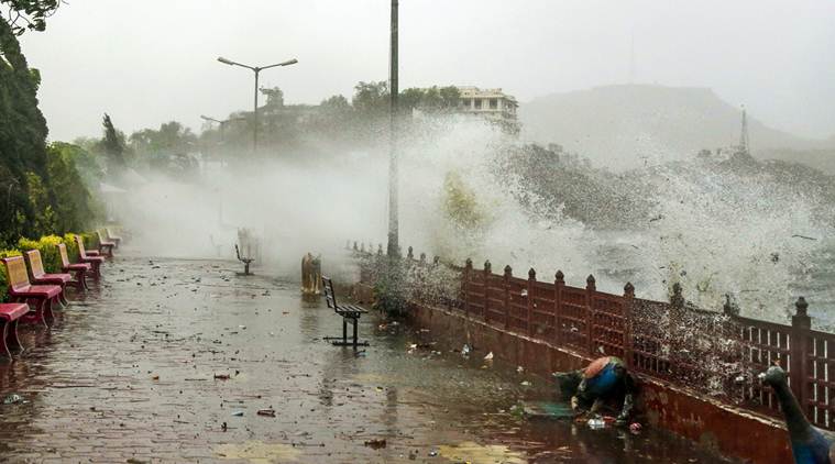
 Thunderstorm alert LIVE UPDATES: Water splashes out of Ana Sagar Lake during a thunderstorm in Ajmer on Tuesday. (PTI Photo)
Signalling that the freak weather phenomenon over northern India has moved eastward, the India Meteorological Department (IMD) warned that thunderstorm and squall with a wind speed of up to 70 kmph are “very likely” in Uttarakhand and parts of eastern India on Wednesday. The Met department released an advisory saying thunderstorm with gusty winds are “very likely” in parts of Himachal Pradesh, east Rajasthan, Uttar Pradesh, Bihar and Jharkhand. “A similar weather pattern is likely to be witnessed in West Bengal, and in six of the seven northeastern states except Mizoram,” it said. The National Disaster Management Authority also said that the thunderstorm and squall are likely to hit 12 states on Wednesday. Dust storm, rains and thunder left at least 100 animals dead in Jammu and Kashmir’s Rajouri district, uprooting trees and blowing the roofs off homes in Himachal Pradesh’s Shimla on Monday.
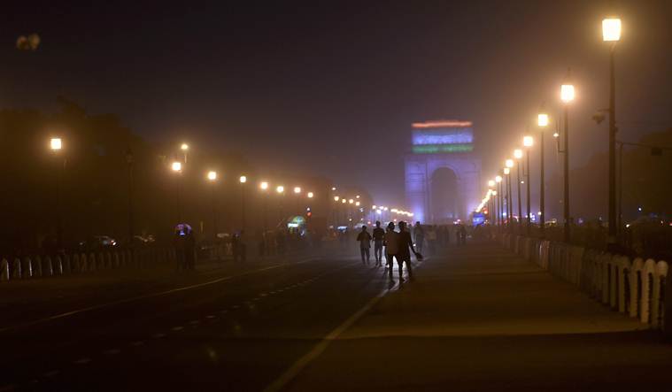 Thunderstorm alert LIVE UPDATES: A view of India Gate during a dust storm in New Delhi on late Tuesday. (PTI Photo)
Highlights
Dust storms, rain and thunder hit parts of northern India on Tuesday, leaving at least 100 animals dead in Jammu and Kashmir's Rajouri district, uprooting trees and blowing the roofs off homes in Himachal Pradesh's Shimla, but striking with less fury in other places.
The IMD had on Monday issued what is known as an amber-coloured alert, signifying the level of caution, that is needed to be followed. There are four types of colour codes signifying the level of caution: green (no action), yellow (situation to be watched), amber (government agencies to be prepared for severe weather) and red (action needed).
On Tuesday, the maximum temperature in Delhi was recorded at 34.7 degrees Celsius, while the minimum stood at 22 degrees Celsius.
According to the Safdarjung observatory, there were traces of rain in the last 24 hours.
In Delhi, the maximum temperature was recorded at 22.4 degrees Celsius, two notches below the season's average, it said. The humidity level recorded at 8.30 am in the city was 55 per cent.
Delhiites woke up to a cloudy morning today, after parts of the national capital witnessed dust storm coupled with light rains last night. The meteorological (MeT) department has predicted light rains in some areas of the city later in the day.
Skymet warned people to exercise caution and not expose themselves to inclement weather conditions. On May 2 night, over 100 people were killed during dust storm and lightning strikes that hit several parts of Uttar Pradesh and Rajasthan.
The NDMA had prepared videos on precautions to be taken during lightning. These videos were in English and Hindi and could be translated into local languages.
The parapet of a building collapsed in Badarpur area of south-east Delhi on Tuesday night, injuring three children and a woman. A Delhi Fire service official told PTI that the incident took place apparently due to high-speed winds.
The India Meteorological Department (IMD) stated on Tuesday: “Under the influence of the present Western Disturbance over J&K and neighbourhood; the cyclonic circulation over Haryana and neighbourhood and a north-south trough from East UP to Vidarbha in lower levels, thunderstorm accompanied with gusty winds and moderate squall (50-70 kmph speed) is very likely to continue at isolated places over J&K, Himachal Pradesh, Uttarakhand, Punjab, Haryana, Chandigarh and Delhi and West UP during next 24 hours…”
The PGCIL said: “On May 30, 2014, three lines of Power Grid had suffered damages due to excessively high wind speeds. Due to climate change, wind speed has increased in Northern India and wind zone has increased to level 5 against design value of Wind Zone-4 of these lines. Strengthening of towers has been taken up…to avoid such failures. The work of strengthening is being carried out progressively in phased manner.”
A similar incident happened on May 30, 2014, when a record 30 transmission towers either collapsed or were severely damaged across northern India after a dust storm, highlighting the fragility of the grid infrastructure.
A total of 22 power transmission lines went into “forced outage” in the northern grid on May 7, when a severe dust storm hit north India at various places. With officials working overtime, these lines were revived either on May 7 or May 8.
“Under the influence of the above two systems, widespread thunderstorm activity very likely simultaneously over northwest, central, east, northeast and peninsular India from May 13 onwards,” Sathi Devi said.
An easterly wave with an embedded lower level cyclonic circulation is very likely to affect states in the southern peninsula during the next week.
A fresh western disturbance is very likely to affect western Himalayan region from May 13.
Heat wave conditions are likely at one or two pockets over Vidarbha, interior Odisha and west parts of Jharkhand. The weather may be tumultuous next week.
“The western disturbance currently located over Jammu and Kashmir is very likely to move eastwards during next 24 hours and become unimportant. A cyclonic circulation in lower levels lies over Haryana and neighbourhood. It would move eastwards towards west Uttar Pradesh during next 24 hours and become less marked thereafter,” the IMD said.
The NDMA said that the National Capital Region, and Hisar, Kaithal, Jind, Kurukshetra, Karnal in Haryana is likely to be again hit by the unusual weather today.
The IMD said south-interior Karnataka, north-coastal Andhra Pradesh, Rayalaseema region of the state, Tamil Nadu and Kerala will also witness thunderstorm with gusty winds today.